
Rapid changes in GIS technology and software development environments have revolutionized the preparation and use of master plans for sewers. HDR Engineering, Inc. (HDR), working with the City of Stockton, dynamically linked GIS and engineering models and developed an interface that can update the model as the data sources in the GIS change. Model output can also be exported back to the GIS and the interface can be customized at minimal cost.
Using GIS data for master planning purposes and using an interface to transfer data from GIS to a hydraulic model are not new concepts. However, changes in the development environment for GIS applications has improved interface development. In the past, developing interfaces for GIS applications on the UNIX platform was expensive.
The advent of open development environments, which allow developers to use visual programming languages, and the development of ArcView GIS have meant that sophisticated, user-friendly interfaces can be developed within a typical master plan project budget.
Sewer master planning projects identify required system improvements and develop cost-effective solutions. Typically, a computer model simulates the hydraulic conditions in the sewer system. Previously, the cost to develop a data management system to support a database or a GIS interface for the hydraulic modeling of the system would have exceeded the cost of the engineering work. In most applications such a high development cost was unacceptable to clients. Costs to develop data management systems have come down, in part, because system inventory and land use data are now available in digital format.
Even with these improvements, effectively linking GIS data to the sewer master plan and developing an interface presented challenges.
The City of Stockton, with a population of 250,000, averages approximately 38 million gallons of waste water inflow per day. HDR was contracted to update the City's sewer master plan, find cost-effective ways to serve the rapidly growing northern and northeastern sectors of the City, and develop a GIS interface for the sewer model. Sewer block book information had been recently converted to GIS so it could be used in the sewer master plan model development.
General
Interface Requirements
 GIS
data structures, designed for general use within the organization, are
customer specific and were not designed for hydraulic modeling purposes.
In addition, the hydraulic model does not require all the data stored
in the coverages.
GIS
data structures, designed for general use within the organization, are
customer specific and were not designed for hydraulic modeling purposes.
In addition, the hydraulic model does not require all the data stored
in the coverages.
Models require data in specified formats. The GIS interface capabilities claimed by modeling software suppliers are limited to importing and exporting data in a predefined format and data structure. Consequently, data must be translated from a customer-specific format to the input format required by the model. To utilize modeling results in GIS, interface must also convert model output to a format that can be linked back to the GIS.
Interface
Design Objectives
> Maximize
the Use of Available Data
Interface design must
be tailored to the data available in the GIS to minimize the need to develop
and maintain new data sources.
> Work
with the Client's Existing Data Structures
The interface should
use the data in the format currently maintained in the GIS.
> Customize
the Interface to the Client's Needs
The sophistication
of the interface must match the user's needs and expertise.
> Interface
as Planning Tool
With a well-designed interface between GIS and the engineering model,
the master plan can become an interactive tool used to conduct development
impact assessments instead of a ponderous and seldom-used document.
> Maximize
the Flexibility of the Interface
The interface should allow the user to simulate different conditions in
the system, with minimal or no data input requirements and include handling
of multiple scenario model input and output files.
> Establish
a Data Management and Interface Maintenance Protocol
A GIS interface design should be documented with a protocol for maintaining
the data sources and the interface code.
> Minimize
the Cost of Interface Development
Although a well-designed interface might become the dynamic master plan
of the agency, the typical master plan project focuses on developing engineering
recommendations. The bulk of the budget should be spent on producing those
recommendations, not on the interface design and development.
HDR's approach provided an interface that adhered to the interface objectives while being cost-effective.
Data Sources
 HDR
reviewed the available GIS data and identified parcel, zoning, and traffic
coverages as the data sources to be used in the development of the land
use plan for sewer master plan development.
HDR
reviewed the available GIS data and identified parcel, zoning, and traffic
coverages as the data sources to be used in the development of the land
use plan for sewer master plan development.
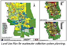
The parcel coverage, maintained by the City Planning Department, links each parcel to an activity table that defines the current type of development and the number of residential dwelling units.
The zoning coverage, also maintained by Stockton's Planning Department, identifies the zoning of existing parcels. A general plan coverage identifies the proposed zoning of undeveloped areas. These two coverages were not compatible because the land use categories were not consistent. Land use zones for the general plan were in gross areas that included street rights-of-way while the zoning coverage used net land use that zoned rights-of-way and other areas separately.
HDR developed a new land use zoning coverage that defines both the existing and proposed land uses as gross areas. The attributes for this coverage include general plan, zoning, and newly defined sewer plan land use categories.
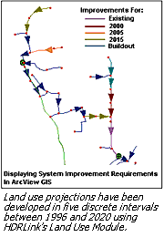
The City's Traffic Zone (TAZ) coverage was used to identify planning areas. In HDR's land use plan, planning areas are defined as areas with similar growth characteristics. A lookup table was developed to define the anticipated land use growth rate for each planning area and to define the expected year when development in currently undeveloped areas will commence.
Interface
Design
HDR's GIS interface
design used ArcInfo, ArcView GIS, HDRLink, and the hydraulic model. HDRLink
is a program developed in-house that includes several standard model configurations
and output functions. Raw data are stored and maintained in ArcInfo.
These data sources can be directly accessed through the network system
or data can be exported from ArcInfo to the desktop.
ArcView GIS provides the customized interface. Avenue scripts supply customized routines that convert GIS data to the model input format. These functions are accessed as Import, Export, and Setup menu items. Tools for editing the extracted model coverages are also included.
The Import function brings in sewer model and land use data from ArcInfo to ArcView GIS. The Export function transforms data from the sewer model format to the database format. The setup function customizes the interface to the client's specific requirements for such items as predefined legends or queries, symbol scaling, or assignment of model identification numbers.
Data Management
The interface is the
data flow path from GIS to the hydraulic model and back so the developer
must create a data management system that is practical, requires the minimum
user input, provides the flexibility to do "what if" scenarios, and is
easy to maintain. A thorough documentation of the data flow and data translation
processed is essential.
HDRLink provides standard data management, model setup, and output processing functions. HDRLink interface tool includes all noncustomer specific functions that can be grouped into five categories: project management, land use, model setup, flow assignment, and data output.
> Project management organizes all model input and output data as configuration and scenario data.
> Land use extracts data from GIS and exports them to HDRLink in a predefined format.
> Model setup uses "wizard-like" dialogs to assist the user in defining model parameters and for checking the completeness and integrity of the model input data.
> Flows assignment allows the user to assign flows from land use based flows, point source flows such as industrial flows, and wet weather infiltration or storm-related inflow and infiltration in addition to calibrating the unit flow generation factors and infiltration and inflow parameters.
> Data output functions let the user identify improvement requirements, estimate improvement costs, and develop output queries as well as accumulating output from several scenarios of the same configuration into a system status database table. This table can be linked to the model's input configuration in ArcView GIS for display, reporting, or querying of the model output.
The hydraulic model simulates the hydraulic conditions in the sewer system. In most applications, sewer and storm water modeling software has been used for this purpose. Because all standard data management and model configuration features are built into the HDRLink program, customization of the interface is limited to the ArcView GIS project, which minimizes cost.
HDRLink gives the modeler maximum flexibility with minimum data entry and file management requirements while preserving a user-friendly interface with a well-documented online help system.
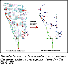
Extracting
the Model
 Hydraulic
models are constructed as links and nodes, with links connecting adjacent
nodes. Nodes are typically manholes, and links are lines such as gravity
pipes or force mains. Other model components, such as pumps, can be either
links or nodes depending on the modeling software. Conflicts between how
entities are shown in GIS and how they are modeled means GIS data must
be extracted prior to using these data in the model.
Hydraulic
models are constructed as links and nodes, with links connecting adjacent
nodes. Nodes are typically manholes, and links are lines such as gravity
pipes or force mains. Other model components, such as pumps, can be either
links or nodes depending on the modeling software. Conflicts between how
entities are shown in GIS and how they are modeled means GIS data must
be extracted prior to using these data in the model.
Other problems can arise because the hydraulic model usually does not include every entity stored in the sewer coverage and GIS sewer coverages may not be fully populated. The model extraction process must be able to filter out the data and construct a skeletonized model.
In addition to mismatches between model and GIS data, not all input required by models will have been stored in GIS. If the modeling software does not provide a user-friendly way for adding and editing these data, adding these features to the GIS interface should be considered. HDRLink provides editing capability and input assignment features.
Stockton's sewer coverage currently contains 19,630 line entities and 19,150 nodes. These entities represent sewer sizes ranging from 6 inches to 78 inches. The coverage's attribute table structure was designed to store the information that was extracted from the old sewer block book. The table includes information on (Page 29) pipe sizes and material, line slopes, and manhole ground and invert elevations.
However, the manhole elevations, pipe material, and slope records were only partially populated. In addition, the accuracy of the manhole elevations was suspect. Based on a thorough assessment of the available data and the modeling requirements, the model extraction interface was modified.
A Feature_id field was added to the coverage node attribute table giving a unique manhole number for each node in the system. A Sy_name field was added to the line attribute table_name that contained a unique link name constructed using the upstream and downstream manhole numbers.
Node and link lookup tables were added to store model specific data and the ground and invert elevations used in the model development. The model development was limited to lines 12 inches and larger. Smaller lines were only included if they were force mains or essential links in the model.
Key manholes essential to the development of a representative hydraulic model were identified. The ground and invert elevations for these nodes were determined using a combination of topographic surveying and various other reliable sources.
An Avenue script was developed to extract a skeleton model from the GIS coverage using the default attributes and the data from the lookup tables. The extracted model contains only the nodes with known elevations and reduced the number of links to 1,020 and the number of nodes to 975.
Transfer
Model Results to GIS
HDRLink creates an
output status database table. For the Stockton project, HDRLink was used
to summarize the output of several modeling scenarios of a specific model
configuration. This table was then linked to the model configuration file
in ArcView GIS to query and report the model output graphically.
The model extraction process includes a lookup table that links the entities in the skeletonized model with the original entities in the sewer coverage. A customized information tool button in ArcView GIS lets users extract model output information for entities in the sewer coverage. Clicking on the desired entity displays the original entity's attributes, the extracted model entity's attributes, and the model output data linked to the extracted model theme.
CONCLUSIONS
The development of
the GIS interface using ArcView GIS and HDRLink has provided the City
of Stockton with a practical, user-friendly planning tool to conduct "what
if" analyses and development impact assessments. Incorporating standard
data management and output processing features in HDRLink made it possible
to provide this sophisticated GIS interface at a minimum development cost.
References
Prins, J.G. and H.T.
Settle, Jr., Linking Comprehensive Land Use Plans with Water and Sewer
Master Plans Using GIS/Hydraulic Model Interfaces-A Case Study. Presented
at the North America Water and Environmental Congress '96, Anaheim, California.
About the
Primary Author
Dr. J.G. "Koos"
Prins, a
senior professional associate with HDR Engineering, has a master's degree
in Sanitary Engineering from the University of California, Berkeley and
a D.Eng. from the University of Pretoria, South Africa. A native of South
Africa, he moved with his family to the United States in 1991. He has
worked on hydraulic modeling of wastewater, stormwater collection systems,
and water distribution systems applications and has developed a cost-effective
integration of GIS with facility master planning.