

As deregulation takes effect, the business climate for utilities has a decidedly Darwinian atmosphere. Survival goes not just to the fittest but those companies who can do the best job of fitting information on facilities, customers, and competitors together to provide a competitive edge.
Utilities are no longer vertically integrated giants with rigidly defined service territories whose top priority is to satisfy a handful of government regulators. In response to market pressures, utilities are restructuring. Increasingly, today's utility is nimble, market-driven, and cost conscious.
Information
Is the Key
Utilities are transforming themselves intelligently by
salvaging useful parts of existing systems and incorporating new technologies
to extend their capabilities. The formula for a successful market strategy
is based on capturing and integrating information on company assets, processes,
customers, and market dynamics.
Information technology systems are key to utilities' success in this new environment. GIS has moved from an isolated, narrowly focused application to a critical component of new mainstream information technology. Automated mapping is an obsolete term. Companies are realizing that work is organized geographically. Enterprise GIS links GIS applications throughout an organization to realize benefits through maintaining data sets corporatewide. GIS provides much more than a map-it uses geography to provide the framework for all the major activities and components of a utility's business from customer locations to distribution pipelines.
The major benefits of implementing an GIS come from shared information. Several studies have shown that location-based data affect 80 to 85 percent of all information requests at a utility. Integrating geographic data with data from engineering and operations, corporate systems, accounting, and property records eliminates redundant data and the effort, expense, and currency problems associated with maintaining redundant records.
Though building GIS systems requires substantial investment, the value of true integration of corporate, engineering, and spatial data justifies the cost of implementation. Factors unique to each utility will affect the nature, extent, and difficulty of the integration problem. Legacy information systems often operate on different platforms with heterogeneous architectures. The requirements to manage system components may differ but no matter what specific strategies are involved in implementing GIS, the resulting system must do two things:- Drive down costs
- Improve customer service
Geodata
Availability: Driving Integration
 Not
only are the market forces of deregulation moving utilities toward the
use of GIS for enterprise solutions, but the use of GIS is spurred by
the much greater availability of spatial data. The ability to integrate
spatial data with nonspatial data in commercially available databases
such as Oracle and SQL-Server by using Esri's Spatial Database Engine
(SDE) has been a critical development in moving GIS into mainstream information
technology. Spatial data can now be used at all levels of a company.
Not
only are the market forces of deregulation moving utilities toward the
use of GIS for enterprise solutions, but the use of GIS is spurred by
the much greater availability of spatial data. The ability to integrate
spatial data with nonspatial data in commercially available databases
such as Oracle and SQL-Server by using Esri's Spatial Database Engine
(SDE) has been a critical development in moving GIS into mainstream information
technology. Spatial data can now be used at all levels of a company.
Though converting nondigital data remains an expensive and time-consuming process, much new data can be more easily captured in digital format using handheld computers in the field, GPS units, and other complementary technologies. The Internet has also been a big factor in disseminating spatial data.
Open
Development Environment and Information Technology Integration
Movement toward widespread use of GIS in the utility industry
motivated Esri to incorporate key technological improvements to a new
extension for ArcInfo. These improvements include the ability to manage
GIS data with commercial database management systems (DBMS), use of embeddable
objects for GIS, and the use of Windows-based, desktop systems that deliver
the same performance and functionality as earlier workstation products.
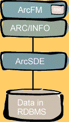
These trends have come together in ArcFM, a new ArcInfo-based application designed expressly for utilities. ArcFM, written in Visual Basic 5.0 for a Windows NT operating environment, adheres strongly to modern concepts of software engineering and user interface design. This completely open system allows all GIS data to be stored in industry-standard databases such as Oracle or SQL-Server via SDE.
ArcFM provides a complete, out-of-the-box solution for a single machine or across a two- or three-tiered system. Companies can jump-start new implementations or quickly modernize existing ones. With powerful data management and editing capabilities for facility and land base data, ArcFM software's capabilities include core editing, modeling, and data management of an enterprise system.
Use of open technology optimizes computing and infrastructure resources by allowing existing systems to be combined: SDE can be used as the data server, ArcInfo can be used for heavyweight GIS processes, and the Internet Map Server can support presentation of data supplied to desktop clients using Web browsers.
RuleBase
Engine: Key to An Evolutionary Migration Strategy
 ArcFM
software's architecture addresses a prime concern of utilities in today's
dynamic and fluid business environment: obsolescence. ArcFM uses the RuleBase
Engine (RBE) to encode the business rules of an organization such as avoidance
of device mismatches and topological and attribute validation into the
database design.
ArcFM
software's architecture addresses a prime concern of utilities in today's
dynamic and fluid business environment: obsolescence. ArcFM uses the RuleBase
Engine (RBE) to encode the business rules of an organization such as avoidance
of device mismatches and topological and attribute validation into the
database design.
Typically utility editors are very data dependent. ArcFM ships with four standard rule bases: electric, gas, water, and wastewater. Each rule base encapsulates all required domain-specific knowledge for each application area, which avoids lengthy and costly start-up customization. Long-term maintenance costs are also minimized.
Though customization is not required to receive great benefits from ArcFM, the application can be easily extended and customized to suit advanced user requirements. The database design is defined to the application through the rule base.
RBE simplifies and speeds application development. The underlying technology can change without impacting an existing application but the same rule base can support a new application. The database design supports all the applications and is nonproprietary. This means using RBE protects a utility's investment from obsolescence.
Access
and Maintain Data
ArcFM uses a work flow approach to data creation, management,
and use. Although many applications may use the data, maintenance of the
data is usually affected through four applications: map sheet editor,
desktop design editor, field design editor, or a tabular data entry system
that is associated with legacy systems. ArcFM provides all the editing
functions that are associated with creating and maintaining a utility
distribution system.
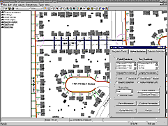
Feature editing functions include handling symbology, facilitating feature placement, enforcing topological connectivity, and referential integrity. The symbology shows the presence of fittings or devices and provides information as to their size, type, and other attributes.
There are many state-of-the-art tools for managing facilities in a multiuser environment including coordinate geometry construction, long transaction/version management support, and network tracing. Used with SDE, ArcFM provides true version management. ArcFM includes a tool set to build and maintain a utility's database, and define both the cartographic representation of facilities and the underlying model structure. The user interface has a modern Windows look and feel with dockable tool bars, drag and drop functionality, and a tree view of data.
ArcFM tools enforce topological connectivity that verifies that features linked in the GIS are actually connected, not just graphically represented as connected. Referential integrity is also maintained both between the GIS and related database tables and between database tables. For example, if a transformer bank is deleted, all transformer units associated with the bank are also deleted.
Find
Answers Now
To remain competitive, utilities need answers quickly-whether
it is locating an outage or managing distribution most effectively. The
ArcFM family of products includes ArcFM Viewer, a lightweight desktop
application that distributes the query and view functionality throughout
the enterprise. ArcFM Viewer can be used by personnel throughout the organization
from executives to customer service representatives. The combination of
spatial and logical queries quickly yields answers (page 17) to questions
that require much time and labor to answer using manual methods. Query
results can be formatted into reports and displayed as business graphics.
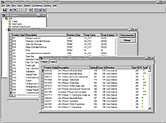
ArcFM Viewer gives fast, easy access to spatial data and provides viewing, querying, reporting, charting, mapping, and output functions. Developed using Esri's MapObjects technology for graphics display, ArcFM Viewer makes direct use of the Microsoft Foundation Class library which results in the fastest display available for data. By using true client/server database components written for direct interaction with SQL database tables, ArcFM Viewer can query DBMS tables in place. ArcFM Viewer uses the same rule base tables as the ArcFM application to determine which tables are associated with specific GIS features which minimizes customization requirements.
Utilities rely on maps for operational purposes. From the quick checkplots and single-sheet maps to detailed distribution and transmission facilities maps, savings can be realized by deriving these different view maps from a single integrated data source.
The usability of maps can also be improved through simplification of features and user control over annotation display, making data easy to read. Raster images, sketches, and scanned maps can be imported. Map documents can be cut and pasted into other documents and saved to various formats, making sharing data much easier.
Embracing
Integrated Solutions
With the convergence of technologies and utilization of
increasingly powerful desktop applications, utilities with extensive as
well as minimal GIS implementations can benefit from moving from a proprietary
to an open development environment.
In 1992, the state government in Western Australia commissioned the Energy Board of Review to investigate ways to improve the efficiency of the energy business in the State. The Board came back with a recommendation the State Energy Commission of Western Australia, which supplied gas to the area, be split into a number of competing businesses.
Alinta Gas of Perth, Australia, was created as a result of state government moves to deregulate the market. Alinta, which manages one of the world's longest natural gas distribution pipelines, is using ArcFM to develop an integrated GIS solution to remain competitive while effectively serving its 350,000 residential, business, and industrial customers.