by Steve Kopp, Esri
|
|
Developing
a Hydrology Extension for ArcView Spatial Analyst
by Steve Kopp, Esri |
|
Extensive flooding from the El Niño weather phenomenon has renewed interest in using GIS software to understand and predict flood problems. Over the past five years, many interfaces have been developed between GIS and hydrologic models. Most have linked rainfall-runoff and hydraulic models, particularly HEC-1 and HEC-2, to ArcInfo. These home-grown converters or data bridges are useful only to their developers or a few people in their office and work with only one GIS package and one hydraulic model. Most of these converters are built for lumped parameter models that use single values of attributes stored for each watershed or stream reach. Flood
Mapping Scenario The runoff information from the hydrologic model can then be combined with stream cross-section information in a hydraulic model such as HEC-2 to determine how deep the water would be at given locations. These water surface elevations can then be passed back to ArcView Spatial Analyst and overlaid upon the terrain surface to determine which areas will flood. Several recent developments have made the process of interfacing GIS and hydrologic models easier. First, the development of ArcView Spatial Analyst provided raster modeling capabilities on the desktop, where most hydrology work is done. ArcView Spatial Analyst also led to the adoption of a simple, open standard vector format -- the Esri shapefile, which facilitates data exchange and conversion. Finally, new object-oriented models from the Corps of Engineers Hydrologic Engineering Center (COE-HEC) were developed. These models, the Hydrologic Modeling System (HMS) and the River Analysis System (RAS), are HEC's replacements for HEC-1 and HEC-2. However, the information required for all such models is similar. Project
Goals
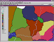
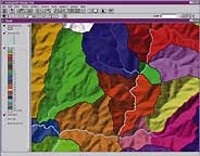
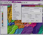
With these goals in mind, developers from Esri, Brigham Young University's Engineering Computer Graphics Lab, and University of Texas at Austin's Center for Research in Water Resources designed a software framework, an attribute encoding scheme, and an ArcView GIS extension to work with rainfall-runoff models. By using an open data format, both the GIS and the model can directly read and write in the file without conversion. The result was the new hydrology extension for ArcView Spatial Analyst Version 1.1. This new tool extends the ArcView Spatial Analyst user interface for creating input data for hydrologic models. With this extension, users can create watersheds and stream networks from a digital elevation model (DEM), a grid data source representing elevation. Users can calculate physical and geometric properties of watersheds, and aggregate these properties into a single attribute table that can be attached to a grid or shapefile. Depending on your needs there are two ways of approaching this functionality. If you simply want to create watersheds or stream networks, or a particular property of them, work directly with each of the functional choices under the Hydrology pulldown menu. If you want to create watersheds and calculate attributes for them, use the Hydrologic Modeling choice under the Hydrologic pulldown menu. This chart shows the menu choices and functions available with the hydrology extension. Working
with Models Surface water profiles created using HEC-2, RAS, or other modeling software, can be read back into ArcView Spatial Analyst to create flood maps for further map overlay analysis. Though this project was developed to share information between ArcView Spatial Analyst and WMS, the file format and description for this extension are easy to understand and can be used as a starting point for development of similar GIS-model interfaces. Work is also under way to combine this extension with the University of Texas PREPRO program which would allow an ArcView GIS user to directly create input files for HEC HMS, Danish Hydraulic Institute's MIKE Basin, and perhaps the SWAT models. Additional work is being done to further connect HMS and RAS in a single ArcView GIS environment that would allow you to move easily from a DEM to a floodplain map within a single application.
How
To Get the Hydrology Extension |
|
|
||||||||||||||||||||||||||||||||||||||||||