
The City of Ontario
Collects Revenue More Efficiently
Faced with the uncertain economic climate in Southern California in 1993, many cities realized they needed to collect existing revenues more vigorously. Noncompliance with local business licensing laws was costing them thousands of dollars in lost license fees and sales tax, and uncollected penalties.Instead of simply spending more staff time using the same old collection methods, the City of Ontario "built a better mousetrap" using the City's GIS. The resulting application was less labor intensive and produced far more revenue than more traditional methods.
 Ontario, located in Southern California, has 6,000 businesses in its 36.8-square-mile jurisdiction. The potential revenues to be gained were enticing but the task of physically inspecting all businesses in the City was formidable. The traditional method of finding illegally-operating businesses required employees of the Revenue Division to canvass each neighborhood block by block on foot and then manually cross-reference licenses and inspections.
The revenue application began as a request from the Revenue Division for a map showing the commercial and industrial locations in the City. Revenue Division staff would be sent out to do a physical inventory based on this map that would focus their efforts and eliminate areas where businesses were very unlikely to be found. This original plan would have increased the efficiency of the physical inventory, but GIS staff realized that this audit could be more effectively done without ever leaving City Hall.
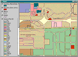
 A pilot program was devised to test the GIS audit concept. Using ArcView GIS, staff searched the land use database for all parcels containing two or more commercial or industrial uses such as high rises, shopping centers, or industrial parks. The data associated with the assessor's parcel number (APN) were extracted and cross-referenced to the business license data file.
All parcels lacking a sufficient number of licenses for the reported uses were matched to the property owners and property management firms. Five hundred and seventy parcels were found that fit this profile. Mailing labels were generated from the business license database and generic letters sent to all property owners or management firms requesting a list of tenants.
The tenant list created from the responses obtained was run against the business license file. Tenants without business licenses were identified and notified by mail. Funds, not only for delinquent licenses but also for sales tax, were collected without staff having to walk a single City block.
 The $114,972 collected by the pilot program was just the beginning. Business license recovery is the gift that keeps on giving. Once businesses have been identified and entered into the city database, they become an ongoing source of revenue. This revenue was realized using just two hours of staff time from the GIS department to perform the property searches and analysis, generate files, and create labels, all at a cost of just $30. This contrasts sharply with the 117 hours and $13,062 that would have been needed to perform a traditional field inventory.
GIS is effective because it taps into the geographic component--whether it is an address or a parcel number--that ties city database files to locations in the real world. This makes "invisible" businesses magically appear. Businesses present in the parcel layer are conspicuous by their absence from the business license database.
Not only does GIS allow efficient analysis of city databases for revenue auditing, but it is a project management tool for conducting and monitoring audits. The area to be audited can be divided into manageable chunks so that staff are not overburdened. Map-driven audits allow for a systematic inventory of the entire city in a timely fashion. Areas of noncompliance can be targeted. These project management benefits of GIS audits are intrinsic. No extra project management program requiring staff training time and maintenance is required.
The ease of use of ArcView GIS coupled with the ability to customize the interface and functionality for users meant the system could move into the department with a minimum of training and resistance. The application has been popular with Revenue Division staff who appreciate that it makes them much more effective. "By using the GIS technology, it has certainly made my job easier, faster, more accurate, and efficient. I am able to audit for unlicensed businesses by computer and maps rather than complete field work. GIS is great!" says Pansy Welton, auditor/collector for the City of Ontario.
Because ArcView GIS is able to easily integrate data from many sources, city license files can be run against commercially available data sets such as MetroScan and TRW. These data sets are a cost-effective way to get data that are updated much more frequently than assessor's data. Geocoding verifies data from city files by forcing data back into the database that would otherwise drop out if selections were made by areas such as ZIP Codes or census blocks.
A natural progression from the Business License Audit was the Commercial Property Audit, which identifies owners of commercial land who lease out their properties but do not pay business license or sales taxes to the City as required. While the traditional Commercial Property Audit found $27,000 worth of license income, the GIS implementation of the same audit generated $200,000.
The success of the business license and commercial property audits quickly led to revenue audits for other fees and licenses. The City of Ontario currently performs GIS audits on industrial parks, commercial properties, warehouse properties, and on the downtown assessment area, as well as creating maps for outside consultants to use in field audits.
The newest auditing application is the Fictitious Business Name Audit. It is not uncommon for businesses to file a "Doing Business As" statement with county, state, and federal agencies, but to then fail to obtain a current local business license. Ontario purchased the "Doing Business As" county database file for a mere $5, ran the file against City records, and uncovered illegally operating businesses that were not previously found.
Chris Thomas, former GIS coordinator for the City of Ontario and now local government industry manager at Esri, originated and refined revenue auditing for Ontario. He strongly believes starting a GIS program with revenue auditing may be the best route for many cities currently without GIS capabilities. "Revenue auditing with GIS allows a city to grow their GIS by quickly producing revenue and enlisting the support of city officials," says Thomas.
To learn more about how the City of Ontario is using GIS, visit the City Web site at www.ci.ontario.ca.us/index.cfm/3293.