|
How GIS Is Changing Loma Linda University Medical Center's View of the World
By Ruthita Fike, MA
Chief Executive Officer, Loma Linda University Medical Center
Geography is more than just a place on a map with distinctive topographic features. It fundamentally influences and connects our many cultures, societies, and ways of life.
Geography also plays a critical role in improving health care. At Southern California's Loma Linda University Medical Center (LLUMC), we're embracing the emerging discipline of health geoinformatics, which uses innovative scientific and geospatial technology to investigate health issues.
A multifaceted collaboration involving the use of GIS technology is changing how LLUMC and the associated health sciences university, Loma Linda University (LLU), relate to the world. And because of the almost limitless possibilities of GIS, we have been able to create a better future for those whose lives we touch. .
|

|
ArcGIS 9.2 Service Pack 3 Available for Download
Install ArcGIS 9.2 Service Pack 3 to ensure the highest-quality experience when working with ArcGIS 9.2. . |
|
ArcGIS Survey Analyst 9.2 with Cadastral Editor Now Available
Improve the accuracy of your parcel data with ArcGIS Survey Analyst 9.2. This extension is available as part of ArcGIS 9.2 Service Pack 3. . |
|
Esri Developer Network Expands Options
 The Esri Developer Network (EDN) recently added two more ArcGIS Desktop choices to help developers who want to incorporate geography and mapping capabilities into their applications. In addition to the previously released ArcView Single Use option, you can now add ArcInfo or ArcEditor for an additional cost. . The Esri Developer Network (EDN) recently added two more ArcGIS Desktop choices to help developers who want to incorporate geography and mapping capabilities into their applications. In addition to the previously released ArcView Single Use option, you can now add ArcInfo or ArcEditor for an additional cost. . |
|
Learn How GIS Benefits Public Works Departments
Esri will host a series of free seminars across the country in September and October that focus on explaining how GIS can help public works departments optimize routing, improve customer service, and reduce costs such as money spent on fuel. The seminars will be held in 19 U.S. cities including Anaheim, California; Columbus, Ohio; Dallas, Texas; Portland, Oregon; and Raleigh, North Carolina. Learn about the locations and dates of all the seminars and . |
|
Read a Q&A with Jack Dangermond
 Esri president Jack Dangermond provided in-depth answers to 142 questions posed by Esri software users prior to the 2007 Esri International User Conference (Esri UC). These included What are Esri's plans for ArcGIS 9.3? and Is ArcIMS going away? (Short answer: "Absolutely not.") . Esri president Jack Dangermond provided in-depth answers to 142 questions posed by Esri software users prior to the 2007 Esri International User Conference (Esri UC). These included What are Esri's plans for ArcGIS 9.3? and Is ArcIMS going away? (Short answer: "Absolutely not.") . |
|
Evaluate ArcLogistics Route Software for Free
Receive a 60-day trial of ArcLogistics Route 3 software on a CD, which includes data for a tutorial. ArcLogistics Route 3 helps companies save time and money when dispatching drivers to deliver goods or services. Learn more and . |
|
Download Best Practices Booklet
In , you will learn how organizations such as the U.S. Geological Survey are using GIS to upgrade their databases and mapping operations. GIS Best Practices booklets are available on a variety of topics such as public works, law enforcement, and customer and market analytics. For a complete list of booklets currently available, visit the showcase. |
|
Get Started Accessing ArcMap
The ArcMap table of contents (TOC) does more than help locate information in a map document. The TOC also serves as a "control center." There, people can access controls for changing how data is displayed and symbolized as well as tools that will let them select, label, and manipulate data layers and the map in data and layout views. about how to save time using the TOC in ArcMap. [PDF - 548KB] |
|
NASA Launches GIS at Wallops Flight Facility
 Goddard Space Flight Center's Wallops Flight Facility in Virginia recently switched from a legacy computer-aided design (CAD) system to GIS for mapping its facility, environmental, range safety, and mission management data. Using Wallops' new Geographic Information System Managing Operations (GISMO), employees create maps for distribution over the organization's intranet. Wallops uses ArcGIS Server 9.2 Standard Workgroup to manage the storage and distribution of its GIS database and application. . Goddard Space Flight Center's Wallops Flight Facility in Virginia recently switched from a legacy computer-aided design (CAD) system to GIS for mapping its facility, environmental, range safety, and mission management data. Using Wallops' new Geographic Information System Managing Operations (GISMO), employees create maps for distribution over the organization's intranet. Wallops uses ArcGIS Server 9.2 Standard Workgroup to manage the storage and distribution of its GIS database and application. .
|
|
Teach Students about Africa Using GIS
 National Geographic's MapMachine and Esri's Geography Network will help hone students' skills in geography and geospatial analysis. The , powered by Esri technology, allows anyone to explore the earth through the creation of customizable maps at any scale. One lesson involves using MapMachine to study where snow falls in Africa. . National Geographic's MapMachine and Esri's Geography Network will help hone students' skills in geography and geospatial analysis. The , powered by Esri technology, allows anyone to explore the earth through the creation of customizable maps at any scale. One lesson involves using MapMachine to study where snow falls in Africa. .
|
|
Get Started Using ArcGIS Server Out of the Box
Learn the workflow for using ArcGIS Server including authoring a GIS resource, publishing the GIS resource to ArcGIS Server as a service, and using the service from a client application. . [MP3 - 8:45]
|
|
GIS Quickly Expanding to the Enterprise
Rather than limiting the use of GIS to one or two departments, more companies, agencies, and other organizations recognize golden opportunities to provide geospatial data to their employees and clients across the enterprise. In this podcast, Dave Busser, Esri's director of corporate and business development, talks about why using enterprise GIS is a smart business move and how to start planning to launch one. . [MP3 - 15:22]
|
|
Heading EAST: Spatial Technology Program Teaches Students GIS
The Environmental and Spatial Technology (EAST) initiative, now in more than 200 schools nationwide, teaches students to use technologies such as GIS for a variety of worthwhile projects. For example, one student in Maui, Hawaii, used GIS to study the spread of the banana bunchy top virus (BBTV), which is carried by the banana aphid. . [MP3 - 18:00]
|
|
New Edition of Cartographic Relief Presentation Published
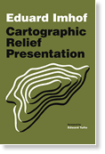 Esri Press recently released a new edition of Eduard Imhof's classic Cartographic Relief Presentation. Last published 25 years ago and difficult to find, the volume showcases the skillful draftsmanship, artistry, and science that went into the renowned Swiss cartographer's relief maps.
. Esri Press recently released a new edition of Eduard Imhof's classic Cartographic Relief Presentation. Last published 25 years ago and difficult to find, the volume showcases the skillful draftsmanship, artistry, and science that went into the renowned Swiss cartographer's relief maps.
.
|
|
Free Seminar Will Help in Managing Cadastral Land Records
Tune in to a complimentary online live training seminar on September 13, 2007, for a demonstration of the new Cadastral Editor in ArcGIS Survey Analyst. During , you will learn how you can use this technology to add new parcels and control points as well as split parcels. .
|
|
Get Comprehensive Training Suggestions with New Web Tool
Do you need Esri software training to succeed in your job but don't know which course is right for you? The Recommended Courses Web tool will help you find training that's focused on your needs. This interactive resource will assist you in choosing appropriate courses in your area of interest based on your previous training, skills, or job responsibilities. .
|
|
Download the Colorful Esri Screen Saver
 An eye-catching screen saver from Esri communicates the power of GIS. It's Windows compatible and easy to .[ZIP - 3.08 MB] An eye-catching screen saver from Esri communicates the power of GIS. It's Windows compatible and easy to .[ZIP - 3.08 MB] |
|
Join in Celebrating GIS Day
Do you have plans for Wednesday, November 14, 2007? Join the community of GIS professionals, students, and educators from more than 80 countries who have marked their calendars to celebrate the ninth annual GIS Day. Hosting a GIS Day event is fun, easy, and rewarding. You can help spread geographic awareness, promote GIS, recognize the impact the GIS community makes on vital everyday tasks, and help people understand real-world problems. Simply will get you one step closer to becoming involved in the global celebration.
|
|
Buy Online
Esri offers U.S. customers the new Z series photo printers and the large-format color copier, scanner, and printers. In addition, we now have some new small-format printers available.
Visit the to find more software and extensions, upgrades, data, books, and hardware bundles.
|
|
|
|
| Events
Calendar |
 |
-
-
-
-
-
-
-
-
-
-
-
-
|
|
|
|
|
|
| Career Connections |
|
Esri Job Opportunities
Account Managers
Selling Solutions That Make a Difference
Join Esri's Sales Division and you can help customers solve business problems with our cutting-edge technology. We are looking for people with a wide variety of backgrounds, interests, and skills who share our commitment to delivering the highest level of service and solutions to our growing user base.
Utilize your sales and industry expertise in these areas:
- Commercial
- Petroleum
- Utilities
- State and Local Government
- Federal and Defense
Learn more about our professional opportunities in .
Visit our Web site to search all career opportunities.
|
|
|
|
|
|
|
|
|
|

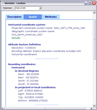 In ArcGIS Desktop 9.2, metadata for one or more layers can be accessed directly from ArcMap, ArcGlobe, and ArcScene without opening ArcCatalog. .
