January 19, 2010
Omega Group Deploys Esri Technology for Its Crime Mapping Site
GIS Makes It Easier to Provide Valuable Incident Data to the Public
|
Images for Publication
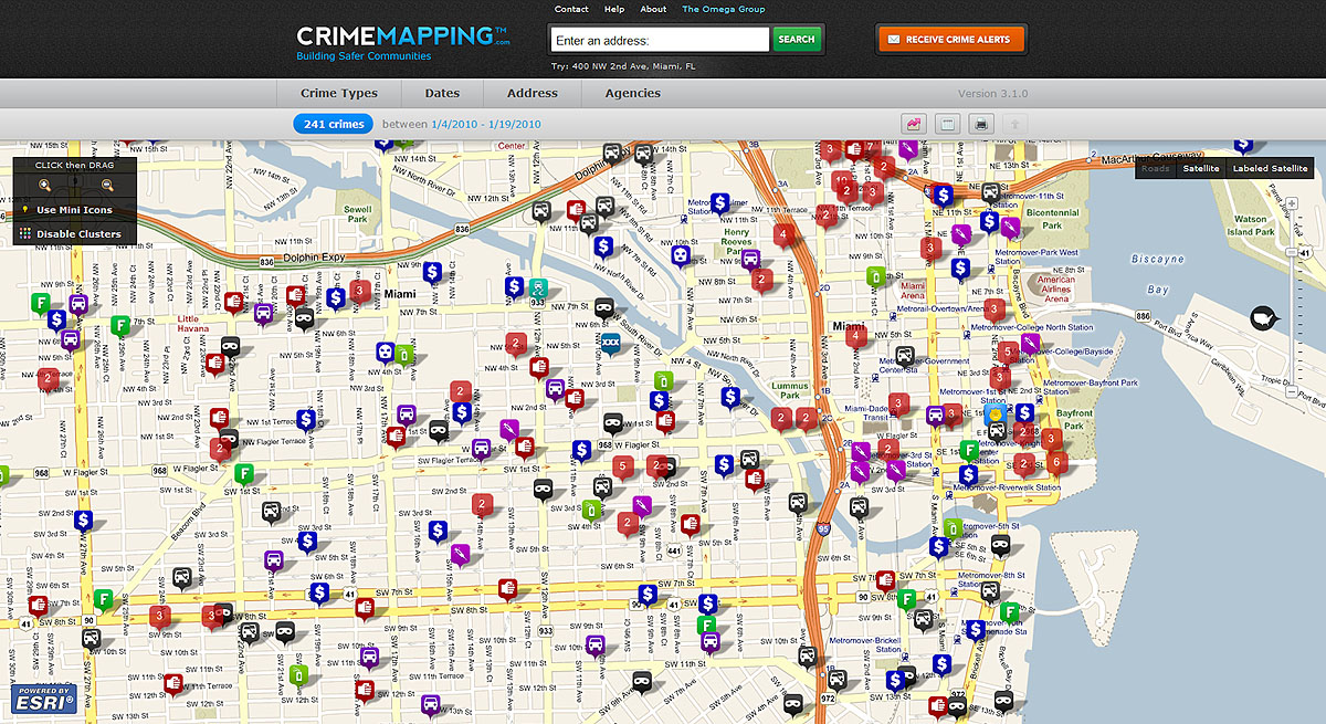
The Web site displays where multiple incidents occurred at the same location. Miami, Florida |
Redlands, California—The Omega Group has recently upgraded its Crimemapping.com Web site using Esri geographic information system (GIS) technology. The newly improved site allows law enforcement agencies to automatically upload crime data for public consumption via the Web. Site visitors view digital maps of their area of interest and have a fast and efficient method to point and click their way to information. In addition, people can learn about crime activity near their home or business by subscribing to Crime Alerts, automated e-mail notifications that are sent out whenever new activity occurs in their area. The service is free to the general public.
"Keeping the public well informed has been effective in reducing crime," says Milan Mueller, president of the Omega Group. "Putting crime data out there helps promote transparency and trust. We developed the site in response to the needs of our law enforcement community, which we've been serving since 1992."
"The Omega Group is a pioneer in crime mapping throughout North America," says Lew Nelson, retired police chief and law enforcement solutions manager for Esri. "Crimemapping.com allows police agencies to use their own data combined with advanced geocoding capabilities. It supplies accurate, up-to-date crime information to the public using an intuitive Web site."
More than 75 agencies from all over the United States take advantage of Crimemapping.com, including San Francisco, California; Anchorage, Alaska; Ft. Worth, Texas; Bethlehem, Pennsylvania; Duluth, Minnesota; and Miami, Florida. More than 80 other agencies are scheduled to go live in a few weeks.
Citizens take advantage of a digital map interface to learn more about crime in their neighborhood. They can scroll over an incident icon—such as a DUI or burglary—to view more information on the specific incident, such as time, description, and date.
The Omega Group works with each agency to upload incident data directly into the Web site database. Participating agencies agree to have their crime data extracted on a regular basis from each department's records system. This ensures that the information being viewed through a Web browser is always the most current available. The site maintains a high level of location accuracy by geocoding against local Esri street maps.
Omega selected Esri's ArcGIS API for JavaScript to develop its rich, interactive application. The API allows Omega developers to add content to the map via online services, develop custom tools and widgets, and add GeoRSS feeds and other Web content. The API connects to ArcGIS Server, which operates as the mapping and spatial analysis platform for publishing GIS functionality as Web services. Using the ArcGIS Server environment to spatially enable crime data significantly reduces storage costs and data processing overhead.
# # #
Press Information:
Jesse Theodore, Esri
Tel.: 909-793-2853, extension 1-1419
E-mail (press only): press@esri.com
General Information: info@esri.com