April 22, 2010
Renewable Energy Atlas Shows Vermont's Energy Options
Green Map Powered by Esri Is Launched on Earth Day
|
Images for Publication
|
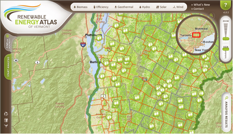
Redlands, California—The Renewable Energy Atlas of Vermont, built on Esri's ArcGIS technology, was launched on Earth Day, April 22, 2010. Web site visitors can identify, visualize, and analyze data about existing and promising renewable energy projects for Vermont's towns and counties.
Visitors to the Renewable Energy Atlas of Vermont Web site can select from biomass, efficiency, geothermal, hydroelectric, solar, and wind renewable energy data layers and use geographic information system (GIS) tools to view existing and proposed projects by area. All renewable energy data layers were created and analyzed using Esri's ArcGIS Desktop software and published with ArcGIS Server.
The Renewable Energy Atlas of Vermont will assist town energy committees, funders, educators, planners, policy makers, and businesses in making informed decisions about renewable energies in their communities, decisions that ultimately lead to successful projects, greater energy security, a cleaner and healthier environment, and better quality of life across the state.
The Vermont Sustainable Jobs Fund, Vermont Center for Geographic Information, Fountains Spatial, and Overit Media collaborated to develop the atlas in hopes of moving the state's renewable energy projects from concept to reality. Esri provided professional service support.
"We were looking for a way to show people how renewable energy flows through their communities so they can see the options for harnessing it," said Scott Sawyer, research, evaluation, and communications coordinator at Vermont Sustainable Jobs Fund. "The Web site lets them zoom in to a town level or subtown level and look at the renewable energy and efficiency possibility. Our goal was to make the Web site easy and fun. GIS technology, good data, Web design, and easy-to-use applications made this possible."
The suite of renewable energy options is further broken down into 20 categories of data for specific renewable energy analysis. For example, users can select options for a town, biodiesel, and vegetable oil and see all the restaurants where they can potentially find vegetable oil waste that could be useful for making biodiesel fuel. The site also provides tools for calculating energy potential. A solar model, for instance, allows users to enter a roof's facing direction, tilt, and percentage of tree shade and produce a calculation of solar energy potential.
The basemaps for the Web site have a beautiful cartographic look. These were acquired from Esri's ArcGIS Online basemap services (World Street Map and World Imagery).
"We are excited to work on the project that supports Vermont's green economy," noted Mark Haberle, senior project manager at Fountains Spatial. "Esri's GIS technology enables the development of tools for robust information discovery and dissemination that makes it easy for people to understand the possibilities of renewable energy. It is our hope that the Renewable Energy Atlas of Vermont will support sustainable job development for Vermont and help the state meet its vision for a carbon-constrained future."
"GIS technology provides a means for citizens to become informed about their communities and actively participate in making them environmentally sustainable," said Robin Smith, Esri's environmental solutions manager. "Esri is encouraged by Vermont's use of geospatial technology to help its citizens participate in the state's renewable energy efforts."
Learn about developing a renewable energy Web site for your community by contacting Haberle at Mark.Haberle@fountainsamerica.com. Learn more about Esri's GIS solutions for the environment at www.esri.com/environment.
# # #
Press Information:
Barbara Shields, Esri
Tel.: 909-793-2853, extension 1-2641
E-mail (press only): press@esri.com
General Information: info@esri.com