National Geographic Society and Esri Agreement Helps Broaden the Geographic Story
Registration Open for the 2010 EGUG Conference
July 13, 2010
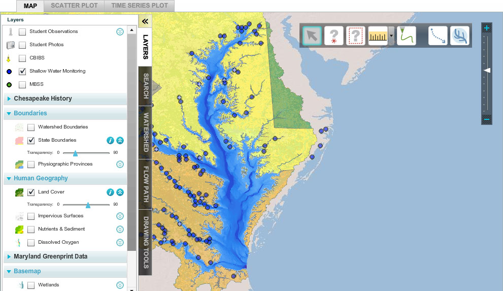
FieldScope project provides Web-based mapping tools for analyzing water quality and land cover.
Redlands, California—The National Geographic Society has signed a nonprofit site license (NSL) agreement with Esri that allows expansion of the geographic information system (GIS) user base within the society and improves public access to geographic data. The NSL gives the National Geographic Society unlimited deployments of ArcGIS software, thereby providing greater support of the society’s goal of increasing and diffusing geographic knowledge.
“Our relationship with Esri and use of its products over the years has helped us more effectively utilize GIS technology in our cartographic workflow and analysis,” says Charles Regan, vice president and general manager, National Geographic Maps. “This new agreement will provide our staff with even greater access to GIS applications and data, allowing us to better incorporate geographic information into our storytelling.”
Esri has worked with the National Geographic Society for more than 25 years and has provided solutions for robust analysis of geographic data.
National Geographic Society will use the NSL to
- Improve efficiency in data sharing.
- Reduce GIS maintenance and support costs.
- Deploy ArcGIS on more desktops and give employees greater access to GIS applications and data.
- Enable more people to use spatial data and analysis to effectively tell stories.
The National Geographic Society will deploy Esri’s ArcGIS Server technology both on the premises and in the cloud. These Web-enabled applications are being designed to help the public have a more in-depth and interactive experience with geographic information.
“Historically, the National Geographic Society has been preeminent in using geography to tell compelling, dramatic, and engaging stories,” notes Jack Dangermond, president of Esri. “The society has gone far beyond the service of delivering maps and data. It uses GIS as an education tool to describe the cultures, landscapes, and environments of our world. This NSL affirms Esri’s support of the National Geographic Society’s work and continues our longstanding relationship, respect, and appreciation of the many education projects it provides the world.”
National Geographic uses ArcGIS for a wide range of data production, cartography, publishing, and analysis tasks. Staff often queries and combines datasets to create statistics and graphs for National Geographic maps, Web sites, and magazine articles. For example, National Geographic’s FieldScope application uses ArcGIS to enable students and citizen scientists to compute watersheds and flow paths on the fly. This helps them understand how water flows to and from their locations. In addition, ArcGIS Server enables LandScope America, an online resource for land protection that is a collaborative project of NatureServe and National Geographic Society, to publish hundreds of conservation map layers at multiple scales and extents. LandScope America also uses ArcGIS Server to make available thousands of geotagged articles, photos, and videos.
# # #
Press Information:
Barbara Shields, Esri
Tel.: 909-793-2853, extension 1-2641
E-mail (press only): press@esri.com
General Information: info@esri.com