概述
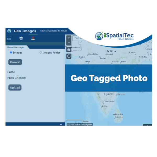
This widget enables user to retrieve the latitude and longitude information stored in the image files Exchangeable Image Format (EXIF) data. Geotagged photos can be added to a map by publishing them as a point feature layer. A point feature layer is created based on the location stored in each photo, with the photos themselves being stored as an attachment to the point. The points are not created for non-geotagged photos. The resultant feature layer can be added to any web map, and photo attachments can be viewed from the pop-up. The widget supports all standard photo formats such as JPEG, PNG. User can upload single image or multiple images which can be added from local system path.
https://widgets.smartgeoapps.com/uploadgeoimage/index.html#
Benefits of the iSpatialTec GeoTagged Photo widget:
This widget automatically extracts coordinate information from the images that are geo tagged during field collection including image metadata fields and add them to the feature’s attributes. This widget creates point feature in the specified service with the attributes as Lat/Long values which are generated from this widget. By using this widget, we can directly extract point features in ArcGIS Online so that the field team can cross verify the quality of geotagged images collected during field survey.
Geotagged Photos Widget User Manual
For any assistance Contact Us
Connect to www.ispatialtec.com | connectus@isaptialtec.com for more information.

業務需求
- 資產追蹤和分析
- 設施管理
- 現場服務管理
- 即時位置追踪
- 市場與客戶分析
產業
- 架構、工程與建築
- 電力和瓦斯公用事業
- 國家政府
- 州政府和地方政府
- 水
所用平台
- 桌上電腦
- 內部部署
- Mobile
- Web
系統要求
Web AppBuilder 2.10 or above
Supported Browsers & Devices: IE 7 & Above, Chrome | Desktop, Mobile & Tablet
版本
2.13
列出日期
Jan 8, 2021
聯絡資訊
iSpatial Techno Solutions Inchttp://www.ispatialtec.com/電子郵件+1 (858) 5229799