The Wyoming Department of Transportation’s Interactive, Mobile-Friendly Map Helps Truckers, Tourists, and Locals Plan Safe Trips

Known for its rugged beauty, Wyoming is a place where cowboys and wildlife still roam the plains. While the state’s population numbers just over a half a million people, millions visit each year to see Yellowstone National Park, Grand Teton National Park, and Devils Tower National Monument; go skiing, hiking, and fishing; and experience vast wilderness.
With 6,800 miles of highway, Wyoming also serves as a major corridor for commercial truck traffic—particularly on Interstate 80, which runs through the southern part of the state. It is one of the busiest routes in the United States for moving freight from coast to coast.
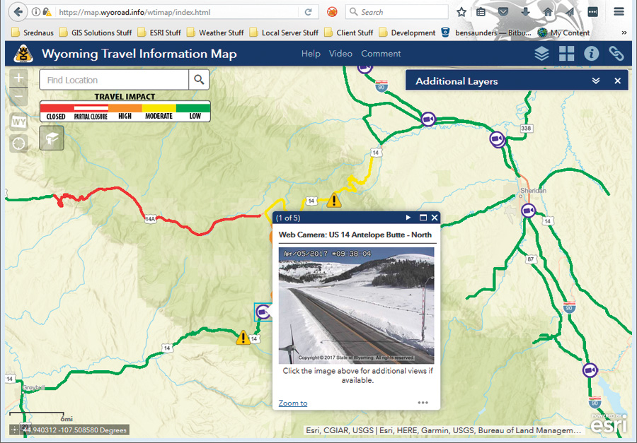
Truckers, tourists, and locals alike can now navigate Wyoming’s often unpredictable highways and byways with the help of real-time information from the Wyoming Travel Information Map, built by the Wyoming Department of Transportation (WYDOT) using Web AppBuilder for ArcGIS. On an average day, the map gets about 170,000 visits—and that number can climb to four million when there’s a big storm.
“Road condition information in Wyoming is critical to safety,” said Vince Garcia, the GIS/ITS program manager for WYDOT. “Wyoming gets severe winters with a long duration. We have the worst blowing snow conditions in the country.”
WYDOT created the Wyoming Travel Information Map largely to help drivers plan their travel before they set out on the road.
“Without this map, people coming from other states may not be well prepared,” added Garcia.
The interactive map displays the state’s current road conditions, construction areas, and advisories. Other map layers include web cameras on certain parts of the highway, rest area locations, size and weight restrictions, weather stations, truck parking areas, and the locations of variable speed limit signs.
With so many elements in one map, WYDOT didn’t want to have to build things from scratch.
“We preferred to configure instead of code and customize or extend where we [needed] it,” said Ben Saunders, a GIS professional with Srednaus Mapping, which worked with WYDOT to build the Wyoming Travel Information map. “The functionality of Web AppBuilder is ready out of the box, [and] Esri’s help documents and the user community gave us the confidence that we [were] working within a well-documented environment.”
Web AppBuilder for ArcGIS features ready-to-use widgets, configurable themes, and custom app templates. Apps can be hosted online or run on an on-premises server. And the HTML/JavaScript apps that it builds are responsive and intuitive.
“We wanted this map to be mobile friendly, and [we] liked that Web AppBuilder offers a responsive design,” said Trenton Rawlinson, a GIS developer with WYDOT. “We also wanted to make the initial download smaller so people can access it when there is limited Internet service. We used image caching versus feature services to make it load more efficiently.”
Although during development, WYDOT created several iterations of the map, the basic process of building it took just three days. After tuning up its performance, administering user testing, and working through network issues, the WYDOT team delivered the Wyoming Travel Information Map to the public within six months of conceiving the project.
“There’s no way we would have been able to put this together using the old technology,” Garcia said. “Some of the lessons learned led directly to more efficient development of subsequent maps for the Wyoming Department of Tourism. And the platform allows us to add additional functionality and data, like National Weather Service radar loops. The application can continue to evolve.”
For more information about the Wyoming Travel Information Map and how it was built, email wyoroad@wyo.gov.