The 3.14 version of the ArcGIS API for JavaScript adds more than 30 new classes, dozens of bug fixes, and other enhancements to the API. Let’s take a look at some of these new features.
Renderer Enhancements
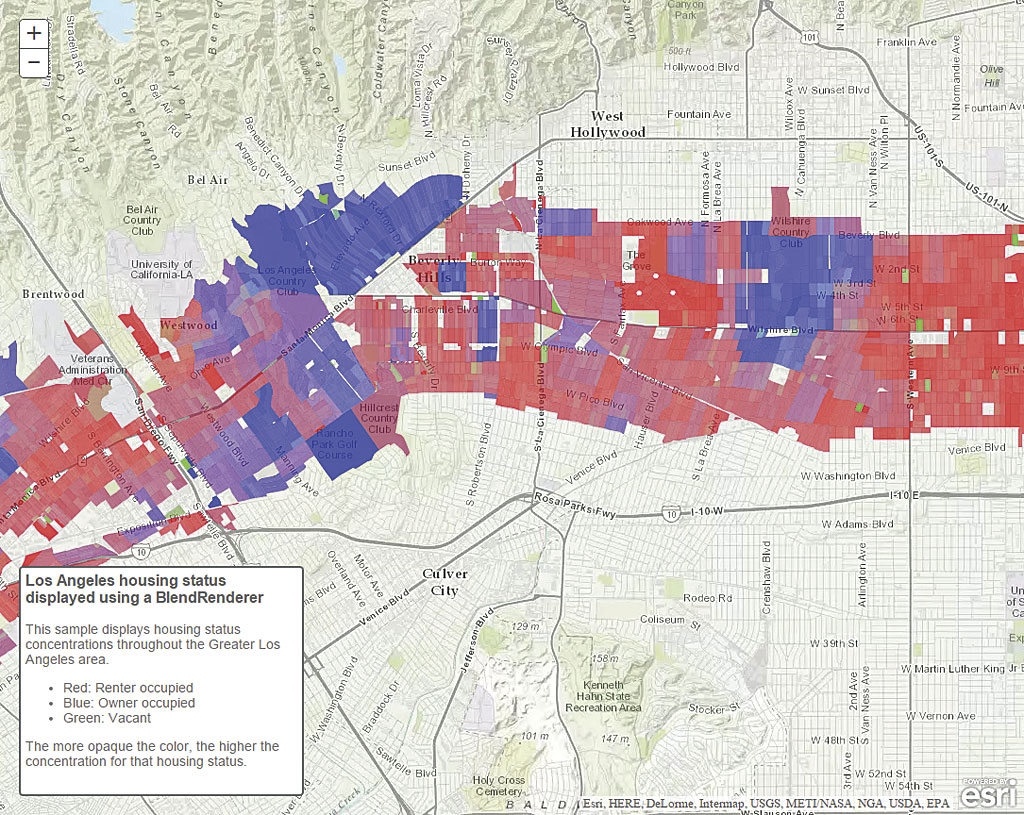
Several renderer enhancements were made to the API including scale-driven sizing for polygons and their outlines when calling smartMapping.createSizeRenderer(). Also, the new BlendRenderer class (beta) was added to the API, providing another option for visualizing complex spatial patterns in your data. BlendRenderer allows you to easily identify the predominant attribute among two or more competing attributes of a feature and visualizes the strength of that predominance using blended colors.
In the map in figure 1, blue features represent areas that predominantly contain owner-occupied housing, while the red features are mostly composed of renter-occupied housing units. Areas shaded with a light purple color, however, are composed of a near-even mix of owner-occupied and renter-occupied housing units. Thus, areas with a high occurrence of one attribute will be rendered with strong opposing colors (in this case, blue or red), while areas with nearly equal occurrences of the opposing attributes will blend the opposing colors (in this case, purple). For more information on how BlendRenderer works, see this topic in the API reference and explore the new samples that use it.
New Widgets
ElevationProfile (beta) and LayerList (beta) are two of the widgets added in this release. The ElevationProfile widget allows you to view the elevation profile along a line feature. The LayerList widget provides a convenient way for users to toggle layers on and off.
WFS Layer Support
The Open Geospatial Consortium, Inc. (OGC), Web Feature Service (WFS) interface standard provides an interface allowing requests for geographic features across the web using platform-independent calls. The newWFSLayer (beta) adds support for OGC WFS.
API for Image Services Enhancements
New measuring capabilities have been added to the API for Image Services. The ImageServiceMeasure widget and ImageServiceMeasureTool, for example, allow you to measure areas, perimeters, distances, and angles in image services. TheObliqueViewer widget allows you to view image services from oblique views, which minimizes distortion. It also lets you observe the same imagery from different angles. RasterLayer and PixelBlock are no longer in beta.
Extending Operations Dashboard
Developers and partners can write new widgets, map tools, and feature actions for Operations Dashboard for ArcGIS using ArcGIS API for JavaScript. Administrators can add extensions to their organizations for publishers to use inside their operation views.
DataReviewer Classes
The new DataReviewer classes allow you to take advantage of ArcGIS Data Reviewer for Server tasks that add data quality control features to your application. Some of these features include automated data validation using rules authored in ArcMap, data quality tracking and reporting, and an iterative correction process.
All the Details
See a complete list of the improvements and bug fixes, as well as additional information about upgrades to other resources, in the What’s New in Version 3.14 Guide topic in the online help.