Creating an ideal relationship between man and nature
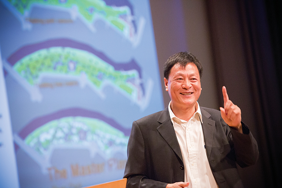
Kongjian Yu, the keynote speaker at the 2014 Geodesign Summit, January 29–30, 2014, in Redlands, California, is the son of a Chinese farmer. He grew up on a commune working in the fields with his father until he left for college at age 17. Today Yu, 50, is a well-respected, award-winning urban designer and landscape architect. His firm, Turenscape, turns neglected land and polluted waterways into wetland parks filled with flowers and teeming with fish and birds.
Yu showed photographs of these lush parks during his address. He urged adoption of a fresh way of thinking about landscape architecture and design. He advocated using geodesign, which incorporates design, geography, and geospatial technologies such as GIS, to help create an ecological infrastructure for communities.
An ecological infrastructure reflects the natural environment rather than something built out of concrete and steel. Many of Turenscape’s park projects in China let nature take its course. Rather than diverting storm water from a river during the rainy season with pipes or channels, it’s captured and filtered in ponds in a terraced wetland system. Areas that flooded historically are allowed to flood again. Nature takes hold and reeds and flowers spring to life. Birds flock to these wetlands again and so do the bird watchers, Yu said.
“Design for an ecological infrastructure to create an ideal relationship between man and nature,” said Yu. “It’s a new way to make a beautiful landscape.”
Geoempowering Design
Yu and a roster of other speakers gave presentations to nearly 300 people from diverse fields such as architecture, urban design, ecology, health, banking, biology, mining, and marine science. Nearly half were new to the event, now in its fifth year. Geodesign Summit organizers believe this reflects a deepening interest in geodesign.
Emcee Thomas Fisher, dean of the College of Design at the University of Minnesota, said the definition of geodesign continues to evolve but offered one of his favorites. “It’s a marriage of the incredible spatial power of GIS, geography, and design. It marries the data-rich analytical power of GIS with the creative synthesizing methods of design. GIS helps us understand what is and design what could be.”
Esri president Jack Dangermond spent about 30 minutes outlining why he thinks using geodesign—whether in urban planning or other fields—will be a linchpin in solving sustainability issues including the effects population growth are having on land use and climate. “What is the counterbalance to these trends?” he asked. “I think it’s in this emerging world of geodesign. Collectively, we need to create a better future.”
Dangermond said GIS technology is essential to geodesign. “GIS provides a platform for the integration of science, providing the practical means for geoempowering design.”
Esri staff gave a short demo of the geodesign tools in Esri CityEngine, which creates 3D models of buildings and entire urban landscapes using procedural rules. Eric Wittner, Esri 3D technology evangelist, and the 3D team also previewed the 64-bit ArcGIS Pro, a powerful 2D and 3D visualization, editing, and analysis application that will be part of ArcGIS for Desktop. The first release of ArcGIS Pro is slated for later this year and will mainly offer 2D and 3D visualization, support for analysis, and simple feature editing. Subsequent releases will offer additional capabilities.
Esri technology evangelist Bern Szukalski demonstrated a new browser-based web app called Esri Landscape Planner that will be available soon in ArcGIS Marketplace. This ArcGIS Online powered app contains sketching and analysis tools and gives designers the ability to bring in landscape and demographic layers and imagery. The app also lets them collaborate and edit designs. Szukalski used the app’s tools to sketch a park and a proposed light-rail line in a town. “I think this will be an exciting piece of technology to add to your geodesign portfolio,” he said. “Landscape Planner helps put all the pieces together to create a true, open geodesign platform.”
Designing with Nature in Mind
Though technology was front and center at the conference, the idea of designing with nature in mind was omnipresent. Renowned biologist and natural sciences writer Janine Benyus took the stage to talk about biomimicry, the science that studies how nature can provide inspiration for innovation. It can provide a model for landscape and urban design.
“I live in the Bitterroot Valley in western Montana,” she said, showing pictures of the bucolic rural countryside. “It’s so healthy . . . when I walk back there, I see what we could be,” she said.
Benyus said much can be learned from nature about how to design for urban areas. “It’s nature as mentor,” said the author of the book Biomimicry: Innovation Inspired by Nature. “What would it take for a city to function as elegantly as a forest?”
She spoke about how plants and animals adapt to a changing and often harsh environment, using a 1,500-year-old tree with strong, deep roots and branches that are designed to shed as an example of the resiliency in nature. “That 1,500-year-old tree—it has seen many hurricanes,” she said. “Generosity is one of the standards of nature. How does nature create more and more opportunities for life?”
In a follow-up conversation with Dangermond and Fisher, Benyus said that metrics need to be collected to create ecological performance standards for designing sustainable cities. She envisions the creation of a biological information repository that inventors, designers, and others involved in biomimicry could access to obtain information about their areas of interest. Benyus said she looked forward to learning more about GIS and the role it could play in developing and hosting such a repository.
The Art of Survival
Keynote speaker Yu learned to use GIS two decades ago. Today his staff at Turenscape uses ArcGIS for topographic modeling and analysis. Before he founded Turenscape in 1997 and became professor and dean of the College of Architecture and Landscape Architecture at Peking University, Yu attended Harvard University, where he earned a doctor of design degree at the Harvard Graduate School of Design. He also interned at Esri, where he worked in the prototype lab.
Yu said geodesign using GIS technology is essential to the work of his company, which has completed 1,300 projects in 200 cities including China Town Park in Boston. But he credits his early years working on the commune with providing him a grounding in geography, topology, and soil. The words Tu Ren in his company’s name, Turenscape, mean “earth man.”
The man did not really wander far from the farm. “Many of these designs are inspired by my experience on the farm,” said Yu. “In the city, you don’t know how to grow rice. You don’t know how to work with dirt, you don’t know how to irrigate.”
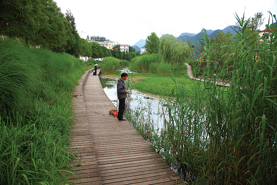
He said he and Dangermond are sympatico when it comes to believing that geodesign will change the world for the better and our survival depends upon it. For example, geodesign was used for the Shuicheng River and Minhu Wetland Park project his company worked on in Liupanshui City, China. There, storm water is no longer diverted away from the river. Water no longer goes to waste. A once-polluted waterway is fishable again. People stroll along walkways that wind around terraced ponds. Beautiful orange flowers blossom around the wetland’s perimeter.
“Now, it’s become a beautiful place,” said Yu. “People love it. The biodiversity has increased. It has now become a national wetland.”