The GIS team for the Regional Municipality of York (York Region) implemented new image mosaic capabilities using ArcGIS 10 to create mosaics more efficiently while improving the accessibility of information for organizations across the region.
Located just north of Toronto, Ontario, Canada, the Regional Municipality of York is a diverse area of 1,756 square kilometers (678 square miles). The region’s Geographic Information Services Branch (GIS Branch) works with nine local municipalities, two conservation authorities, and two school boards and their respective GIS staff, to provide services to their organizations. The management and delivery of imagery/raster datasets for the region are the most demanding services the GIS Branch provides. This imagery is used for location visualization, work planning, and emergency management and dispatch support, among other business processes.
The GIS Branch serves a variety of spatial data and services to more than 330 desktop GIS users and thousands of visitors to the region’s internal and external website. For raster data, the GIS Branch manages:
- Three catalogs
- 16 regional coverage datasets
- 13 orthophotography datasets
- Multiple years of imagery collections from 1995–2012
Orthophotography is also widely used. Each year, the GIS Branch collects 275 MB to 416 GB in orthophotography (depending on the resolution and number of images) and manages two terabytes of orthophotography data, ranging in date from 1995 to 2012 with resolutions of 3 cm to 50 cm. The use and transfer of massive files associated with spatial raster data, such as orthophotography, can grind the region’s network and all the workstations on it to a halt.
Raster Mosaics Had Shortcomings
To help address this issue, the GIS Branch implemented the use of tiling and image mosaics. While some improvements to network and workstation performance were realized, the introduction of tiling and image mosaics introduced a new set of challenges.
Duplication became an issue. The individual tile TIFF images were stored on the file server, while the raster mosaic was stored on a separate ArcSDE instance in Oracle. This doubled the disk space required to 4 terabytes and necessitated a separate instance of Oracle.
Image file size became another issue. The oldest imagery was not available to ArcGIS desktop users because its inconsistent image file sizes (length and width) would not mosaic into ArcSDE. The time required to create a raster mosaic of the region was at least 24 hours, and another 24 hours was needed to run pyramids and statistics on the mosaic. Prior to running the process, a GIS technologist would spend about 7 hours writing and testing the scripts and then several more hours monitoring the process and testing the result.
A New Approach to Mosaic Datasets
Given these challenges, the GIS Branch identified the need for a new approach to creating mosaic datasets. The branch believed that the mosaic dataset available at ArcGIS 10 could help solve the storage space and time problems. To quickly familiarize staff with the new technology and ensure proper implementation, the GIS Branch sought assistance from external resources. The deliverables defined included an environmental scan of the current raster data management technologies and emerging trends, implementation of a best practices solution, and technology transfer to regional staff. Over a period of two months, 43 North GIS Consulting Inc. worked with staff to reach these goals.
The new mosaic datasets method is easy. It is completed by one person with the process running in the background during a workday on an average high-speed computer and without special software. Having one person create the mosaic dataset without the assistance of the database administrator reduced staff time. There are no scripts to write or Oracle work required.
Creating the mosaic dataset takes seconds, while adding the raster files only takes a few minutes. The bulk of the process (about 2.5 hours) involves building overviews for the 1,100 images that cover the region. Compared to the previous process, which took two days to mosaic the images, build pyramids, and run statistics on the mosaic, the new mosaic dataset delivers substantial gains to the GIS Branch and, in turn, the region.
Images are available in an enterprise geodatabase less than two days after they are received rather than taking more than a week. The new mosaic dataset also eliminates approximately 2 terabytes of storage from data duplication, as well as the need for an additional Oracle instance.
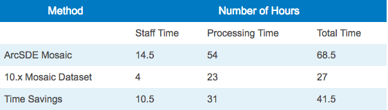
In the proof of concept, one orthoimagery collection was processed using both the old and new methods and the times logged in the table shown in Figure 1.
Access to Data That Was Previously Unavailable
The mosaic dataset in ArcGIS 10 allowed the region to publish MrSID images from 1995 into the enterprise GIS database environment. These images were not previously available as a mosaic due to different sizes of the image. MrSID images had been stored offline and were not accessible to GIS users throughout the region. This historical data is valuable and frequently requested by departments in the region.
Imagery in multiple resolutions can now be used in one mosaic dataset. While the region generally only has one resolution per year, some years have strips of higher resolution imagery. These are now part of a mosaic dataset along with the lower-resolution data. Users see either the low- or high-resolution imagery, depending on the zoom level.
Another advantage is the mosaic dataset footprints can be manipulated by removing unwanted pixels (commonly the black pixels found at the edge of images that have been clipped). This is done by re-creating the overviews with just those images with black areas selected in ArcMap. This lets the user only see what they need and eliminates areas with no value.
Highlights of the Mosaic Datasets Method
The new process was tested in January 2013 and implemented in March 2013. The new method to create a mosaic dataset was then transferred throughout the region. The new solution enables the creation of a high-performance regional mosaic 40 hours sooner than the previous method. This new method:
- Provides access to new types of imagery files and historical information.
- Needs half the storage space.
- Streamlines processing and eliminates the need for multiple technicians to manage the mosaic.
While the region’s new mosaic datasets method clearly delivers time and storage space savings to GIS staff across the region, its true value is the increased access to data that it delivers. Decisions affecting development, utilities, water and wastewater, education, transportation, and others, benefit from access to current and historical imagery. By providing access to mosaic datasets, GIS staff can now help to support these critical decisions and the timely delivery of services across the region.
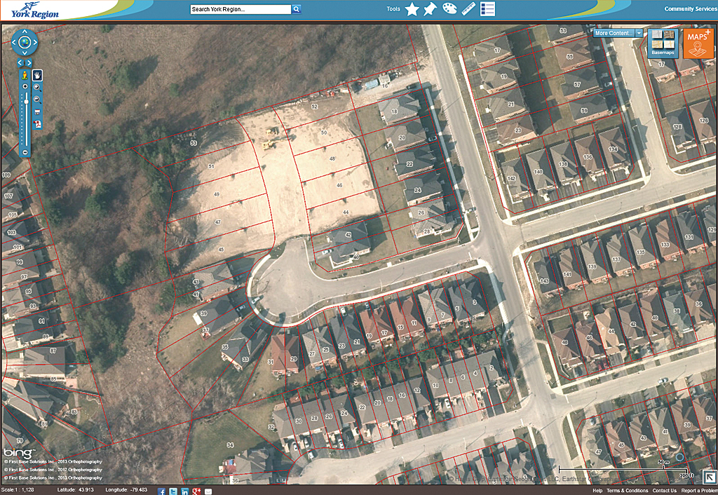
To see the region’s orthophotography, visit www.YorkMaps.ca.
About the authors

Peter Simmons