|
|
||
|
|
|
|
|
|
Aerial Photographs Are Far More than Pretty PicturesDigital Orthophotography Boosts Scottish Maintenance ProgramSouth Ayrshire Council, with its administrative center in Ayr, governs a mainly rural region measuring 422 square miles located in southwest Scotland. About 115,000 people live here in a jurisdiction extending from Troon in the north to Ballantrae in the south, including the towns of Ayr, Prestwick, Maybole, and Girvan. The area is one of the most attractive in Scotland with a rugged landscape and seascape, steeped in history and culture, and boasting numerous golf courses including the world-famous Royal Troon and Turnberry. The council's Department of Parks and Environment is responsible for the region's parks, ground, and open space including eight golf courses. Their priority is to create an inventory of all assets connected with these grounds, including features such as flowerbeds and golf course bunkers, with a textual description of their location. Such an inventory helps the department to maintain assets in the most cost-effective way.
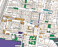
Before GIS, the department relied on five-year-old paper maps that assigned locations of assets by a reference number and provided annotation about them. These maps did not include the position of all assets or their exact location. As vague as these documents were, the time required to prepare them was enormous; each site was captured by traditional field survey methods by a team of five to seven people. The information was then transferred onto paper copies of Ordnance Survey (OS). Each site was then hand-drawn, labeled, and painstakingly colored, uniquely if possible, for both the site and the label. These maps were then color photocopied/reduced and cataloged by contract. The cumulative time, from initial survey until all the plans were produced and issued, was one year. However, more time was spent making changes to a plan with the master map being updated, recopied, reduced, and reissued. When the survey team was reduced to one person, a more effective way of managing and maintaining the information had to be found. GIS Enters the PictureArcView GIS was introduced to South Ayrshire Council in late 1996, and the Parks and Environment Department was an early adopter. The department's management was excited to improve how Business information was stored and maintained and felt that the core capabilities found in ArcView GIS offered a better way than paper maps. As a first step, the information from the paper maps was transferred into the GIS. One person undertook this task, digitizing and quality checking more than 3,000 quite complex polygons over a few months. Each polygon was given a unique identifier, allowing it to be linked to the existing asset database. Maintaining Look and FeelThe other deliverable at this stage was an enhancement that exactly replicated the hand-colored maps. As is often the case in the implementation of new GIS applications, users still craved the appearance and style of paper maps. To satisfy this, a layout generation routine was developed that uniquely colored each site, labeled it with the same color as the polygon, and masked the label to make it more legible. The efficiency savings of such a routine over the previous method of map production became quite obvious, and this was an early success for the GIS. Getting the OverviewAt this stage, the information in the GIS was quite coarse. ArcView GIS could outline a site for a user and return the information about it in a dialog from the external asset database. What was missing was the fine detail about all the features within these sites—in other words, the "what and where" of each asset. The obvious way to capture this type of information was with a traditional field survey. For the areas being targeted, however, increasing the amount of spatial information being recorded would have been expensive and time-consuming. Furthermore, the small department could not afford to assign more than two full-time workers the task of capturing more than 15,000 assets. What was needed was a more cost-effective and less resource-intensive way to collect the same information.
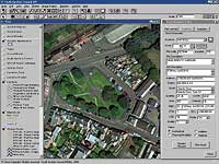
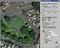
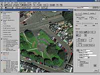
Digital orthophotography, which uses aerial photography to deliver highly accurate digital data, was the obvious solution. The department further decided to capture data in only the large urban areas of the council's jurisdiction, as more than 85 percent of the council's assets are located in these areas. These factors meant that it would not be cost-effective to photograph the remaining sparsely populated areas, hills, forest, and moorland. And the DetailsAn ArcView GIS application was now needed that would get as much information as possible out of the images. The on-screen data capture tools used within the council, although adequate in certain circumstances, did not have the image processing functionality required. The council determined that ArcView Image Analysis, an ArcView GIS extension, developed by ERDAS in collaboration with Esri, would provide enhanced data visualization and semiautomatic data extraction/creation and analysis. This function greatly improved the productivity of the small data capture team. ArcView Image Analysis also came with its own Avenue requests so frequently performed tasks could be automated, again to the benefit of the data capture process. Getting to WorkTo capture an asset, the user first specifies the town he wants to work in. All the undigitized assets are selected, and the first asset is displayed in the dialog. The user then clicks on the zoom button to redraw the view, centered on the selected site. Next, by clicking on the View Controls button, the editor functionality is displayed and the site can be captured using either standard on-screen digitizing tools or ArcView Image Analysis. To complete the capture process, the feature is linked to its record in the database using another button on the dialog. At this stage the user can set both a status flag and confidence flag for the feature. A confidence flag is necessary as the photography was flown in high summer with a lot of tree and shrub cover. In some instances the user cannot fully guarantee that what he has digitized is 100 percent accurate, so he can set a confidence flag against it. These flags will allow for a more targeted ground-truthing program at a future date. At this stage, the user also has the ability to update the record for the asset in the database. Once this process is complete, the user moves on to the next asset and begins again. The department expects the data capture phase of the project to be completed during 2000 and will then turn its efforts to data maintenance. Looking ForwardWith these tools in place, the Parks and Environment Department has moved rapidly from simply coloring in maps to complex data capture and image processing using digital orthophotography. This photography, in conjunction with ArcView GIS and the ArcView Image Analysis extension, is being used to build a baseline audit of all assets connected with the department's grounds maintenance function with real Business information being extracted easily and efficiently. The creation, management, and maintenance of these maps let the staff concentrate on other, perhaps more needed services. In addition, the whole department can access the image maps. The department is using a United Kingdom-specific variant of ArcExplorer called Map Explorer to open the data to other users in the department for viewing. It has also recently added ArcIMS and sees this as a way in the future to serve the imagery, maps, and database information. This effort proves that aerial photography goes far beyond being a pretty picture, providing information that delivers key Business benefits to an organization that, using a GIS, can provide resource and efficiency savings. For more information contact Stewart McCall, GIS coordinator, South Ayrshire Council, Ayr, Scotland, United Kingdom (tel.: 44-1292-612733, e-mail: stewart.mccall@south-ayrshire.gov.uk). |