


|
|
||
|
|
|
|
|
|
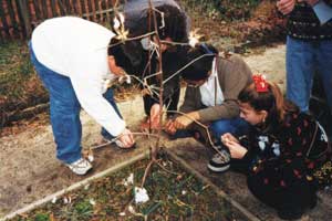
Documenting a CultureBy Marsha Alibrandi, North Carolina State University, and Ann Thompson and Rita Hagevik, Ligon Middle School, Raleigh, North Carolina As buses were pulling away on that last day of school in 1998, a huge bulldozer knocked down two 60-foot willow oak trees to make way for a new building. "If only trees could talk!" lamented one of the teachers. The trees stood as living monuments to J.W. Ligon High School, which opened in 1953 and was the premier African-American high school in Raleigh, North Carolina. Located in a traditionally African-American neighborhood, Ligon became the center of the African-American community and a great source of pride. In 1971, at the height of desegregation, Ligon became a junior high school in the consolidated Wake County Public School system. Today the building is the home of a magnet middle school. For years, an active alumni association from the African-American community has kept the memory of Ligon High School alive. A feeling of resentment, symbolic of all that was lost during desegregation, continues to be associated with the building that now houses the magnet school. The felling of the huge willow oak trees, symbols of stability and permanence, mobilized teachers and spurred collaboration with Ligon alumni to document the The felling of the huge willow oaks was a blow to the community and the trigger for the project. Above right, students and teachers nurture a new beginning. Ligon History ProjectLigon High School alumni, the school's teachers and students, university faculty, graduate students, and community partners collaborated on the Ligon history project. The project's mission was clear: identify, locate, document, and showcase the remarkable chronicle of Ligon High School. Middle school students in journalism, history, science, and GIS classes would re-create a virtual history of the school, integrating traditional research methodologies, such as interviewing, data collection, and archival research, with technologies such as GIS and the Internet. The overwhelming scope of this task became apparent when it was discovered that many records and archives from the original school, like those of other large urban districts, had either been lost or destroyed during the desegregation period. The goal of the Ligon history project was to immerse students in a real-world learning experience that included historical data, maps, and archival records. Middle school teachers Ann Thompson and Rita Hagevik, along with North Carolina State University Professor Marsha Alibrandi, agreed that ArcView GIS would be an ideal tool to support the project. GIS maps of Raleigh during the 1950s, 1960s, and 1970s were prepared to tell the story from an African-American perspective. The project coordinators' initial challenge was to determine how GIS could be used to represent historical events, how an undocumented history could be graphically represented using GIS for later display on the Internet, and how GIS could integrate quantitative data with archival and qualitative interview data to tell a story. On a field trip to the City of Raleigh's GIS office, students learned about the powerful adaptability of GIS. They observed state legislators using this technology to weigh different scenarios before reaching complex spatial decisions. When students were shown an annexation map illustrating the growth of the City, they realized that ArcView GIS was a tool that could help them to analyze and illustrate changes that occurred in the Ligon area from the late 1700s to the present. The Role of GISAt the project's kickoff, students had armfuls of maps provided by the State Archives and a set of base layers for their ArcView GIS database. Annexation boundaries, Wake County streets, and downtown and southeast Raleigh land parcels were made available to the project by the Raleigh GIS office. Wake County GIS provided census tracts and public school data. A sense of panic, however, developed when it occurred to students and facilitators that all of this data represented Raleigh in just one year, 1999. Information overload was as much of a stumbling block as were information gaps. A new action plan emerged that scaled back the original scope of the project. After gathering the relevant data layers, students conducted intensive historical research. Students read transcripts of oral history interviews of alumni conducted by journalism classes. They analyzed old school yearbooks and local history books. They generated a list of buildings that were important to Ligon's history. Graduate students from the local university gleaned data from the State Archives. New themes were added to the GIS for this researched information, color-coding was used to visually represent segregated areas, and hot links were created to pictures from the State of North Carolina Archives collection. GIS students also learned interview techniques that they used when speaking to elder alumni. The intergenerational aspect of the project had a magnetic effect; students were learning history from those who had lived it. Life MapEducators coined the term "Life Map" for the historical representation
Above right: Ligon History Project Life Maps illustrate graphically, temporally, and spatially a person's journey through life. Students completed two additional ArcView GIS projects using historical maps provided by the State Archives. They created basemaps for a Railroad Development GIS project and a GIS Greater Raleigh Trolley Tour and Web site project. Photos of historic buildings were linked to these GIS maps. For more information about the Ligon History Project please visit their Web page at www2.ncsu.edu/ncsu/cep/ligon/about/history/intro.htm. This article has been adapted from the Esri Press book GIS in Schools (Item Number 85177, ISBN 1-879102-85-4, 145 pages, $19.95) by Dr. Gail S. Ludwig and Dr. Richard H. Audet. The book includes a CD-ROM of educational resources, GIS software, GIS based learning activities, and the Esri videoclip "Geography Matters." To order this and other Esri Press titles, visit www.esri.com/esripress or call 1-800-447-9778. |
 school's history. Teachers were optimistic that lessons from these rich historical accounts would guide the future of the new school and restore its status as a community center and source of pride for alumni. They also hoped that students would be able to draw strength from the school's rich cultural tradition and appreciate more profoundly their heritage and place in the Ligon community.
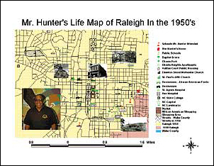 of an alumnus' life space during Raleigh in the 1950s. The map included