


|
|
||
|
|
|
|
|
|
Interactive Maps Enhance Pacific Disaster ManagementHurricanes, typhoons, tidal waves, volcanic eruptions—these are among the most The destructive power of most of these events is augmented even further if people do not know they are coming. The absence of warning is a special problem for those in and along the coast of the Pacific and Indian oceans—Russia, Japan, China, the Philippines, India, Bangladesh, and Hawaii, to name only a few—because the lack of land in the middle of the ocean translates to few ground-level reports. Vulnerability of the Pacific OceanUnfortunately, plate tectonics and global air circulation patterns make disaster management important in that region, especially the west Pacific. Plate boundaries Above right: Satellite image of the Pacific Ocean for July 6, 2000. Two storms are of interest to those in the western Pacific: typhoon Kirogi east of Japan and tropical storm Kai-Tak northwest of the Philippines. Establishing an Emergency Management Web SiteIn FY 1995, after Hurricane Iniki caused $260 million in damage to Hawaii, Congress authorized the funding for a Pacific Disaster Center (PDC). The PDC is located in Hawaii and supports federal, regional, and international emergency managers along the Pacific Rim by providing high-quality, timely imagery, maps, and other value-added information products about natural and human-induced disasters, including hurricanes, tidal waves, floods, and earthquakes, via the Internet (www.pdc.org). PDC and the Global Disaster Information Network InitiativeThe PDC also plays a vital role in the Global Disaster Information Network (GDIN), a network President Clinton established in June this year by executive order. The GDIN initiative is designed to facilitate the sharing and use of information among regional, national, and international emergency management organizations. Current EnhancementsThe maps and images on the PDC site provide a lot of information, but the maps are static, and in March of this year the PDC contracted with Esri to implement dynamic mapping. When the first phase of the project is finished, the person who reports an event to the PDC (who is called the point of contact, or POC, and usually belongs to a fire department or other local emergency response team) will be able to indicate the location of an event by clicking a point on a map. Future PlansThe resulting information becomes available immediately to everyone with Internet access, so point locations alone are significant, but the plans for the future are even more substantial. They call for enabling qualified POCs to draw line and polygon features on maps and satellite images. A member of a fire department could show the movement of a wildfire by drawing a series of polygons on a map, for example, and a meteorologist could predict a storm track by drawing a dashed line on a satellite image. Enhanced maps and images like these are already being displayed on the PDC Web site, but they can only be produced by the PDC itself. Local emergency response teams all over the Pacific are authorized to report events, so enabling them to modify maps and images as well will vastly increase the amount of information available for emergency management. ImplementationThe PDC has facilities on Oahu and Maui that are connected with core emergency managers via a wide area network. When the new capabilities are implemented, both facilities will have ArcIMS map servers running on the existing UNIX platforms, ArcSDE Oracle data servers, and Windows application servers. Java and JBuilder are being used to program the site and its new mapping functions. For further information, please contact Mr. Joseph Lees, director, Pacific Disaster Center (tel.: 808-891-0525, fax: 808-891-0526, e-mail: jlees@pdc.org) or Craig Chellis, deputy director (e-mail: cchellis@pdc.org). |
 powerful, and feared, of natural events.
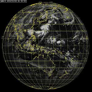 surround the Pacific Ocean, making the coastline (sometimes called the Rim of Fire) prone to volcanoes, earthquakes, and tidal waves; the warmth of the west equatorial Pacific provides enough energy for hurricanes; and winds in the Northern Hemisphere push hurricanes and other storms north, where they sometimes go ashore. The death and destruction that result are almost unimaginable. A storm that passed over Hong Kong in 1906 left 10,000 dead; one that crossed the Philippines in 1952 left 10,300 dead; and one that crossed Bangladesh in 1970 left 300,000 dead.