
A Framework for Understanding, Managing, and Improving Our World
The theme of the 2007 Esri International User Conference was GIS and the Geographic Approach. This article is an abbreviated synopsis of the opening session, covering the context and trends of GIS as well as many of the software development efforts that will be part of the 2008 ArcGIS 9.3 release.
Context
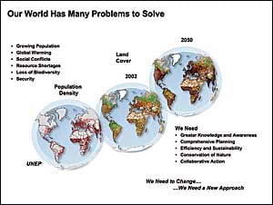
Today we live in a world with many problems, including growing population, global warming, social conflicts, resource shortages, and loss of biodiversity. The complexity and severity of these problems are increasing, suggesting a challenging future for society. Clearly we need more knowledge and awareness of our situation. We also need more comprehensive approaches to how we design and manage human activities—approaches that consider and account for the impacts of our actions and guide us to a more sustainable future.
Geography, the science of our world, coupled with GIS is helping us understand the Earth and apply geographic knowledge to a host of human activities.
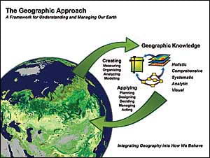
The outcome is the emergence of “the geographic approach”—a new way of thinking and problem solving that integrates geographic information into how we understand and manage our planet. As the diagram below suggests, this approach allows us to create geographic knowledge by measuring the Earth, organizing this data, and analyzing/modeling various processes and their relationships. The geographic approach also allows us to apply this knowledge to the way we design, plan, and change our world.
The geographic approach is not a new idea. It is how geographers study and analyze our world. It was perhaps best articulated by Ian L. McHarg in his book Design With Nature, where he lays out a philosophical context for why and how humans should manage these activities within natural and cultural landscapes.
GIS Applies the Geographic Approach
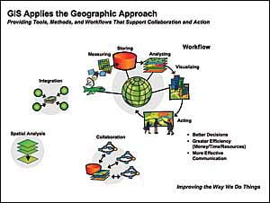
GIS is an information system technology with geography at its core foundation. GIS provides technology and methods for data integration, spatial analysis, and collaboration. GIS also provides a science-based framework for organizing workflows that integrate all the factors that need to be considered for decision making. GIS improves the way we do our work by facilitating better decision making; saving money, time, and resources; and allowing us to more effectively communicate through geospatial visualization.
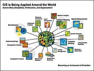
Today GIS is being applied around the world to virtually all the problems that we face. The sheer number of applications suggests it is becoming a major instrument for human understanding of how we increasingly impact and evolve the planet. While some of these systems are focused on automation of technical workflows, such as cartographic production and image analysis, other systems organize society’s key information systems, such as cadastral systems, national security, facility management, resource management, and land-use planning. Still others emphasize decision support for site selection, logistics, and natural resource management.
GIS Implementation Patterns
GIS is being implemented in three common patterns: desktop, multiuser/server systems, and federated systems.
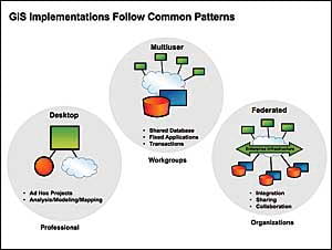
The desktop pattern is commonly used by the geospatial professional who performs ad hoc projects, such as data creation, mapping, spatial analysis, and modeling.
The multiuser pattern is a system with a common centralized database shared among a group of users. There are many examples of multiuser systems at both the department and enterprise levels. Generally, these systems involve fixed applications that use a geodatabase within structured workflows. These systems also organize and manage changes to the database as specific transactions (e.g., land record updates, facility changes, zoning changes). This type of system is typically implemented using client/server architecture.
As standards for Web services have advanced, users have started to implement federated systems using service-oriented architecture (SOA). Federated systems use Web services as a framework to support applications that integrate data and services that are being maintained in different distributed systems.
This architecture allows information from different systems (e.g., planning, engineering, and surveying) to be dynamically shared and integrated as if the data were in a single database. SOA also allows users to easily integrate GIS services with other IT systems (e.g., ERP, CRM, etc.).
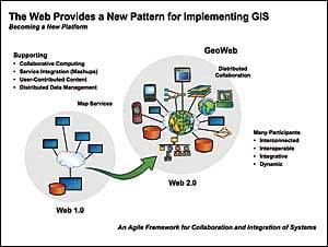
While nearly all GIS implementations follow one of these three patterns, the Web is emerging as a new platform for certain types of applications. The Web doesn’t replace the other three patterns; it extends the federated pattern, implementing many GIS concepts and ideas in the Internet environment.
GIS mapping was first introduced on the Web in the mid-1990s as an online map service. This has been described as the Web 1.0 environment, where one server (e.g., ArcIMS) “broadcasts” map services to many clients. Today there are thousands of map servers on the Internet serving hundreds of millions of maps each day.
The Web 2.0 environment (the world of Web services) enables many new opportunities to use GIS, including collaborative computing, integration of user-contributed content, mashups, and shared distributed data management.
While performance, security, and interoperability issues still remain, this style of architecture promises to extend the reach of the geographic approach to everyone—creating a societal GIS environment.
Esri continues to evolve its technology to support the Web 2.0 architecture that is now becoming available for both Internet and intranet environments.
Enabling Technology
The enabling technology for building GIS is evolving with faster, cheaper, and smaller machines; increased bandwidth and storage capacity; integrated mobile technology; Web services standards; and real-time sensor networks. The Web is also providing the ability to easily integrate multiple services, creating new opportunities for collaboration.
GIS software is also evolving rapidly—becoming services oriented. This means GIS functionality resides on a server platform capable of leveraging the full Web 2.0 environment. In conceiving the future of GIS technology, Esri is engineering our software so it takes advantage of this powerful platform and at the same time supports users’ current needs.
ArcGIS
ArcGIS is our main focus and is how Esri supports GIS users. ArcGIS is a complete and evolving geographic information system with three key components: ArcGIS Desktop; ArcGIS Server; and ArcGIS Online, a new online component.
While the desktop system is powerful in its own right, it also works as part of an integrated client/server system. ArcGIS is designed so that users can author data, maps, and models at the desktop and put them onto a server for easy-to-use access by virtually any type of client, including Web browsers, mobile devices, geobrowsers, and desktop applications. These client applications can also request maps, analysis, and visualization services to be done on the server.
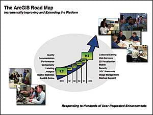
ArcGIS 9.2, released last year, represents more than 1,000 person-years of engineering and development and has added many new capabilities. We are currently working on ArcGIS 9.3, which will include many improvements. This version will be released in 2008.
At the same time, Esri has embarked on a new method of releasing its software through service packs. For example, ArcGIS 9.2 Service Pack 3 included the new functionality of ArcGIS Survey Analyst 9.2 with the new cadastral editor. These service packs are released approximately once each quarter and provide many incremental software quality improvements as well as new user-requested enhancements. So far this year, there have been four service packs, providing our users with rapid access to our engineering team’s efforts.
The ArcGIS 9.3 release will focus on quality and documentation, as well as provide hundreds of new capabilities. Some of these are described below.
Improving Geographic Science, Scripting, and Model Building
ArcGIS 9.3 will introduce a number of new tools to do geographically weighted regression analysis. These enhancements to the geoprocessing framework will allow users to discover and analyze a variety of cause-and-effect spatial relationships. New spatial regression techniques can be applied to modeling and analysis of many geographic processes, including health, population dynamics, and natural resources patterns.
Esri is also improving its tools for statistical charting by adding scatterplots and diagrams dynamically linked to maps and tables. Users who do scripting and model building will find in ArcGIS 9.3 rich error messaging, easier dialogs, and a continuous progress bar for the status of geoprocessing.
ArcGIS 9.3 will also fully support the ability to integrate time windows as part of its multistop vehicle routing.
Enhancing Quality and Functionality in ArcMap
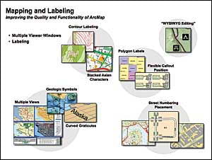
At ArcGIS 9.3, there will be great improvements in mapping and labeling, including more polygon labeling choices, labeling along graticules and curved lines, and better contour labeling with stacked contours.
There will also be what you see is what you get (WYSIWYG) graphic editing that allows GIS professionals to interactively move symbolized features while viewing them on the map. There are also new tools for better street number placement at the end of line segments, support for stacked vertical Asian characters, and new symbol options.
Finally, ArcGIS 9.3 will support multiviewer windows, permitting users to set up multiple symbology displays for the same geographic features.
Supporting Better 3D Analysis and Visualization
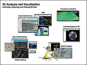
ArcGIS Desktop 9.3 will include many visualization enhancements, including support for textured collaborative design activity (COLLADA) buildings, better labeling on 3D surfaces, new tools for 3D spatial analysis, faster import of Web services, and “tracking” of objects in 3D. This environment will allow users to visualize moving objects, such as airplanes, in real time.
Editing Cadastral Fabrics with ArcGIS Survey Analyst
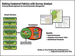
At ArcGIS 9.2 (Service Pack 3), Esri released support for a completely new version of ArcGIS Survey Analyst. This extension is helping GIS professionals manage cadastral fabrics (land parcels integrated with survey data). Specifically, ArcGIS Survey Analyst provides a new workflow that integrates survey measurements into the cadastral fabric. This extension supports a new data model in the geodatabase called a cadastral fabric.
We believe this technology and related workflow will bring the survey and GIS communities closer together by providing a common database for managing survey-based parcel data. A secondary benefit is that it allows users to incrementally improve all the other GIS layers by linking spatial adjustment to the basic cadastral fabric layer. This means that as new/improved survey adjustments are made and integrated, it will be possible to automatically adjust (improve) other layers in a geodatabase.
ArcGIS Server
ArcGIS Server is a complete Web GIS server providing mapping, 3D visualization, spatial analysis, geoprocessing, and data management services. It has out-of-the-box applications and provides a framework for building advanced geospatial applications.
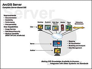
ArcGIS Server 9.3 improves scalability, performance, and documentation. It includes both new and considerably enhanced Open Geospatial Consortium, Inc. (OGC), interoperability capabilities and a new image service. The image service will allow full, rich imagery to be served not simply as a map but also as a full stack of multispectral data in a very fast Web service environment. ArcGIS Server at 9.3 will also include the ability to have role-based security for enhanced protection on the Web.
At 9.3, ArcGIS Server will support a full REST API, giving users the ability to easily create mashups between their GIS servers and virtually any other service on the Web using Java scripting.
ArcGIS Server is engineered to work closely with ArcGIS Desktop. The workflow involves content and services being authored on the desktop, dropped onto a server, and made available to the enterprise. Using Web services standards, users can integrate distributed services as well as serve up applications within and beyond an organization. (See “Enterprise GIS Is Here.”)
ArcGIS Server Manages Geodatabases
Geodatabases are the heart of an ArcGIS system. They manage a complete information model of geographic data in heterogeneous and scalable storage environments. These include DBMSs, such as IBM DB2, Oracle, and Microsoft SQL Server, as well as scaling down to files.
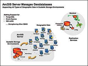
At 9.3, ArcGIS Server Enterprise will add support to the open source DBMS PostgreSQL (both ST_Geometry and PostGIS spatial types); Oracle Express; and for mainframe users, DB2 running on IBM z/os series platforms.
ArcGIS Server manages replicated copies of geodatabases in distributed environments. For example, the State of Maryland Highway Administration is implementing a system where the road data is maintained in a centralized database. However, there will also be copies of this data in each county. When a county updates its local database, perhaps adding or changing a road, an update is sent to the state via Web services. Conversely, when the state makes changes, an update is sent to the county, so they’re collaboratively maintaining the data. At ArcGIS 9.2, this is done via a two-way replication environment. At ArcGIS 9.3, users will be able to perform one-way replication to a file geodatabase (e.g., sending an update out to a field unit or field office).
ArcGIS Server Manages Imagery
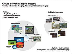
Today there is rapid growth in the volume and availability of high-quality digital imagery. ArcGIS Server is designed to take advantage of the explosion in availability of imagery by providing a complete system for managing and exploiting geospatial images. ArcGIS Server can manage very large images, rapidly analyze and process these images, and serve this imagery in both 2D and 3D visualization environments.
At 9.3, Esri will introduce a new image service to ArcGIS Server that allows GIS professionals to serve multi- (and hyper-) spectral, multiresolution stacks of imagery on the Web. Traditional image processing workstation systems (e.g., ITT Visual Information Solutions’ ENVI) will be able to consume these services directly.
For those wanting to mosaic and process their imagery on the fly, at 9.3, Esri’s ArcGIS Image Server will become a standard extension of ArcGIS Server. ArcGIS Image Server users will be able to take raw imagery collected by airborne or spaceborne sensors and immediately make it available as a Web service. ArcGIS Image Server performs image processing on the server at the time of request, bypassing the costly image processing work that has traditionally been performed in the workstation environment. This capability dramatically shortens the time between image capture and availability to end users and is essential for modern GIS systems in the enterprise environment.
Web Mapping Gets Better
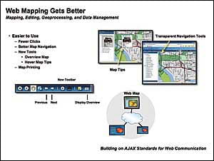
Web mapping with ArcGIS Server gets easier to use at 9.3. A variety of functionality and navigation enhancements will be introduced to leverage the new emerging AJAX standards for Web communication and make the user experience simple.
ArcGIS Mobile—A New Mapping Application
ArcGIS Server 9.3 improves the current ArcGIS Mobile Software Developer Kit available at 9.2 with the release of the ArcGIS Mobile Editor application. Using the support of GPS, GIS professionals will be able to edit geographic datasets and maps while in the field. The ArcGIS Mobile Editor application will operate in both connected and disconnected environments.
Professional applications for ArcGIS Mobile Editor are endless—utilities, forestry, environmental monitoring, field engineering, etc. With the integration of ArcGIS Server, users will be able to view each others’ locations and collaborate effectively. First responders, for example, will immediately be able to share their field data dynamically across the organization. Specifically, the data captured using this application can be instantly synchronized with the server, so everybody can see via real-time technology where users are located and what data is currently being measured in the field.
ArcGIS Explorer—A Simple Geobrowser
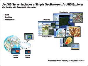
ArcGIS Server includes ArcGIS Explorer, a free, downloadable application that is similar to consumer viewing applications, such as Google Earth. While ArcGIS Explorer provides simple-to-use 3D visualization and continuous viewing capabilities, its big advantage is that it is fully integrated with ArcGIS Server and can “task” the server to perform sophisticated analysis, then return results to this simple-to-use tool.
Using ArcGIS Explorer, users can directly access and interact with dynamic data (i.e., data that is maintained and updated) in a geodatabase. They can also run sophisticated models that have been set up on a server, or even several servers, at the same time.
Included in ArcGIS Explorer is a collection of free services available via ArcGIS Online that can be used with local data, as well as ArcGIS Server, ArcIMS, and other standard Web services.
Esri’s goal in developing ArcGIS Explorer is to provide our users with a free client that delivers the same user experience and capabilities of consumer applications but at the same time integrates with a complete GIS, including the powerful analytic capabilities.
ArcGIS Server Is Open and Interoperable
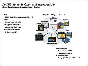
Esri continues to focus efforts on integrating standards into the ArcGIS platform—particularly the server. These include Web standards, OGC standards, and enterprise standards—helping our users interoperate with other IT and GIS systems. We also pay considerable attention to other industry content standards that are unique to particular applications, such as CAD files, imagery, and PDFs.
We will continue to evolve and improve our support for standards to ensure that within the GIS and IT communities our products are open and interoperable. Within the proprietary world, we are working to make our tools increasingly interoperable with the technology from Google, Microsoft, Autodesk, and Adobe.
ArcGIS Includes Support for AutoCAD
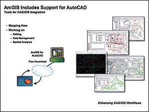
As part of our efforts to improve interoperability, Esri developed a free, downloadable set of tools called ArcGIS for AutoCAD that provides access to ArcGIS Server capabilities from the AutoCAD environment. This application is now focused on mapping, but in the future it will support editing, spatial analysis, and data management. Our long-term objective is to allow AutoCAD users to leverage all the features available via ArcGIS Server. (See “New ArcGIS for AutoCAD 2008“.)
ArcGIS Server Supports Mashups
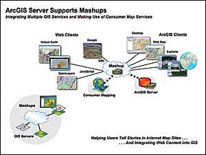
At ArcGIS Server 9.3, through a REST API and Java Scripting, GIS professionals will be able to easily create mashups. A mashup is created by combining two or more Web services in a Web application. In a mapping/visualization environment, this involves overlaying multiple map services to create an integrated view. Although this has been possible to do in ArcGIS Server 9.2 using the SOAP API, at 9.3 we will provide a full REST API that supports the very lightweight JavaScript development environment.
Beyond mapping, users will be able to mashup their services with virtually any Web service by building simple JavaScript applications that combine these services. This will help users easily build new ways to collaborate by integrating and combining many types of Web content.
ArcGIS Server Can Be Federated
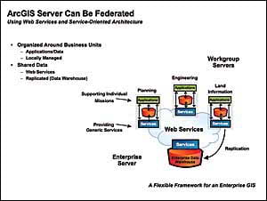
ArcGIS Server can be implemented in a federated architecture, allowing different departments in an organization to collaborate in the development of a distributed enterprise system. For example, a city’s planning, engineering, and land information departments may each have their own server with geoservices that support each other’s operations. As the diagram below suggests, this architecture allows each department to run its own operation supporting department-specific applications and at the same time serve generic services onto the network for colleagues in other departments. For example, one department may create and serve a basemap used by other departments.
The diagram also illustrates how data from departmental systems can be replicated in an enterprise warehouse for backup and recovery requirements, as well as to support enterprise-wide applications.
This architecture provides a flexible formula that can be implemented at many scales and among many types of organizations (e.g., city-state, local governments-utilities, state-national).
ArcGIS Online
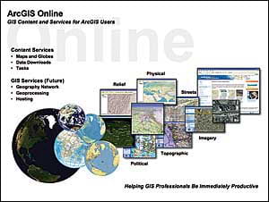
ArcGIS Online is an important component of the ArcGIS family that offers new opportunities and resources that empower GIS professionals. Fundamentally, it provides basemap services (maps and imagery) for ArcGIS users. ArcGIS Online is free for desktop clients and made available at a low cost for ArcGIS Server users.
The three common ways to use ArcGIS Online as a basemap are on the desktop, for Web browser applications, and in ArcGIS Explorer. ArcGIS Online can also be consumed as part of an ArcGIS Server Web site or application.
Conclusion
Our world has many problems and needs a new approach and a new framework to chart a better future. We need to better understand and communicate these problems and apply methods that change our course.
Esri believes the geographic approach plays a critical role in making these changes. We are developing our software so it is responsive and gives our users the tools they need to help create a more sustainable world.
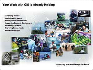
The work of GIS professionals is already helping. They are building the infrastructure of the geographic approach, advancing science, designing with nature in mind, making communities more livable and efficient, improving human health, and mitigating social conflicts. GIS professionals are improving how we manage our world.
In these first four decades of GIS technology, we are making a difference, changing the way we see and do things. But more than technology is required. Clearly, the vision, dedication, and especially hard work of GIS professionals are what will be important in the future.
We appreciate our relationship with our users. They make it possible for us to do our work in service to them.