


|
|
||
|
|
|
|
|
|
GIS Powers New Brunswick DOT into the Fast Lane
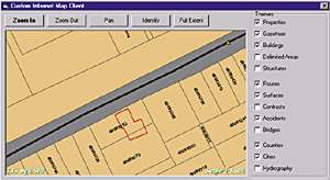
In accordance with its pragmatic approach, the department completed an extensive eight-month evaluation process before selecting Esri to provide a suite of products to meet its GIS needs. The initial focus of the implementation is on the delivery of the department's existing data to staff utilizing Esri's Web-based GIS software. According to Andy Legere, manager of Engineering Systems, the department developed a very detailed technical request for proposal (RFP) based on a comprehensive user needs analysis. The RFP and subsequent selection process was very thorough and is now being considered by other government agencies as a guide. Comments Legere, "It was a very long, detailed process, but it gave us a comfort level that we made the right choice. We believe that we have purchased the best product available that will meet our current and developing GIS requirements." Plans at NB DOT call for a multiphase implementation. Phase One is a short-term plan designed to provide immediate access to existing data. "We have very good data here in NB," says Legere. "We believe that it is some of the best map data in North America. We have a provincial coverage at 1:10,000. This covers all of our enhanced topographical mapping as well as our property mapping for the entire province. One of the things that we want to do with the GIS is to give people access to much of the data that already exists. We are currently identifying those databases that are right there and ready to use. With GIS, we can provide a tool that allows easy access to that data on a very broad basis. We have also identified a number of high priority data sets that we want to provide immediate access to as well." Those data sets include contract limits, the physical location of current highway projects in which contracts have been awarded, bridge data, and right-of-way plans. A key element of NB DOT's Phase One implementation is the development of Web-based applications that will allow easy access to the existing databases through the use of MapObjects.
Legere describes the existing system: "We have road life diagrams that presently give us a graphical snapshot of some of our data. These diagrams contain various information about a road, such as the number and severity of accidents, the horizontal and vertical alignment, the ride index, the pavement composition, and so forth, all in one big diagram. Right now it's a manual process to go and look at those things and do an analysis of them. There are a number of applications and supporting databases in place, but they are almost like silos; they do a certain function but don't integrate well with other systems. (A silo is an independent, stand-alone system.) You might have a system that calculates your ride index, but it's not possible to analyze that against some other data because of a lack of compatibility between the two systems. That's one of the key things that we are looking at GIS to do for us; to really help facilitate the integration of data. We have a lot of independent systems out there that do specific functions, but we want the opportunity to compare and combine the data from these stand-alone units. "We are really looking at GIS to give us that data integration capability. If we want to analyze the speed of the road versus the traffic volume versus the horizontal alignment of the road, we can do that type of data integration. Right now, it is a very manual and very difficult process to do that kind of analysis. Strategic for our GIS implementation is the ability to integrate a lot of that corporate data. This is very difficult for us to do today." To support this initiative, NB DOT has developed a set of location data standards that will be enforced across all databases that will be accessed using GIS tools. This data will be made available in an online Oracle data repository. "We want to serve as much of this data over the Web as we can. This is going to be our main initiative," continues Legere. "We will be developing Web-based applications to provide access to linearly referenced data by means of dynamic segmentation in Phase Two of our implementation program. For example, you may want an application that examines traffic volumes over a segment of road to show all the traffic volumes that have a certain ADT factor over a specified number or examine sections of highway that have a good rideability compared with those that have a poor rideability. Pavement management is another obvious dynamic segmentation-based application we will be developing early on. We have a lot of pavement management data, and GIS is a very valuable tool for doing that kind of analytical work." Legere believes that GIS will have a substantial impact on the NB DOT. One effect is increasing the ease of access to corporate data.
"There is a huge potential for the use of GIS in the transportation industry," he concludes. "Not only is the bulk of the data spatially referenced, but GIS has the capability to integrate the various file types found within the industry. "I think that GIS is going to revolutionize the access to data in the transportation industry by allowing the integration of various data types and providing easy access to that data by a large number of people very easily and at a very low cost via the Web. The Web will also minimize the amount of training required by staff to access that data and help them use it as quickly as possible." For more information, contact Andy Legere (e-mail: andyl@gov.nb.ca). |
 "To provide and maintain a safe and efficient transportation system in all matters within provincial jurisdiction and to monitor and advise on all matters of federal jurisdiction" is the well-considered mission statement of New Brunswick Canada's Department of Transportation (NB DOT).
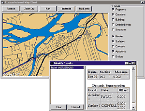 The department's entire complement of Esri GIS software includes ArcInfo as its main engine, with ArcView GIS, ArcSDE, and MapObjects software driving its Web-based applications. Much of the department's data is linearly referenced, making ArcInfo software's dynamic segmentation capabilities crucial to analyzing the data.
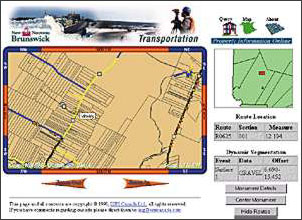 "We have a huge volume of data out there, and unfortunately it is not very accessible," he says. "We see GIS allowing access to this data by a lot more people, particularly those in our regional offices. We find that often they are quite isolated. Now, with just a Web browser, we can make that information just as readily available to the regions as it is to the head office. We see that as having a very positive impact on the department."