


|
|
||
|
|
|
|
|
|
Taking GIS to the FieldIntroducing ArcPad
Windows CE-based PC companions are becoming more affordable and widely used, providing for the first time a practical platform for field GIS. The addition of a field GIS solution to Esri's comprehensive family of GIS software programs, which includes ArcInfo and ArcView GIS, gives users a new way to leverage their geographic databases in the field. Mobile GIS for Field Data Entry
ArcPad software's mobile maps can show current position, speed, and distance to destination. ArcPad can be carried in hand or used in a vehicle and will show your current position on the map with an optional GPS. Your position coordinates are readily available instantly at the touch of your pen on the photo or map. When using GPS, the Position window constantly updates your coordinates using data from the U.S. Department of Defense's constellation of 24 GPS satellites in orbit 22,000 km above the earth. Many Potential ApplicationsArcPad software's potential uses are immense, from geological surveying, asset collection, and power pole mapping to maintenance engineering and map updating.
ArcPad enables specialized mapping and data collection in an almost limitless range of industries and applications. ArcPad is tightly integrated with ArcView GIS 3.2. Included with ArcPad is ArcPad Tools for ArcView, an extension that allows ArcView GIS users to clip shapefile themes and write ArcPad project and symbology files. ArcView Dialog Designer forms can also be exported to ArcPad, making field data collection a snap. The next release of ArcPad, scheduled for availability in summer 2000, will feature integration with ArcInfo 8. ArcPad SDK, scheduled for availability later in summer 2000, will give developers the ability to build custom field mapping solutions using powerful ArcPad components. For more information, call Esri at 1-800-447-9778 or visit www.esri.com/arcpad. ArcPad can be licensed online at www.esri.com/gisstore, or call your Esri regional office or Esri at 1-800-447-9778, or contact your local reseller. Outside the United States, please contact your local Esri distributor. |
 Esri is pleased to announce the completion and release of ArcPad, a field GIS that operates under Microsoft Windows CE. A low-cost solution for data capture projects, ArcPad displays standard vector and raster data stored in industry formats including shapefiles, JPEG, bit map, and MrSID compressed images. ArcPad takes your GIS to the field and gives you the ability to display and query many layers. Simply use Windows Explorer and Microsoft ActiveSync on the desktop PC and transfer GIS databases to the Windows CE palm-size computer; use, update, and modify the data in the field; then upload the changes back into the master database back at the office.
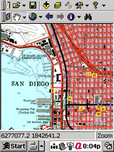 ArcPad is a handheld GIS that enhances portable touch-screen Windows CE computers with vector map and raster image display, user-defined form-filling capability, and real-time positioning using an optional global positioning system (GPS) receiver. ArcPad allows you to create, delete, and move features on the map. You can also mark existing features and enter information about them. These features can be included in the project database and uploaded into your desktop GIS.
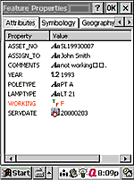 ArcPad gives users a new way to look at and use their data—live in the field. Comparing the GIS database directly to geographic features in the real world adds a deeper sense of reality to the database. It also opens many new avenues for mobile data collection. ArcPad technology can be used for a variety of applications including