
g.net—A New GIS Architecture for Geographic Information Services
By Jack DangermondGeographic information systems are evolving to support a new, network-based architecture. This architecture is multiparticipant, collaborative, and will allow  organizations to openly share and directly use GIS information from many distributed sources at the same time. We call this the Geography Network architecture, or g.net, because it was first implemented for the Geography Network. This architecture is based on providing and consuming geographic information services through open, Internet protocols. The architecture works with any scale of implementation and in any size organization. It promises to leverage the work of GIS professionals and radically enlarge the use of GIS in the world. It will also provide a whole new way for GIS organizations to share their geographic knowledge and work together.
The Need
The Global Environment Outlook 2000 report by the United Nations Environment Programme (UNEP) makes it clear that the world's landscape is changing at an ever increasing rate. We are experiencing increased use of natural resources, reductions in  biodiversity, and seeing the early effects of global climate change. Human economies are going through fundamental restructuring (e.g., globalization) and at the same time, we are seeing significant breakthroughs in some areas of information technology and science.
Also, our society is evolving toward greater specialization. Our disciplines are being divided into smaller and smaller areas of study, and our information systems reflect this. This specialization focuses people to see the world in pieces rather than as a whole and, with the growing barrage of data, professionals are finding it increasingly difficult to work outside their own fields or enterprises. The result is that holistic thinking and problem solving are less understood and less practiced.
We, however, know that more integrated approaches are important. E.O. Wilson, in his recent book Conciliance—The Unity of Knowledge stated, "a balanced  perspective cannot be acquired by studying disciplines in pieces, but through the pursuit of the conciliance among them." Our future will depend on bringing our knowledge together in a form that can be easily understood and used.
GIS has long been recognized as a technology that can help cross borders and see the whole by integrating information into a common spatial and visual language. GIS connects people and their interests. It facilitates cooperative and team approaches, and with the integration of GIS and the Internet there will be a whole new framework for organizations and society to work together and make decisions.
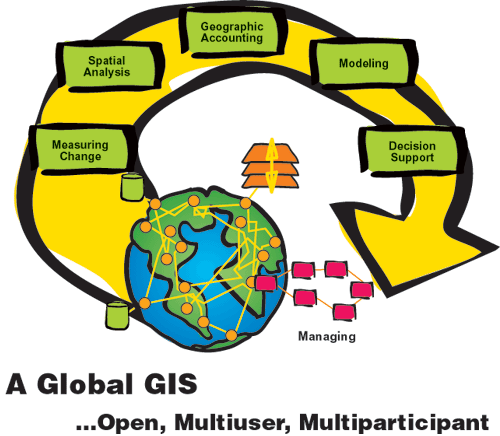
The Societal GIS Vision
Initially, GIS was seen as important because it offered a system and digital methods for integrating, analyzing, and visualizing geographic information. GIS later emerged as a powerful technology for coordinating and integrating the work of an organization around a common and shared geographic database. GIS is now evolving into an architecture  allowing communities of organizations to connect and share their geographic information and applications as network-based services to one another.
As these geographic information systems become interconnected, they will evolve into a global network that can be used in many ways by both GIS professionals and by society in general. This is similar to the way that global financial systems have been networked resulting in better organization and understanding of our global economy. Global GIS networks, however, will be different in content and different in purpose. They will focus on creating a framework for integration of the physical, social, biological, and environmental aspects of life.
Enabling Technologies
There are a number of enabling information technologies (computers, software, communication networks, and especially the Internet) that are co-evolving and will  support the growth and widespread use of GIS in society. The computer revolution is moving toward providing pervasive computing—computing that includes the use of devices that are wireless, interoperable, personal, and locationally aware. The GIS architecture for the future will be distributed, networked, interoperable, and built using Internet standards and technology. This architecture will have four initial implications.
First, it will provide GIS professionals with a new and open environment for sharing and interconnecting their information. The Geography Network is a good example of this architecture at the global scale. However, this same architecture is practical at many scales both within and among organizations.
Second, the geographic information server architecture allows organizations to "publish" or serve GIS applications to much larger communities. An example of  this is the National Geographic Society's MapMachine. The MapMachine provides dynamic thematic maps, showing natural and human phenomena at a global scale. This site is accessible to anyone with an Internet connection and supports the generation of more than 500,000 customized, GIS-based maps every day.
Third, emerging distributed data management technology and mobile/wireless computers will allow the full functionality of GIS (e.g., editing, spatial analysis, and visualization) to be used in the field.
Finally, this architecture together with mobile computing, GPS, and telecommunications will create a whole new "consumer focused" application of GIS known as "location-based services." These services leverage GIS data and geoprocessing functions for applications such as tracking of people and objects, routing, mapping, locating services, telematics, and e-yellow pages.
The Geography Network and g.net
The Geography Network is the result of a vision for sharing and directly using distributed geographic information services (www.geographynetwork.com). It is an open, collaborative, and multiparticipant system that lets users publish, share, and use each 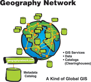 other's services. Technologically, it is based on the open standards and "loosely coupled" architecture of the Internet. Key distributed subsystems include a metadata catalog service, distributed GIS data and application services, and GIS clients that directly use these services.
The g.net architecture supports distributed data management, metadata searching, and dynamic data integration into desktop, browser, and mobile applications. This architecture easily supports departments and divisions of an organization using each other's information via the loosely coupled protocol of XML.
The g.net architecture is already being implemented by several major GIS communities (e.g., the State of Texas and UNEP). They each have taken the concept and built their own versions of the Geography Network using standard product components. These systems are stand-alone, but they can also be integrated into the larger Geography Network community for broader information sharing.
These initial efforts demonstrate that organizations and communities with distributed GIS data, such as states and local governments or national organizations, can practically implement their own server-based GIS networks. These networks will provide many synergistic benefits and ultimately create the foundation for what people commonly refer to as a spatial data infrastructure.
Is This Open and Multiparticipant GIS Vision Practical?
I believe so. It is my experience with the GIS community and also with the Internet that organizations want to share their knowledge and will evolve to an architecture that supports this vision. The technology to support this is now available, affordable, and scalable. However, widespread and effective adoption will require that organizations and society, in general, be willing to take the ongoing responsibility for supporting the creation and dissemination of their geographic information. Open and multiparticipant GIS requires policies and procedures that support open information sharing as well as an understanding of the huge value and benefit of participating in geographic information service networks with other organizations.
Perhaps the best evidence that this vision will work is the thousands of existing organizations (at many levels of government) that already support Web-based models for geographic information services and data dissemination. These sites demonstrate the principles of open access and also illustrate the value of cooperation and sharing.
Software Vision
At Esri, we have been developing and testing the architecture and software subsystems  to support the g.net vision. This has involved both a careful assessment of our users' needs and understanding of rapidly evolving technologies. As we proceed with this direction, we will be sharing our understanding with our users and asking for feedback.
Some of the key technical concepts of this architecture are described here:
- Open and modular architecture that allows subsystems to be independently created and deployed in a distributed and "loosely coupled" Internet environment using standard XML protocol
- Strong, open data management supporting very large databases with many users
- GIS application server architecture supporting a full range of geographic services
- Array of network (Internet)-aware GIS client solutions including desktops, browsers, mobile devices, and embedded solutions
- Strong geoprocessing logic for queries, spatial analysis, cartography, and three-dimensional visualization tools
- Standards-based metadata catalog services
- Software that is open, interoperable, and technologically compliant with the whole range of IT standards
- Full support for open spatial data standards (OGC, ISO, CEN, FGDC�) See also "Committing to Open Standards."
 Technologically, the Geography Network and the g.net architecture are only beginning. New developments in peer-to-peer, collaborative, and mobile computing, as well as distributed data management, promise to provide very exciting opportunities for all GIS users.
Conclusion
The g.net architecture and its associated subcomponents will help GIS organizations and professionals provide geographic information services to whole new communities. The g.net architecture will also mean that GIS organizations will be able to cooperate more effectively by sharing and leveraging their knowledge. The result  of all of this will be a kind of social network delivering GIS capabilities to everyone. This will mean greater spatial literacy, awareness, and accountability. I believe strongly that this initiative is important. Esri will continue to develop technology to support this vision.
This article is based on several presentations given by Jack Dangermond at a number of recent GIS events.