
Geography Network Supports Open Standards
Esri is committed to providing software that enables users to easily create, provide, and share geographic data with other users. Now Esri has brought the sharing of  geographic data to a new level with the Geography Network (www.geographynetwork.com), an Internet portal that allows data providers from public, private, and nonprofit organizations to publish geographic data, maps, and services on the Internet. The Geography Network allows all data to be published in an open format and in definable scales that result in the data being easy to use.
Esri is not alone in its quest for providing geographic data in an easy-to-use format accessible by everyone. Since a Federal Executive Order in 1994 requesting government 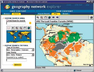 entities, private enterprise, and academia to work together to define standards for sharing geographic data, Esri has participated in a number of organizations and standards committees. Today, Esri is an active participant in the OpenGIS Consortium (OGC), a body of government, academic, and technology organizations that meets to create interface specifications among different vendors' GIS products, enabling them to share and disseminate geographic data. The goal is to develop specifications that software developers can use to create products that work together regardless of brands, operating systems, or networking software.
Above left: The Geography Network Explorer allows users to easily define their area and criteria of interest.
Esri has implemented several specifications that have been agreed on by the OGC and has made them available to the public. One of the specifications Esri's software conforms to is the OGC's Simple Features Specifications, which allow different software vendor packages to communicate basic geographic data at a common level for access and analysis. Esri has also implemented the Web Mapping Server (WMS) Specification in its ArcIMS software and on the Geography Network.
The WMS services are a methodology for publishing geographic data in a standardized format over the Internet, allowing them to be easily
 published and accessed. Geography Network map services can be published using either the ArcXML protocol, another protocol enabling the publishing of geographic data on the Web based on the industry-standard Extensible Markup Language (XML) created by Esri and employed by Esri's ArcIMS software, or the WMS protocol. WMS map services can be accessed using the free Geography Network Explorer or any WMS application.
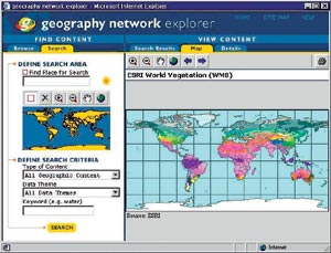
Above right: Esri also implemented the Web Mapping Server (WMS) Specification in its ArcIMS software and on the Geography Network.
The Geography Network complements and supports the Federal Geographic Data Committee's efforts to create a National Spatial Data Infrastructure (NSDI). It also supports the international community's efforts to create a Global Spatial Data Infrastructure (GSDI) and a Digital Earth. Each of these initiatives encompasses policies, standards, and procedures for organizations to cooperatively produce and share geographic data in an open environment. This adherence to industry-standard formats and technology makes it easier than ever to publish geographic data on the Internet.
The Geography Network supports the federal government's strategies for the dissemination of geographic data by adhering to its four goals.
The first goal is to increase the understanding of the vision, concepts, and benefits of the NSDI through outreach and education. The Geography Network supports this vision by promoting data sharing through a virtual marketplace environment for geographic data, maps, and services.
Second, the Geography Network supports developing common solutions for discovery, access, and use of geographic data in response to the needs of diverse communities. The 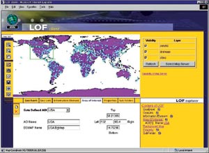 Geography Network infrastructure was built to support a wide range of GIS services and solutions by allowing publishers and developers the ability to customize the user's interface. Customization of the interface allows for clearer communication and maximum usability of the data that is appropriate for different communities. Geographic data can
be presented in many different ways depending on its intended use. For example, elementary school students may present and use the data content in a very different way than members of the Associated Press or a government agency.
Geography Network infrastructure was built to support a wide range of GIS services and solutions by allowing publishers and developers the ability to customize the user's interface. Customization of the interface allows for clearer communication and maximum usability of the data that is appropriate for different communities. Geographic data can
be presented in many different ways depending on its intended use. For example, elementary school students may present and use the data content in a very different way than members of the Associated Press or a government agency.
Above left: The Location Organizer Folder (LOF) client is an Esri tool that was developed as part of Esri's commitment to open standards technology.
Using community-based approaches to develop and maintain common collections of geospatial data for sound decision making is the third tenet of the spatial data standard. The Geography Network supports locally distributed and maintained databases such as clearinghouses. Organizations can retain control over their own data while making it available through the Geography Network, enabling access to this data by many. National and international FGDC registered clearinghouse sites are registered on the Geography Network to provide GIS users with the most geographic data possible.
Last, the Geography Network assists in building relationships among the organizations that are supporting the NSDI. The Geography Network provides the infrastructure to build and support the sharing of data across different industries, organizations, and nations. The virtual marketplace of the Geography Network lends itself to building new and innovative relationships that encourage the involvement of the user in developing new geoservices and solutions.
Esri continues to be active in creating an open environment through its software products and its participation in the development of the Geography Network.
Read Esri's newest white paper explaining these concepts in more detail, entitled The Geography Network and the NSDI, available on GeographyNetwork.com. For more information, visit the Geography Network at www.geographynetwork.com.