
Executive Information Management System Wins Excellence Award
Pennsylvania Turnpike Maintains Roadway and Driver Safety with GIS
The Pennsylvania Turnpike, America's first superhighway, officially opened October 1, 1940, carrying traffic  over a 160-mile section of the Commonwealth of Pennsylvania. During its first year of operation, 2.4 million vehicles traveled the Pennsylvania Turnpike. This highway forever changed the way Americans traveled—long distances at high speeds, along an entire roadway without a stop sign, traffic signal, or pedestrian crosswalk. The Pennsylvania Turnpike became the forerunner of the country's Interstate Highway Network that today consists of approximately 43,000 miles including 2,300 miles as toll roads.
Above right: During the 1999-2000 fiscal year, 160 million vehicles traveled the Pennsylvania turnpike.
Four major extension projects during the 1950s expanded the turnpike from the Ohio state line to the New Jersey border and from Norristown to Scranton. With several new expansion projects throughout Pennsylvania, including the newly opened six-mile-long Mason-Dixon link on Pennsylvania's side of the Mon-Fayette Expressway in western Pennsylvania, the turnpike provides 512 miles of limited access toll highway. During the 1999-2000 fiscal year,160 million vehicles traveled the highway.
The Executive Information Management System
The Pennsylvania Turnpike Commission (PTC) employs approximately 2,300 people and manages 20 maintenance facilities, 55 fare collection facilities, 22 service plazas, and two traveler information centers.
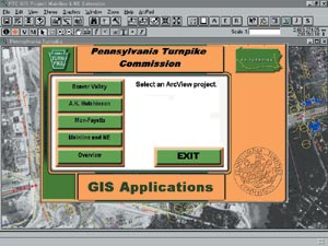 As part of their commitment to maintaining the roadway and the safety of drivers, the PTC has implemented an Executive Information Management System (EIS) that uses GIS technology.
Through the leadership of Jeffrey Messaric, a team of IT professionals at the PTC worked with W.E.C. Engineers, Inc., an Esri Business Partner, to launch the project. W.E.C. was a natural choice for the project since the firm specializes in both transportation engineering and GIS. Stephen Husic, manager of technologies for the PTC, was responsible for coordinating the various components of the Executive Information Management System.
The EIS vision was to geographically enable the many data collection systems that existed at the PTC and provide a single means of access to enterprise data.
Designing the EIS
The EIS has five essential components.
- Digital spatial data
- Customized ArcInfo and ArcView GIS—the "heart" of the EIS
- Attribute data
- Database and spreadsheet applications
- A Visual Basic interface and a suite of custom applications
Custom features were added to the EIS to enhance the functionality of ArcView GIS and to add a geographic component to database applications using ArcView GIS software's database connection extension. For example, pulldown menus were created to facilitate zooming to any spatial feature in a View document. Other custom features include the capability to label mileposts automatically, to specify the database fields that are visible when a feature table is opened, and to identify all available database information for any point on a map that is selected with a mouse click.
Data Conversion
The data to be converted and integrated within the EIS was in multiple file formats, diverse databases, and created 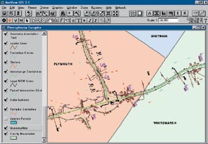 in different development environments. The mapping data in AutoCAD was converted to ArcInfo coverages and ArcView GIS shapefiles. Database information was linked to the mapped features through a unique feature ID or through a known milepost location. CAD drawings and aerial photographs were georeferenced using ArcInfo software's ARC GRID extension so that the features now represent "close-to-real-world" locations of turnpike features. Programmers used ARC Macro Language (AML) code to automate this georeferencing process.
Above right: The integration of multiple CAD files into statewide coverages was the first task in developing the Executive Information Management System (EIS).
Using ArcInfo software's ARC NETWORK extension, the turnpike centerline was also developed as a dynamically segmented route to allow users to locate features by entering a milepost number. The EIS based on ArcView GIS enables users to locate any feature or incident along the turnpike by simply entering a milepost location or by pointing and clicking. Because all bridges, communication towers, incidents, traffic reporting, capital projects, etc., are identified by their milepost location or range, this information can be used to plan, track, and manage turnpike operations. The value of easy access to this data was immediately evident through the ability to locate and manage assets such as bridges, survey monuments, and roadway signs.
Project Benefits
Husic notes, "Our number one concern is the safety of our customers. The PTC Information Technology Department's job is to help other departments manage the information required to maintain the safety of the roadway. The PTC needed to integrate 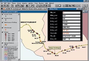 mapping, imagery, and various databases to allow a single access point for enterprise data and to foster the sharing of this data throughout the organization. GIS, the heart of the EIS, was the data integration tool that allowed us to do that."
Left: With EIS, managers can display bridges by their milepost location and the year each structure was built.
Another EIS goal was to provide a decision support application that required minimal training. The EIS transforms existing data into meaningful information that provides operational and decision support capabilities to PTC executive staff. "The EIS applications allow PTC employees, especially managers and executives, to locate features and projects on a map—which changes dynamically when databases are updated or modified," says Husic. "This gives us current, efficient access to the most recent information within an overall context of other projects that are occurring within a given length of the turnpike."
The EIS/GIS data, originally developed to assist the engineering department, has produced significant cost savings in implementing a new computer-aided dispatch system (CADS). Because dispatchers face daily challenges to locate emergencies and deploy appropriate vehicles and services, an electronic mapping capability was critical to the new system. Without the availability of the GIS data, the PTC would have spent more than $100,000 to develop the spatial data needed to provide a high level of emergency services.
Additional benefits associated with the EIS applications include
- The capability to simultaneously access and analyze multiple data sets from a common front end—a customized ArcView GIS interface
- The ability to improve traffic flow through better planning of projects that are in close proximity or through improved traffic management of high traffic areas
- Improved communication with the public, with government officials, and among PTC departments about how projects may affect PTC operations and customers
- The capability to manage existing assets more efficiently
- Enhanced decision support tools through improved visualization and analysis capabilities
Award and Conclusions
The PTC submitted the EIS project to the International Bridge, Tunnel and Turnpike Association and was honored with the 2000 Toll Innovation and Excellence Award. The award highlights the PTC's excellence in using GIS technology to assist with roadway maintenance and driver safety. GIS is the key component of the EIS that allows managers to view roadway and infrastructure databases through an easy-to-use mapping interface.
"With the help of our executive management staff," explains Husic, "we have created a plan and developed priorities for the EIS. We are currently executing this plan, building on the EIS foundation. For example, as part of the plan we are currently integrating the Capital Planning-Project Reporting System and will eventually geographically enable the Records Management System."
For more information, contact Stephen M. Husic, manager of technologies, Pennsylvania Turnpike Commission (e-mail: shusic@paturnpike.com), or James E. Vitale, Ph.D., executive vice president, W.E.C. Engineers, Inc. (e-mail: jev@wecengineers.com).