


|
|
||
|
|
|
|
|
|
Preparations for the Year 2000 CensusIowa's Role for ArcView GIS in Redistricting
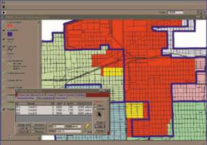
The LSB is participating in the Census 2000 Redistricting Data Program. Phase 1 of the program is called the Block Boundary Suggestion Project (BBSP). For Phase 1, the LSB acquired software developed by Election Data Services Inc., a Washington, D.C., based consulting firm and an Esri Business Partner, for ArcView GIS. The software enables the LSB to participate electronically in BBSP. Election Data Services, the State's redistricting vendor in 1990, also provided the LSB with a database of current election precincts. Using the ArcView GIS-based BBSP software, the LSB prepared submissions to the Census Bureau indicating which geographic features in the TIGER/Line files form boundaries of election precincts and should be retained as block boundaries for the year 2000 census. The LSB also used the BBSP software to generate "sketch maps" to be annotated with corrections or missing features for submission to the Census Bureau as proposed TIGER/Line feature updates. Election Data Services is also providing the LSB with software for electronic participation in Phase 2 of the Redistricting Data Program--the Voting District Project (VTDP). The LSB will use the ArcView GIS-based VTDP software to prepare polygon files of current election precincts and legislative districts for submission to the Census Bureau. The submissions will enable the State of Iowa to receive population counts for those geographic units from the year 2000 census. The LSB will also be able to reuse the database of election precinct boundaries from the Census 2000 Redistricting Data Program in preparing a database for year 2000 redistricting. The precincts will be available with other units of the census geography to construct a new set of Redistricting Data Units (RDUs) in the year 2000 redistricting database. Removing the PoliticsUnder the Iowa code, after the decennial census the LSB must prepare congressional and legislative redistricting plans and present the plans in identical bills to both houses of the General Assembly.
In drafting a redistricting plan, the LSB must follow strict standards of the Iowa code. The standards (1) require districts to be of nearly equal population (maximum variances are prescribed), (2) discourage the division of counties and cities among districts (the number of divisions must be as small as possible), (3) require that districts be composed of contiguous territory, and (4) establish a preference for districts to be compact in form (the code prescribes a length-width compactness standard). The code prohibits the LSB from using other data that is typically part of a redistricting database: addresses of incumbent members, political affiliation of voters, results from prior elections, and demographic data other than head counts (except as required by federal laws and the Constitution). Redistricting in 1990The process works! Iowa was the first state with more than one congressional district to complete the 1990 round of redistricting. To draft the new congressional and legislative district plans, the LSB obtained software and a database from Election Data Services Inc. The software included special functions such as a compactness report applying the length-width compactness standard of the Iowa code. The database contained no political data. The database did, however, include a unique feature--RDUs. RDUs, which in Iowa are the basic building blocks for creating districts, consist mostly of election precincts keyed to total population counts from the census. Use of the larger RDUs, rather than census blocks typically used in other states, speeds map drawing and further removes politics from the process by facilitating the drawing of district. To evaluate redistricting plans drafted by the LSB, Election Data Services also provided identical databases to Republican and Democratic caucuses in the General Assembly. These databases, however, did include political data (e.g., election results, voters' party affiliation, incumbent members' addresses) to enable legislators to fully analyze the political ramifications of the new redistricting plans. For more information, contact Chris Thomas, Esri state and local government manager (tel.: 909-793-2853, ext. 1-1819; E-mail: cthomas@esri.com), or Kim Brace, Election Data Services (tel.: 202-789-2004). |
 With the new decade and census approaching, states are again preparing to redraw electoral districts to ensure equal representation of people in Congress and state legislatures. In the State of Iowa, a nonpartisan legislative agency--the Legislative Service Bureau (LSB)--is charged with redrawing congressional and legislative districts.
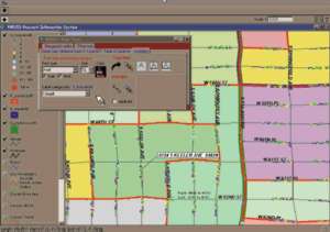 The Iowa code requires the LSB to prepare and deliver three congressional and legislative district plans to the General Assembly. The first plan must either be accepted without amendments or rejected. The same applies to a second plan. A third plan, if needed, can be amended. If a plan fails to become law prior to September 15, the Iowa Constitution provides that the Iowa Supreme Court shall cause the State to be redistricted.