


|
|
||
|
|
|
|
|
|
" . . . May Be the Most Dangerous City in the World"ArcView GIS Supports Crime Analysis in Karachi, PakistanBy Roman Pryjomko, United Nations Development Program Consultant and International Land Systems, Inc.
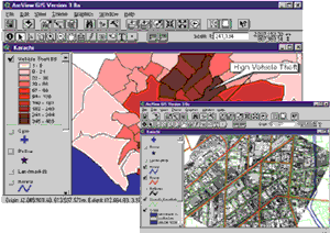
In fact, Fielding's Guide to the World's Most Dangerous Places mentions, "Karachi may be the most dangerous City in the world. Five to 10 people a day die from political violence. Murders, robberies, bombings, and kidnappings fill local newspapers every day." Through a project funded by the United Nations Development Program (UNDP) in Pakistan, ArcView GIS is central to an emerging spatial crime analysis system (SCAS) at the Citizen's Police Liaison Committee (CPLC) in Karachi. The committe was formed in the late 1980s and has a broad legal mandate. Some think that the CPLC may be the last barrier between order and anarchy in Karachi. The CPLC has recognized that crime in Karachi, as elsewhere, has a spatial component. By applying GIS, crime can be geolocated (usually by street address) to reveal significant trends, patterns, and relationships. This supports crime analysis, enforcement planning, and more effective resource allocation. The CPLC's SCAS project was designed in two distinct phases. The first involved the development of a customized digital street map of Karachi, followed by database development, systems integration, and applications implementation.
Pages of the guidebook were scanned and rasterized by MediaLink (Islamabad). The rasterized tiles (pages) were merged requiring considerable editing due to inconsistencies in line features. Once completed, the data was converted into separate DXF files and delivered to ECIL for topological work. Initial data conversion produced disparate and incomplete DXF files that required further processing to create a contiguous street database for Karachi. ECIL assembled the disparate DXF files into north and south sections, which were converted into ArcInfo format. The addition of a coordinate system and projection to the ArcInfo coverages required the collection of 17 ground control points. Field teams from ECIL were dispatched to predetermined locations to collect control points using differential GPS (+/- 1 to 5 m). Due to localized violence, the GPS teams were accompanied by armed personnel to ensure their safety, providing a reminder of the dangerous situation in the City. Subsequently, the two sections of the street database were map joined with final editing and adjustment. This seamless coverage was transformed and projected to create a geographic street database for SCAS. Ground truthing verified map features with details on the ground. The comprehensive annotation of the street database used information derived from the guidebook, official documents, and the local knowledge of CPLC and police officers. The point locations and names of more than 90 police stations throughout Karachi were added to the database. In theory, each police station possesses a defined police station jurisdiction (PSJ) boundary; however, the absolute definition of this frequently fuzzy boundary was problematic. Initially, PSJs were derived from a crude wall map at police headquarters; however, the exact delineation of boundaries caused considerable debate. This ambiguity supported reports that citizens were routinely sent from one police station to another to report a crime. A consultative process finally created a near-definitive PSJ data layer, which can be modified as required. The project team also defined administrative boundaries dividing Karachi into south, central, east, Malir, and west districts. In an extensive, unplanned city like Karachi, the street addressing system is confusing or nonexistent. This presents a major problem for law enforcement agencies that respond to incidents. Often, the only means of navigation is by local knowledge or landmarks known to the authorities and general populace. A standard operating procedure for the identification and classification of various types of landmarks within each PSJ was implemented. After two weeks, more than 5,000 unique landmarks were integrated into the street database. This figure will certainly grow as landmarks assist in the geolocation of crime incidents. The street database obtained from the guidebook covers only 70 percent of the urbanized area of Karachi; yet CPLC and police jurisdictions extend far beyond this coverage. Recent urban expansion is prevalent around the City with formal development dwarfed by the expanding "Katchi Abadis," or informal settlements, that typify Karachi. These areas are almost completely unmapped and are hot spots of violent crime. The team investigated alternate data sources to address this serious problem. With assistance from The Company for Applied Remote Sensing (GAF)-Germany, they identified a high-resolution (2 m) panchromatic satellite image covering the Karachi metro area (40 km x 40 km) captured in 1994. The visible urban details facilitate mapping at 1:10,000, the nominal scale of the street database. The extent and some features of the Katchi Abadis will be inventoried using this imagery. This will also facilitate the rapid updating of the existing database and provide baseline data for the other uncharted areas of Karachi. Other potential uses for this imagery include municipal management and planning. As a pilot test, one year of crime data was integrated with the street database using PSJ boundaries as the georeferencing units. The unique codes of each PSJ were dynamically linked to the corresponding crime records stored in the main police DB2 database. Once complete, ArcView GIS was used to visualize and map crime patterns "on the fly." This was a first for Karachi with frightening and visually compelling results! The street database proved to be a functional spatial integrator for crime data and supported the analytical capabilities of ArcView GIS. For more information, contact Roman Pryjomko, International Land Systems, Inc. (tel.: 301-587-7531, E-mail: roman@landsystems.com). Sincere thanks to the following for their support and dedication to this project: Lt. Gen. M. Haider, the Governor of Sindh; Jameel Yusuf, Chief, CPLC; Paul Lundberg, formerly of UNDP in Pakistan; the UNDP Governance Unit in Islamabad; my colleague, Michal Smolka; and the entire CPLC staff. |
 Karachi, Pakistan--a mega-City of 14 million people--is crammed onto the desolate coast of the Arabian Sea. Rapid population growth has pressured the urban infrastructure to a breaking point, and abject poverty in the extensive Katchi Abadis, or squatter settlements, nurtures criminal behavior.
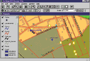 In cities worldwide, street maps are commonly available. Furthermore, these maps are often rendered in digital GIS formats. However, Karachi confronts a very different situation. No accurate, up-to-date street maps exist in hard copy or digital formats--other than the nearly decade-old tourist guidebook consisting of 334 pages of 1:10,000-scale street maps published by the Survey of Pakistan in 1990. These maps were derived from aerial photographs and surveys conducted in the 1980s. This data has implicit limitations since Karachi has changed radically over the last decade. Although the guidebook covers the formal urban areas, it would require considerable updating. With permission from the Survey of Pakistan, MediaLink and Engineering Consultants International Ltd. (ECIL) were selected to automate initial data sets.