


|
|
||
|
|
|
|
|
|
Leveraging Our National Treasury of Digital CartographyUniversity of South Florida Explores New TIGER Map Editing ToolBy Ken Tozier, President, International Computer Works, Inc.
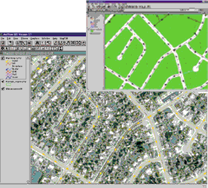
As good as this data is, there are applications that require yet a higher standard. As it pertains to the TIGER/Line files, there are few tools available outside the TIGER Operations Branch of the U.S. Bureau of the Census specifically designed for enhancing these files. To this end International Computer Works, Inc. (ICW), an authorized Esri Business Partner, developed the MapEdit ToolKit, which empowers the user to spatially enhance and attribute enrich TIGER/Line files while maintaining the topological integrity of the file. Beyond the availability of quality software for enhancing the TIGER/Line files, there is a need for people who understand how to make the enhancements. On November 5, 1998, a donation by ICW was put into classroom use at the University of South Florida (USF) in Tampa, Florida. ICW donated a 15-user license to the Department of Geography for use in their GIS lab. ICW wrote MapEdit as an extension for use in ArcView GIS. The combination of MapEdit and ArcView GIS permits the department to use an economical desktop object-oriented GIS product to perform topologically correct edits on TIGER/Line files.
Along with software, the department received manuals in both hard copy and PDF file format. Additionally, several themes that serve as support data were included. The documentation is written around the use of these themes. These themes provide alternative backdrops for use in enhancing the TIGER/Line files for the City of Manassas, Virginia. The themes consist of U.S. Census TIGER/Line files for Manassas along with City-wide coverage for edge of pavement and parcels, both created by the City Engineering Department, a 10-meter SPOTView Image provided by SPOT Image, and one-meter digital orthophotoquads produced by the United States Geological Survey. Beyond its use in the communication of GIS concepts, Dr. Reader also feels the MapEdit ToolKit could be used in a comprehensive GIS curricula. For instance, it is a natural environment within which to teach the census geography of the United States and to demonstrate the need for integrity in the georelational data model. As Dr. Reader points out, "when students realize the range and number of very real GIS applications that TIGER supports, including the collection of census data itself, they appreciate that geography really does matter." Dr. Reader went on to say, "The collection of support data enables the student to understand the importance of reconciling differences in data sets created by independent authors at different scales, such as cadastral data and TIGER." Dr. Reader also has little doubt that ICW's donation of 15 MapEdit licenses to his department will be used in the support of research, particularly where there is a need for integrating U.S. Census data with other geographic data layers. "As one of the three leading research universities in Florida and the only one in a major urban area, USF places a strong emphasis on applied urban and environmental research. The importance of GIS in such research is now appreciated by many disciplines other than geography. I feel the functionality MapEdit provides to enhance the TIGER product will likely be in demand across our campus and, indeed, well beyond." Dr. Graham Tobin, chair of the Geography Dept. at USF, agrees: "TIGER is a data product of national scope and so provides a universal resource for analyzing diverse locales. The act of ICW providing our GIS facility with MapEdit licenses is an example of how the private and public sectors can work together to educate the next generation of students." To this end, ICW is interested in talking with representatives of other major universities who would like to implement a program similar to the USF experience. For more information, contact Ken Tozier, ICW (tel.: 813-988-0434, E-mail: iworks1@tampabay.rr.com), or Steven Reader, Ph.D. (tel.: 813-974-4943, E-mail: sreader@chuma1.cas.usf.edu). |
 Among the numerous phenomena distinctly characteristic of the United States is the availability of an abundance of free to low-cost comparatively high-quality digital map data. This data is authored at every level of government. The federal government is the largest depositor and views their data as residing in the public domain. Among the authors at the federal level, the United States Bureau of the Census has the most extensive digital coast-to-coast national-scale to street-level maps with attributes--the Topographically Integrated Geographic Encoding and Referencing (TIGER)/Line files. Demographic data can be linked to TIGER maps for purposes ranging from determination of political representation to site location for fast-food restaurants.
 Dr. Steven Reader, assistant professor of Geography and director of the GIS Laboratory, is responsible for introducing the use of MapEdit into the senior-level cartography course. Dr. Reader notes, "The MapEdit ToolKit is useful in a classroom setting because it facilitates the introduction of GIS concepts on several levels. From an instructor's viewpoint it can be used to illustrate topology, scale, map generalization, conflation, address geocoding, and spatial data editing, and achieves this within a software environment (ArcView GIS) that students are familiar with."