|
|
||
|
|
|
|
|
|
Lycoming County, Pennsylvania, Organizes Groundbreaking EventCounterterrorism Exercise a Success Using GISIt was President Clinton who communicated a message of preparation as a key measure against terrorism in the United States. His theme was simple: by careful preparation, the U.S. sends a message that attacks will never accomplish the goals of their perpetrators. Agencies are now embracing the message. On May 21–22, 1999, the Lycoming County, Pennsylvania, Division of Public Safety; state, federal, and local government agencies; and the private sector participated in a major anti-terrorism exercise. Lycoming County, which has within its borders several large manufacturing companies and major freeways and other transportation corridors, served as an excellent backdrop for the counterterrorism exercise.
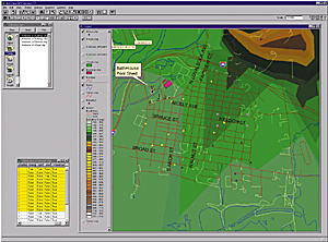
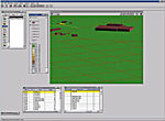
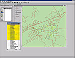
The two-day occurrence involved planning and mitigation for several terrorist scenarios including a kidnapping operation, a terrorist siege of a major building, and chemical–biological threats to the community. The exercise involved local, state, and federal law enforcement agencies; various bureaus of correction agencies; Pennsylvania Emergency Management Agency; Pennsylvania National Guard; local Fire, EMS, EMA, and HazMat agencies; elected officials; and numerous others. "Federal emergency response agencies challenged counties, in a sense, to develop counterterrorist measures in the event of an emergency," says Ted Kriner, chief emergency preparedness planner, Division of Public Safety, County of Lycoming. "We started out with various educational courses. The exercise was a natural extension of those courses and the exercise really worked out well for all involved." Terrorism in Rural LocationsLycoming County, located in central Pennsylvania, is the largest land mass county in the State. County organizers of the event were familiar with successful mitigation plans in major metropolitan areas, but a need existed for similar mitigation efforts in less populated areas that could still serve as a target for terrorism. In such an event, many local, state, and federal agencies would have to work together in an integrated fashion to perform several tasks under one umbrella. "The goal was to determine what the current capabilities of County personnel were to respond to terrorist incidents," says Barry C. Hutchins, network administrator, Division of Public Safety, County of Lycoming. "We also wanted to involve many diverse agencies, which sometimes don't get a chance to work with each other." The ability to retain the advanced training and investigative efforts of these agencies is the first and most fundamental necessity in combating terrorism. Yet somewhere in this equation, technology can play a crucial role as well. "Our command system needed to be able to handle a large, multiagency incident, and to that end we needed to test our communications and coordination between agencies," says Hutchins. "Some of the integration of these organizations involved effectively using geographical related information. The GIS data and Esri software helped us be successful in this effort." The ExercisesSeveral different counterterrorism scenarios were played out. For the first scenario, which involved a terrorist kidnapping, ArcView GIS was used to show the building where the hostage was being kept. Using the advanced GIS visualization and analysis techniques, police could more accurately prepare operational plans that took into account difficulties the police might encounter. By mapping information managed in the County's 911 system, which included precise residential data of surrounding areas, users could determine the number of people who might need to be evacuated during the tactical operation, including the number of emergency personnel, ambulances, and other medical equipment needed to provide an effective evacuation. In the tactical planning conducted by law enforcement agencies to deal with the kidnapping-hostage situation and the many different variables involved, the model created using ArcView 3D Analyst gave users a "birds-eye" view of the terrain. Based upon building height data from tax records, the building footprints from digital orthophotography of the area were created and then extruded to their approximate heights using ArcView 3D Analyst. The digital orthophotographs were overlaid onto a three-dimensional coverage that had been built from the digital elevation model (DEM) of the operational site (the DEM used for the exercise had been downloaded from the USGS Web site and, using ArcInfo map projection utilities, was put into the same map projection as the Lycoming County GIS data). Day two of the exercise proved equally successful. GIS was used for a number of services. Using ArcView 3D Analyst again, a tactical plan was generated for seizing a drug lab producing methamphetamines. Building locations, line-of-sight, and object locations such as trees, a water tower, and other obstructions were integrated for generating a model of the premises. The location of law enforcement personnel, equipment, entry points, and line of movement assessments were all generated prior to a single agent being deployed.
Additional scenarios involved managing possible chemical and biological agent threats. The Incident Command Center, where the GIS was located, received considerable input from two separate threat locations. GIS users were able to predict the number of citizens and households that would be affected by the potential hazardous releases. Users were also able to estimate where the hazard would travel and timetables for how long it would take to evacuate the areas. All of this was done on the fly. Additional GIS services were performed as well. "We plotted the locations from actual crime reports within the County and looked at where clusters of incidents took place," says Hutchins. "In one area we could actually see a route or pattern of travel for a specific set of police incident classifications. We also discussed and demonstrated how we could look at the location of the theft of certain chemicals within the area and show that the pattern of thefts centered around a certain location. This was more of an aside in order to show officials some of the additional things they could do with the technology." According to organizers, a large part of the success of the various exercises was due to the GIS and related data collected during the County's two year Enhanced 911 Addressing Project. This database contained information on individual property owners and occupants including the number of occupants in households, the number of handicapped occupants in households, previous incident information, and more. "We realized that GIS would be a terrific tool for these exercises because we had built a tremendous amount of information already," says Hutchins. "People were used to using maps for tactical planning in many of these kinds of scenarios. With the GIS, we could not only provide up-to-date maps on the fly, we could also do a lot more with the map information than you ever could before." For more information, contact Barry Hutchins, network administrator, Lycoming County Department of Public Safety, 2130 County Farm Road, Montoursville, Pennsylvania 17754-9621 (tel.: 570-433-4461, ext. 131; fax: 570-433-4435; e-mail: bhutchin@epix.net). |