


|
|
||
|
|
|
|
|
|
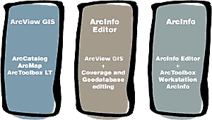
Esri's New ArcGIS Product FamilyBy Dr. David J. Maguire, Director of Products, EsriThis article introduces a new name and concept for Esri GIS software. At the end of 1999, Esri released the first phase of the ArcGIS system, a new, integrated architecture for GIS products. This architecture provides a scalable and comprehensive solution for building and serving GIS applications of all types within all mainstream computer architectures. Phase I involved the release of ArcInfo 8 with ArcSDE. Phase II was marked by the release in spring of ArcIMS and allowed the deployment of Esri software on the Internet. ArcIMS includes ArcExplorer, ArcIMS Viewer, and the ArcIMS application services. At the 2000 Esri International User Conference, Esri will release beta versions of the next installment of the ArcGIS system. ArcInfo 8.1, ArcSDE 8.1, and ArcView GIS 8.1 are part of ArcGIS Phase III. 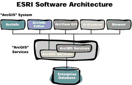 The ArcGIS Product Family. The ArcGIS product family comprises a scalable set of state-of-the-art Desktop GIS and integrated GIS application services products. The Desktop GIS clients available at ArcGIS 8.1 are ArcView GIS, ArcInfo Editor, and ArcInfo.
ArcView GIS 8.1 is the next generation of Esri's ArcView GIS. The numbering of ArcView GIS has jumped from 3.2a to 8.1 to indicate that this is a major increase in functionality and that ArcView GIS 8.1 is built from the same common core technology as ArcInfo 8.1 and ArcSDE 8.1. All of these products are designed to work in close concert with each other. ArcView GIS 8.1 provides the same base functionality as ArcView GIS 3.2a, with some notable improvements such as the new ArcCatalog application for browsing and managing data, on-the-fly coordinate and datum projection, customization with built-in VBA, extensive range of new editor tools, support for annotation, and much more. ArcView GIS 8.1 comprises the ArcCatalog, ArcMap, and ArcToolbox (light version only) applications, with some significant improvements since ArcInfo 8.0.2. ArcGIS 8.1 includes two flavors of ArcInfo: ArcInfo Editor and ArcInfo Professional. ArcInfo Editor is primarily designed for geodatabase creation and editing. It comprises complete versions of ArcMap, including the full object editor, and ArcCatalog. With the ArcInfo Editor you can create and update databases and database schema for shapefiles, coverages, personal geodatabases, and enterprise geodatabases (that is, all Esri-supported vector databases). ArcInfo Editor also comes with complete mapping and data query tools. ArcInfo Professional is the most functionally rich product in the ArcGIS product family. It includes all the capabilities of ArcView GIS and ArcInfo Editor, as described above. In addition, it includes a complete ArcToolbox application and a full version of ArcInfo Workstation (ARC, ARCEDIT, ARCPLOT, ARC Macro Language, and all extensions). ArcInfo is the complete GIS data creation, update, query, mapping, and analysis system. ArcGIS 8.1 will see the introduction of the first next generation product extensions. Functional extensions available at ArcGIS 8.1 include ArcView Spatial Analyst, which combines the ArcView Spatial Analyst ArcGIS 8.1 continues the trend of complete integration of Desktop GIS clients with ArcSDE, Esri's database gateway and application services product. ArcGIS 8.1 introduces a new deployment configuration for using the ArcSDE technology. All Esri clients include the ArcSDE database gateway technology for read-only direct connection to all supported databases (coverages, DB2, Informix, Oracle, and SQL Server). There is no additional charge for using this direct connect technology in ArcInfo, ArcInfo Editor, and ArcView GIS. Read-write access to geodatabases still requires purchase of ArcSDE. 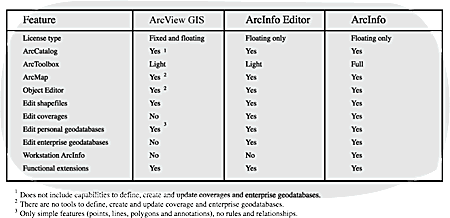 Comparison of ArcGIS 8.1 Desktop GIS clients. ArcGIS clients are available in two different license types: stand-alone and network. A stand-alone seat is one that is tied to a specific computer machine. Each computer in an organization that will run the software will require an install and licensed copy. Maintenance and upgrades for stand-alone seats are available on a pay-as-you-go/upgrade or annual maintenance basis. ArcView GIS is the only product available as a stand-alone seat. This is the same model used in ArcView GIS 3.2. A network (floating) seat will require installation of a license manager on at least one network machine. Annual maintenance is required for floating seats. ArcView GIS is available as stand-alone and network seats; ArcInfo Editor and ArcInfo are available as network seats only. ArcIMS adds Internet services to the ArcGIS system. ArcIMS includes two clients and a suite of application services. The ArcIMS browser-based viewer and stand alone ArcExplorer viewer are lightweight Web clients. They are designed to work in a complementary fashion with other ArcGIS desktop clients. With the recent release of ArcIMS 3, Esri has integrated the Internet and World Wide Web into the ArcGIS system. ArcIMS 3 provides a suite The ArcGIS system is designed to interoperate with existing enterprise technology, applications, and databases. Through the use of open standards, such as COM, XML, and SQL, ArcGIS can communicate with enterprise databases (with or without spatial extensions), Web servers, and complementary applications for enterprise resource management, customer relationship management, and land and property maintenance. In summary, ArcGIS 8.1 is a major breakthrough in the GIS field. ArcGIS is a comprehensive, integrated scalable system designed to meet the needs of a wide range of GIS users. It is envisioned that user sites will deploy multiple ArcView GIS, ArcInfo Editor, ArcExplorer, ArcIMS Viewer seats, and ArcSDE/ArcIMS application servers to meet their needs for scalable GIS solutions. |
 and ArcInfo GRID capabilities; ArcView 3D Analyst, which combines ArcView GIS 3D Analyst and TIN capabilities; and GeoStatistical Analyst, a new extension for geostatistical analysis (surface interpolation and analysis with kriging). A further key part of ArcGIS 8.1 is a series of data models that extend the software into specific application domains. The first of several data model extensions to be introduced is ArcFM Water. This is a geodatabase data model for water, wastewater, and storm water. It comes complete with a graphical model, physical database design, test database, and manual. Other data models covering electric, gas, streets, and environmental permitting will follow.
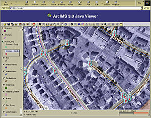 of services for working with geographic information over the Web. A very significant new capability is that all ArcGIS desktop clients (ArcInfo, ArcInfo Editor, ArcView GIS, ArcExplorer, and ArcIMS Viewer) can now dynamically stream raster and vector data across the Web from an ArcIMS server. These new layer types behave exactly like all other layers once they have been brought across the network; that is, they can be symbolized, mapped, queried, edited, and analyzed just like local data. They can also be saved in local formats for later use.