


|
|
||
|
|
|
|
|
|
Esri Technology Brings Real-Life Crime Mapping to TelevisionMapping CBS's New Crime Drama—"The District"ArcView GIS has made it to prime-time television on "The District," CBS's new crime drama starring Craig T. Nelson. Debuting this "TV audiences are going to see fully realized maps that are true to the show's reality," says Lew Nelson, law enforcement industry manager, Esri. "Understanding this is a television program, we're working with 'The District' to represent as accurately as possible how GIS is used in law enforcement. This is special and unique to television. Whether it's resource deployment, mitigating a community policing issue, a hostage issue, a series of related crimes, or any type of threat to the community, the maps used for the television show are the kinds of maps used by real crime mappers." Craig T. Nelson plays Jack Mannion, the new police commissioner of Washington, D.C., brought in to overhaul an antiquated law enforcement agency
Above right: In episode two, ArcView GIS shows the crime incidence in a neighborhood. Real policing techniques and technology applications bring an authentic perspective to the show. While the characters and story drive the show and are always in the foreground, "The District" requires solid crime analysis capabilities. For this, crime mapping GIS was chosen by the producers. COMSTAT and GISPart of an overall, comprehensive system known as COMSTAT, ArcView GIS is the computer mapping engine that allows the characters in "The District" to map such things as the locations of murders, armed robberies, guns seized, and more. COMSTAT is a process that forces accountability and responsibility by requiring police commanders to be intimately aware of crime and crime patterns in their areas. It requires dynamic, computer-based mapping to accomplish this. Used on the set of each episode of "The District," COMSTAT is in fact a real-world system used today by top law enforcement agencies to more effectively combat crime. Jack Maple is the real-life hero who made the COMSTAT
Above left: For episode three, ArcView GIS was used to map the locations and number of crimes during the day and night and then to map the deployment of patrol officers during the day and night. Inset: The maps clearly show that crime peaks during the night, whereas most officers are deployed during the day. How GIS Made It to Prime-Time TelevisionThe producers of "The District" boast a distinguished feature film resum�. Executive producers Terry George (In the Name of the Father, The Boxer), who also wrote and directed episodes of "The District," and Denise DiNovi (Batman Returns, Message in a Bottle) bring CBS's new, prime-time crime drama to life. Staff from "The District" contacted Esri before production began to learn more about computer mapping and how it can be used as an integral part of the show. Esri saw this as an opportunity to give GIS a prime-time audience and offered to provide software and technical support. "They had been using a graphic artist to produce maps used for the show," says Linda Hecht, director of marketing, Esri. "But they soon realized they wanted something more technically accurate, something that had the look and feel of the latest technology that was really used by law enforcement agencies." "It's exciting that anyone familiar with GIS, whether working in government, environment, Business, or in some other market, can see a show where it is recognized that GIS is critical and has real value," says Nelson. "The District" debuted October 7, 2000, and is scheduled to run every Saturday at 10:00 p.m. Pacific and Eastern time, 9:00 p.m. Central and Mountain time. "The use of ArcView GIS grows in each episode," says Esri's John Calkins working on the set of "The District." "For instance, episode four includes ArcView GIS, ArcView Network Analyst, ArcView Tracking Analyst, ArcView 3D Analyst, and even the Geography Network. In every episode after the pilot, there is an identification of a problem, and mapping is used to identify the problem and to frequently address and mitigate the problem. We'd like to continue to support 'The District' in any way we can as long as the show airs." For more information contact Karen Hurlbut, marketing communications manager, Esri (tel.: 909-793-2853, ext. 1-1582; e-mail: khurlbut@esri.com). |
 fall, "The District" is based on the experiences of real-life law enforcement hero Jack Maple, who is the show's top law enforcement consultant, and follows a fictional renegade police commissioner and his staff as they work to reduce crime in the nation's capital.
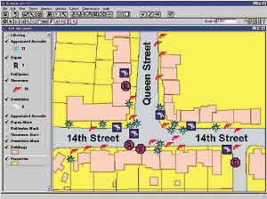 ill-equipped to deal with the problems of a sprawling, crime-ridden city. Mannion works to clamp down on crime by empowering "The District" with new, powerful technologies including computer mapping. Lynne Thigpen plays Ella Farmer, Mannion's top assistant, who operates the various technologies and GIS.
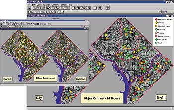 process famous. Today, law enforcement agencies such as the New Orleans Police Department use COMSTAT or similar systems. For audiences, the chance to witness powerful mapping tools as part of a TV crime drama isn't the stuff of smoke and mirrors. This kind of computer mapping, used fictionally for "The District," is the exact kind of futuristic-looking technology used by leading law enforcement agencies.