


|
|
||
|
|
|
|
|
|
Imagery in Urban Planning
Combining remotely sensed imagery with ancillary data in ArcView GIS (as the Berkeley, Charleston, and Dorchester Council of Governments did--see main story) gives urban planners a highly detailed, accurate, up-to-date background for all other GIS vector layers. Planners can bring a raster image up on a computer screen and easily identify GIS data layers (e.g., building footprints and street centerlines) without expensive, time-consuming ground surveys or the implementation of a multimillion-dollar revision of the entire GIS database by a third party vendor. Above right: Beaufort County, South Carolina (just south of Charleston), is using imagery to analyze urban development and plan for future growth. Top: A color infrared aerial photo from January 1994. Bottom: This image was collected by a Calibrated Airborne Multispectral Scanner in September 1996. (Image courtesty of Steve Schill of the University of South Carolina Remote Sensing Laboratory.) Combining a digital picture of ground features with regular vector GIS data is useful in zoning and land use planning decisions, cadastral mapping, basemapping, and plan updating, while enabling industrial site and economic development planners to simultaneously access digital imagery and numerous GIS vector layers (hydrography, property lines, soil types, etc.) and related tabular information (stream class, parcel attributes, soil characteristics). Satellite imagery is readily available for numerous years, seasons, and illumination conditions; one image can be created by combining scenes to form a mosaic for an entire county area, simplifying file management and lowering data acquisition costs; the availability of multispectral bands provides a means for numerous forms of spatial analysis; and modification and clarification of specific bands can provide insight into physical characteristics of the land surface. Scanned, rectified imagery is a practical source for Esri users looking for a cost-effective method for updating and managing their ArcView GIS database. Advancements in scanning technology, reduced computer file storage space costs, and computer performance improvements have combined to make imagery a viable tool for many urban applications. ERDAS software is tightly integrated with Esri software and formats, making it the number one geographic imaging choice of Esri users. For more information, contact ERDAS (tel.: 404-248-9000, toll-free tel.: 1-877-GO ERDAS) or visit ERDAS on the Web at www.erdas.com. |
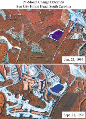 Image-based information products are valuable tools in urban planning. Remotely sensed imagery provides urban planners cost-effective, rapidly acquired, repetitive data covering extensive areas. Imagery classified into land use and land cover categories yield insight into the earth's surface features and the land consumption processes at work.