April - June 2006
April - June 2006 |
||||||||
|
|
||||||||
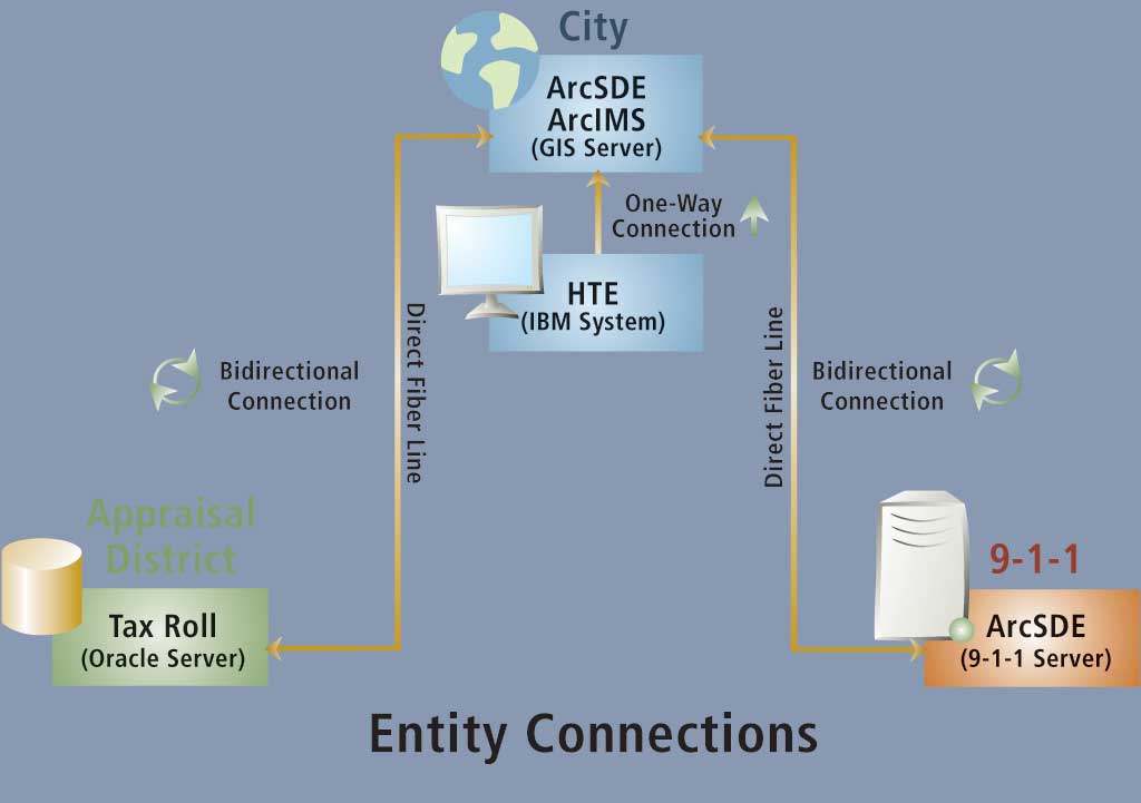
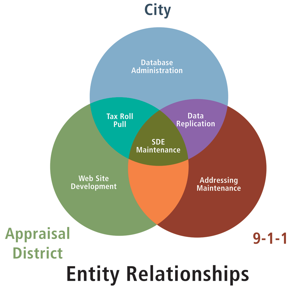
The three entities had always worked well with each other and needed to share data on a regular basis. However, the data was not standardized across the organizations because it was stored and maintained in three different places by different people. "We were all using the same software systems but they didn't talk to each other," said Jan Funderburgh, GIS/MIS operations manager for Smith County 9-1-1. "We faced different interpretations of maps and duplication of work." The GIS personnel from the three entities knew and respected each other. They worked out a solution at the middle management level and presented the plan to the upper management of each organization. "Each respective board approved it, and the city's Information Technologies Department was instrumental in getting technology in place so that all this could happen," said Dan Allee, GIS coordinator for the city of Tyler. The city, appraisal district, and 9-1-1 district signed an interlocal agreement, which also included Smith County, so that the county would be able to join the common database when it is ready to do so. Each organization was able to bring its unique expertise to the project. The appraisal district had strength in Web site design and maintenance. The city acted as the site host. "The appraisal district maintained an active GIS database with public access through our Web site, so it was logical that we provide that insight," said Michael Barnett, chief appraiser of the district. Smith County 9-1-1 contributed standardized street addressing and the city's database administration capabilities. "Although we still all have our own distinct GIS entities, we are able to pool our resources and utilize each other's strengths in knowledge and personnel for the common good of all entities," said Allee. The biggest technical hurdle the project faced was configuring a server with licenses that would work for three entities instead of just one. To handle this challenge, city staff took the Esri ArcSDE training course and hired an Esri consultant to work out any geodatabase glitches. Fiber-optic lines connect all entities to the single ArcIMS server maintained by the city of Tyler. A four-processor server, with a four-processor ArcSDE license, was used to make sure there was enough horsepower necessary to run all agencies and all Web sites. Each night, the city performs backups on the fiber connections, and the database is totally replicated to a secure area at Smith County 9-1-1.
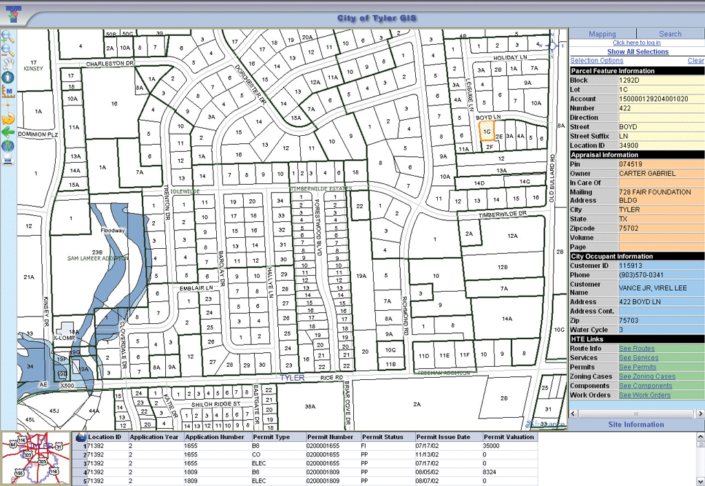
GIS was integrated with the citywide database. This database provides building permit, water utility, solid waste, and planning and zoning data to all entities. By integrating GIS into the appraisal district's computer-aided mass appraisal system, all entities can access ownership, building, and valuation information. It took about six months to work out the initial configuration. The biggest delay was waiting for the fiber construction to the new 9-1-1 building. However, by 2003, the three entities had created one geodatabase that linked all the data, kept it in a standardized format, and allowed all three organizations to interact rather than just swap CDs containing data that was outdated by the next day. For the last two years, the entities have benefited from a cooperative exchange of data. They have standardized account numbers, line work, addressing, and street names. "The most unique aspect to all this was being able to do our job much more efficiently by having live access to everyone's data," Allee said. "There is now only one copy of shared data layers such as parcels, streets, and zoning." All three organizations agree this collaboration saves time and money by eliminating redundancy in work and duplication of database servers, hardware, and software. "Now all the data merges together—there are instant updates between three separate entities with three different governing bodies. It is amazing," said Funderburgh. She said the groups are open-minded and agree to ongoing changes in the database on a priority basis. "My main goal is to get more data to the 9-1-1 dispatchers so we can find people and get them help quicker," said Funderburgh. This integration not only benefits the departments within each entity but also allows more public access. "If members of the private sector can get the information they want off the Web site instead of going to the appraisal district office or city hall, then we have saved their time and our time," Barnett said. The groups pledge to look for more common areas that can be streamlined and combined to provide better services to each entity, save taxpayer money, and make the database stronger.
Barnett hopes the collaboration will eventually help define the boundaries of Smith County. Currently, the boundaries are undefined because they are set by rivers that move. "As the common database becomes a greater resource through the years, it will also obtain a higher degree of accuracy," he said. "Being able to put together information in a timely fashion is critical to our success. Our focus is to provide data that is meaningful, accurate, and easily accessed," Barnett said. He sees it eventually becoming a central resource tool for all county municipalities. For more information, contact Dan Allee at dallee@tylertexas.com or visit www.smithcountymapsite.org. About the AuthorKristi Flippin is the special projects coordinator for the city of Tyler. She has a bachelor's degree from the University of North Texas. |