A Better Way to Handle GIS Data
By Mehdi Mashud Khan, GISP; Angela Kneece; Ishwari Sivagnanam; and Jared John Shoultz
South Carolina Uses Server-Based GIS
The South Carolina Department of Health and Environmental Control (SC DHEC) has many GIS users with different skills and needs. It has adopted a server-based approach to GIS to better serve these users. This article compares traditional GIS with server-based GIS in terms of data storage and the distribution of GIS applications. It discusses how to develop a GIS system that can scale to match growing GIS needs without complex renovations and GIS data security.
 |
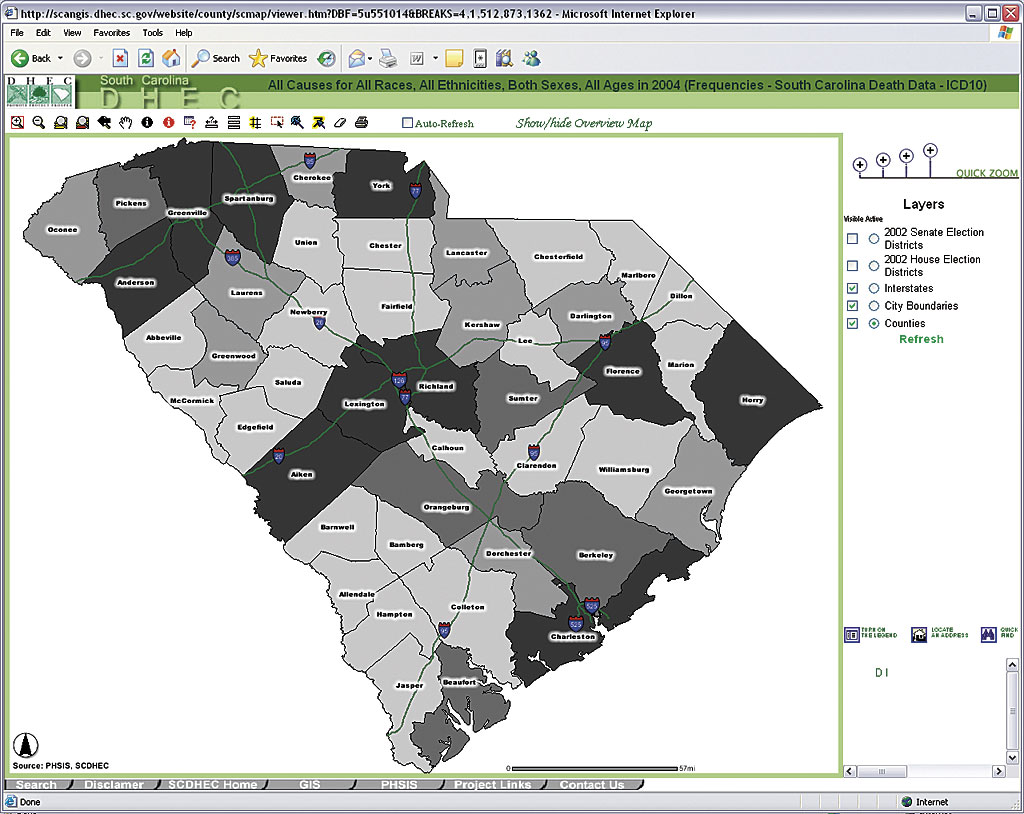
| The division's server-based GIS combines GIS Web publishing using both standard and customized Internet map services. |
GIS personnel are responsible for simultaneously creating and maintaining spatial data, authoring maps, and conducting spatial analysis based on an organization's business needs while leveraging that spatial data throughout the enterprise. To do this, a GIS department needs a sound GIS implementation plan for carefully selecting the software and hardware most suitable to the size, volume, and type of workload.
The answers to three basic questions shape the foundation of a GIS:
Who will create the data and how will it be created?
Where and how will the data be stored?
How will the data be published and/or made available to the end users?
In a small organization with limited personnel and a less diversified end user group, GIS data is stored locally and often administered by a GIS manager. In this situation, using a traditional GIS with desktop GIS software may be more cost-effective. Data can be stored in a local or shared drive as file-based datasets such as coverages or shapefiles or in a personal geodatabase. Since data is administered, edited, and used only by a few people who are in close proximity, problems such as concurrent data use conflicts can be resolved easily. Data distribution is also simple because the needs of the user community are known and specified, and the GIS group does not need to deal with a wide variety of data requirements.
In a large, complex organization where multiple GIS groups are located in different interdependent branch offices that are responsible for administering data within specific contexts, it is a real challenge to minimize redundancy while ensuring that the right data is accessible in a timely and efficient manner. With hundreds of remote offices and thousands of internal and external GIS users at different levels of expertise and needs, the Division of Public Health Informatics at SC DHEC had to overcome multiple barriers while designing its enterprise GIS.
The division had to
- Ensure only the most recent GIS data was accessible to end users. Users should not be misled by multiple versions of the same data that is maintained by different branch offices.
- Ensure an acceptable level of computing performance in terms of speed, accessibility, and reliability.
- Provide sensitive data to authorized users with appropriate protection to the sensitive elements while serving the portions of the same dataset that have no restrictions to general users.
- Facilitate interdepartmental coordination through data sharing.
- Provide seamless application and system updates and upgrades with minimal end user impact.
- Ensure data is collected and maintained in a standardized format that allows interdepartmental overlays
One solution was to implement a server-based GIS that could cope with all the above concerns. Server-based GIS can be defined as centrally hosted GIS computing. Internal GIS capabilities are shared with users on the agency network while a Web-based platform is also maintained for external users. GIS users have the capabilities to connect to the central GIS servers using desktop GIS software, Web browsers, custom applications, and mobile computing devices.
The division's server-based GIS is a combination of GIS Web publishing using both standard and customized Internet map services furnished using ArcIMS, ArcSDE with a relational database management system (Microsoft SQL Server) for data storage, and a centralized shared GIS server using ArcGIS Server. Additional components, extensions, and customized applications that consume GIS information are also a big part of the overall picture.
Data Storage, Sharing, and Protection
The division's GIS data is stored in a geodatabase using ArcSDE and Microsoft SQL Server. ArcSDE can be phased in as a spatial data access server that allows for administering spatial data stored in a relational DBMS and provides access to data required for client applications such as ArcGIS Desktop, ArcIMS, ArcGIS Server, and custom applications. Because spatial data is stored as tables in a DBMS, the strengths of a DBMS (data storage, data integrity, and data security) can also be applied to the spatial data. By transferring almost all GIS data into the ArcSDE geodatabase, the division established a centralized resource for geospatial data that can be accessed through the department's network, intranet, and Internet by various GIS applications and functionalities designed to serve its many GIS users.
Different divisions of the agency are sometimes responsible for different parts of the same data. For example, the Division of Public Health Informatics creates and maintains the spatial locations and other spatial information on health facilities while the Division of Health Regulations maintains information on licensing, types of facilities, contact information, addition or cancellation of facilities, and other relevant information for the same health facilities data.
Therefore, Public Health Informatics needs to periodically update the layer with the information collected from the Health Facilities Regulation. Data Transformation Services (DTS), the built-in import functionality of SQL Server, could be used with the ArcSDE geodatabase, making it easy to create a process that would import the required field values from the Health Regulations database and update the existing health facilities data. Moreover, the Java API for ArcSDE makes it possible to geocode and add a new facility on the fly or delete an existing facility from the layer whenever a license is added or cancelled. This makes the data sharing process automatic and transparent while avoiding any issues related to data maintenance, ownership, and integrity. Neither division has write access to the other division's database, and DHEC and the general public receive real-time, value-added data resulting from intra-agency cooperation and collaboration. Similar processes are also laid down with other participating divisions.
 |
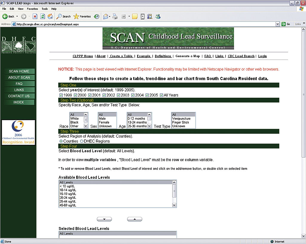
| South Carolina Assessment Network (SCAN), an application developed by the division, uses ArcIMS for Internet mapping, Microsoft SQL Server/ArcSDE for data management, ASP.NET and HTML for programming and interface design, and XML for data exchange. |
Due to the nature of the confidential and restricted access to data that must be maintained, privacy protection has always been a major concern. DHEC customers have different GIS data needs and levels of expertise and range from professors, researchers, and health professionals to ordinary citizens. The ability to create spatial views in an ArcSDE geodatabase and control user rights through SQL Server has made it easier to deal with data protection. Several spatial views are created with information that is appropriate for general users while the original layers that contain sensitive information are password protected and accessible only to higher-level users with appropriate rights.
Distributing Data and GIS Functionality
Historically, most typical data requests for geospatial and tabular data are provided to DHEC through manual processes such as phone calls or on-site visits. Traditionally, these requests would be handled by office personnel. This would require intermediate steps, discussions, and, often multiple revisions before the final product was created. The advent and subsequent rise in Internet use opened new avenues for data requests as well as a whole new group of data requestors. Now, with the help of built-in functionalities and customized ArcIMS applications that use .NET technology, Java, and Active Server Pages (ASP), a user can generate custom maps and tables in real time. The data delivery mechanism is streamlined, user friendly, and cost-effective.
The South Carolina Assessment Network (SCAN), an application developed by the Public Health Informatics Division, uses ArcIMS for Internet mapping, Microsoft SQL Server/ArcSDE for data management, ASP.NET and HTML for programming and interface design, and XML for data exchange. Statistical and geographical results are generated on the fly using ASP.NET's built-in algorithms. Internet GIS allows users to drill into categories; modify requests; add spatial layers; and obtain supplemental information that includes animated formula calculations, help screens, and definitions. SCAN has significantly decreased the number of requests coming into the division while dramatically improving response time and data availability. This has enhanced the division's ability to answer more detailed requests and branch out into other areas such as homeland security, emergency response, and data collection/augmentation.
ArcGIS Server, the latest addition to the division's server-based GIS, allows enterprise GIS applications to be built that can be centrally managed and accessed via Web-based interfaces, custom applications, or traditional desktop GIS. Built on ArcObjects, ArcGIS Server can provide all the strength of advanced GIS functionalities in a distributed multiuser setting.
The Carpool application is a good example of a distributed GIS application served via the agency's intranet. This application allows employees to enter their addresses and contact information through a user-friendly interface. These addresses are automatically geocoded in real time and displayed in a map along with the road network, remote offices, locations of other participating employees, and other relevant information. By defining an employee's proximity to other program participants, employees can arrange to carpool to or from work. This program saves money and creates a better environment.
GIS services can also be distributed using Web services and ArcGIS Server. A GIS Web service may be defined as a software component containing GIS functionalities that can be described by Web Services Description Language (WSDL) and can be accessed via SOAP over HTTP. The division serves its composite geocoding Web service through ArcGIS Server, which helps agency staff geocode data without having GIS software or prior GIS knowledge.
Conclusion
The operational complexities associated with a multidivisional agency and the growing need of GIS data led the Division of Public Health Informatics to server-based GIS. Centralized capabilities of server-based GIS made it easier for the GIS and system administrators to upgrade or update the system, administer users to protect data confidentiality, and provide GIS services quickly to an ever-changing number of users. Server-based GIS saves both time and money and has proven to be very effective for the current GIS workload of the division. For more information, contact Mehdi Khan at 803-898-3644 or khanmm@dhec.sc.gov.
Primary Author
Mehdi Mashud Khan, GISP
GIS Manager and Analyst
Division of Public Health Informatics
South Carolina Department of Health and Environmental Control
2600 Bull Street
Columbia, South Carolina 29201
Coauthors
Angela Kneece
GIS Analyst, Division of Public Health Informatics
SC DHEC
Ishwari Sivagnanam
GIS Analyst, Division of Public Health Informatics
SC DHEC
Jared John Shoultz
Director, Division of Public Health Informatics
SC DHEC
|