Our Place in the World
The Citizen Potawatomi Nation
 |
| The Citizen Potawatomi Nation, a federally recognized Native American tribe headquartered in Shawnee, Oklahoma, has incorporated GIS into its governmental structure and services. |
Retaining sovereignty can be a challenge for tribal governments. Although tribes once held contiguous land bases, over time these holdings have often been reduced to a checkerboard jurisdiction. This is the situation that the numerous Native American tribes and Indian Nations within the state of Oklahoma face.
The state of Oklahoma, with a greater population of Native Americans per capita than any other state in the United States, is currently home to 38 different tribal governments. Formerly known as Indian Native American Tribes, it does not have a true reservation system although it has a federally recognized reservation, the Osage Nation Reservation, headquartered in Pawhuska (also known as Osage County). With that exception, Traditional Jurisdictional Areas (TJAs) have pretty much become just another political boundary that crosses borders with school districts, municipal boundaries, and the like and are important only to the tribe or tribes that originally inhabited the area.
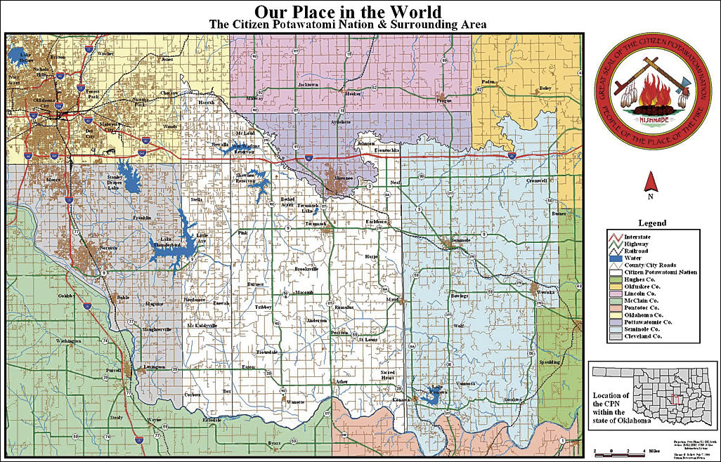
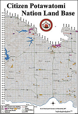
To get a firm grasp on their holdings and the world they now share, the Citizen Potawatomi Nation (CPN) has incorporated the use of GIS into its government structure and services. The CPN is a federally recognized Native American tribe headquartered in Shawnee, Oklahoma. The legal description of its TJA defines an area spanning from "North of the Canadian River, South of the North Canadian River, East of the Indian Meridian & West of the Seminole County Line." Originally, this area encompassed 900 square miles. However, through time and various government processes, the land actually owned and/or controlled by the tribe has been greatly reduced and has developed a checkerboard design. The author has used GIS to display all governmental components on a single platform. This has given the tribal leadership a better understanding of the tribe's holdings and allowed for more detailed tribal development and planning.
Hello, my name is Thomas Tollett, and I am the GIS analyst for the CPN located in Shawnee, Oklahoma. Through the use of Esri's GIS software, we are able to collect data from a wide range of sources and display it on a single platform—something, until now, this tribe had been unable to do. Almost every tribal department receives information from a separate federal entity, and it seems that each federal office uses a different format for information dissemination.
A History of the CPN
 |
| The author began developing maps to illustrate the location, shape, and size of the CPN in relation to the surrounding local, state, and county governments. |
Before I begin describing the ways the CPN is using GIS, I would like to give you a brief history of the tribe. The Potawatomi are among the wave of Algonquian-speaking people who occupied the Great Lakes region from prehistoric times through the early 1800s. Oral traditions explain that the ancient Potawatomi people were once part of an immense group that had traveled down the eastern shores of North America along the Atlantic Ocean. This large group—the Chippewa (Ojibwa), the Ottawa (Odawa), and the Potawatomi—all constituted a single tribe.
The larger group later split at Georgian Bay, Ontario, Canada, and went their separate ways. Through early historic records, it has been confirmed that the Potawatomi were living in Michigan and had established an autonomous tribal identity at least 500 years ago. Scholars have debated the origin and translation of the word Potawatomi for many years. Nevertheless, the Potawatomi people firmly believe that the Chippewa applied the term to them, meaning "the people of the fire" because the Potawatomi retained the original council fire once shared by all three tribes.
The CPN Reservation is located in central Oklahoma, between the North Canadian River and Canadian River, covering sections of three Oklahoma counties (Pottawatomie, Cleveland, and Oklahoma). The original reservation area was established by direct purchase of the CPN—the tribe was not merely assigned a land base. Headquartered in Shawnee, Oklahoma, the CPN is one of seven Potawatomi tribes or bands, and members are located in every state in the union and five foreign countries. The tribe obtained federal recognition in 1938 under the Thomas-Rogers Oklahoma Indian Welfare Act.
I was hired by the CPN in October 2003 as a GIS and environmental specialist. Previously, the tribe had employed a series of drafters and CAD operators to handle mapping responsibilities but had recently discovered GIS and wanted to move in that direction. Being fresh out of college, my only real-world experience had been a yearlong internship during my senior year. This was a great opportunity for me—just the kind of challenge I was looking for. I was very excited to get started actually designing, developing, and maintaining a tribal GIS from the ground up.
For the first couple of months, I went through the existing data that the tribe had received from contractors, government offices, and intertribal organizations as well as searched for new sources of geospatial data. It is difficult for American Indian tribes and nations to establish jurisdiction across their TJAs, but most of the basic geospatial information needed is available from various state departments and agencies. Transportation systems (e.g., roads, railroads, and bridges), political boundaries (e.g., House of Representatives, Senate, and county commissioner districts), public school districts, municipal boundaries, and a variety of other information that a tribal government might find desirable are readily available if one knows where to look.
 |
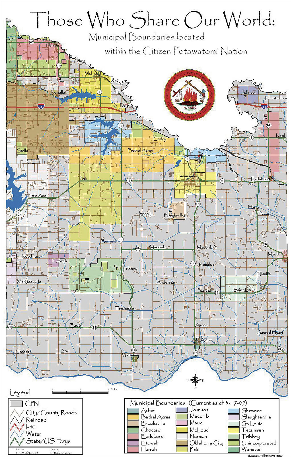
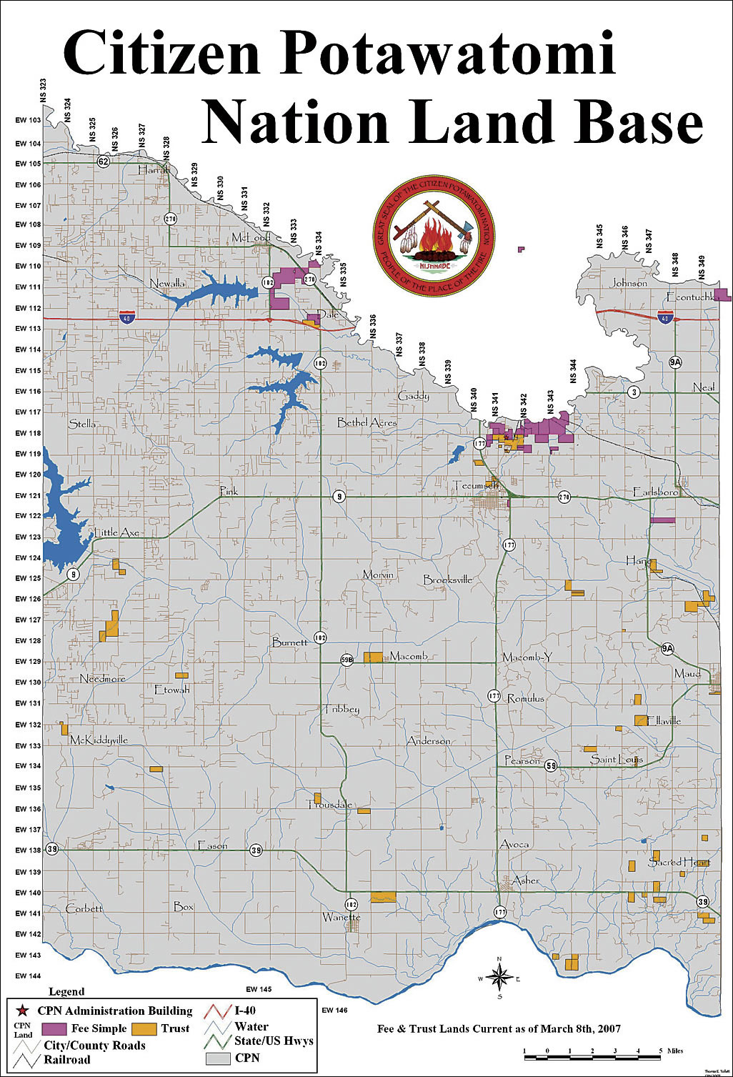
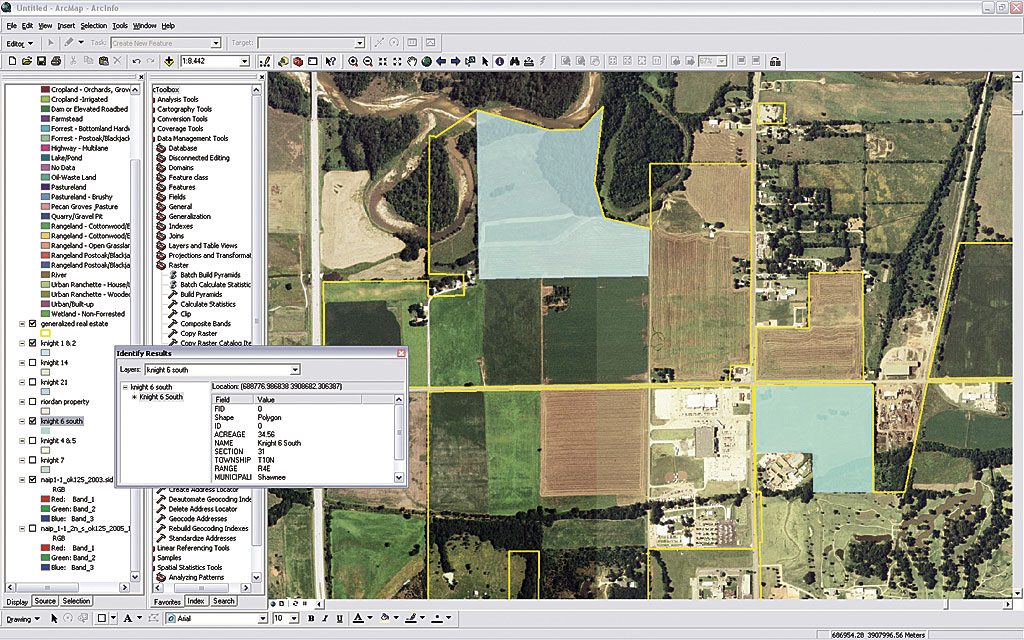
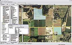
| One of the ongoing projects is mapping and creating a geodatabase for all tribal trust and fee-simple land parcels. |
After collecting the data on a state or county level, all a GIS person has to do is to extract the information that is relevant to the tribal boundary. After my data mining exercises, I created a list of the data I had found and circulated it among the tribal departments. This gave other departments a chance to better understand what I was doing and what could be accomplished with GIS in addition to letting me gain more insight on what kinds of information I was lacking and might find useful to have on hand.
At first, I began developing maps to illustrate the location, shape, and size of the CPN in relation to the local, state, and county governments around our geographic area. Some of the other maps had been made previously by different federal and intertribal groups, but none I found matched the legal description of the CPN that I had found on a copy of the original treaty. Soon I was receiving requests for more specific maps and questions on the functionality and possibility of projects from different tribal departments.
CPN GIS Applications
To date, I have worked with a number of our tribal departments on geospatial projects and have several more projects in the works. A brief synopsis of the GIS work being done or slated for the near future within some of the CPN departments and services follows.
CPN Office of Environmental Protection
- Created and continues developing the GIS database for the CPN
- Location of sampling sites, environmental hazards, site reconnaissance/planning
- Redistricting of the Oklahoma Tribal Conservation Advisory Council (OTCAC), an intertribal organization, to facilitate greater understanding and easier travel among its members
- Works with an intertribal water quality task force to map watersheds and tribal boundaries in Oklahoma in order to develop a Water Advisory Board to assist tribes in their pursuit to gain Treatment as a State status from the federal government
 |
| GIS has given the tribal leadership a better understanding of the tribe's holdings and allowed for more detailed tribal development and planning. |
Real Estate Services
Mapping and geodatabase creation of all tribal trust and fee-simple land parcels is ongoing. Development of this data will also aid numerous other tribal entities. For example, it will help the CPN Tribal Police Department establish jurisdiction; aid the CPN Emergency Management Department in disaster mitigation, planning, and recovery; and assist the tribal leadership in planning and development for the tribe's future.
Indian Reservation Roads Program
Inventory creation, development, and management of the roads included in the Indian Reservation Roads Program.
Office of Self-Governance
Creation of a series of maps and aerial photos to better convey the tribe's location, size, and impact area to assist in the grant application process.
CPN's Cultural Heritage Department
Maintenance of geospatial data in relation to the original individual allotments, creation of Tribal Family Allotment maps for the membership, and creation of maps and aerial photos to facilitate and accompany cultural/historical research.
There are numerous ways a Native American tribe can benefit from the use of GIS. I hope that this article has given you greater insight into how the CPN is using Esri's GIS technology and given you a few ideas on how to incorporate GIS into your government.
 For more information, contact For more information, contact
Thomas E. Tollett, CFM GIS Analyst Environmental/Transportation Specialist Citizen Potawatomi Nation
41707 Hardesty Road
Shawnee, Oklahoma 74801
E-mail: ttollett@potawatomi.org
Tel.: 405-878-4672
Fax: 405-878-4678
|