Summer 2009
Summer 2009 |
||||||||
|
|
||||||||
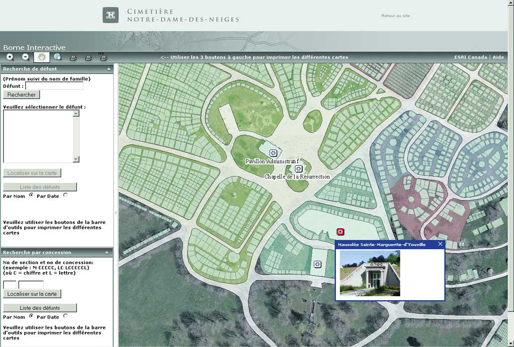
Located in Montreal, Quebec, Cimeti�re Notre-Dame-des-Neiges contains a delicate mix of heritage resources, artwork, and ecological marvels. Founded more than 150 years ago, the cemetery is home to notable institutional buildings and historical artifacts that are protected as part of Quebec's architectural heritage. A few examples include the Resurrection Chapel built in 1856, the Jarry-Henrichon House that dates to 1751, and a life-sized marble reproduction of Michelangelo's Piet� sculpture. For the past 12 years, Cimeti�re Notre-Dame-des-Neiges has been leveraging GIS technology through customized applications including an interactive information desk, an internal mapping application, and a Web mapping application. Improving the Visitor ExperienceIn the late 1990s, the cemetery began receiving phone calls and on-site requests from visitors trying to locate the graves of deceased loved ones. Cimeti�re Notre-Dame-des-Neiges is 55 kilometers in length and is the final resting place for almost one million people. Visitors can easily become lost or fail to locate the section of the cemetery for which they are searching. For many years, visitors navigated cemetery grounds using a map printed in a brochure. The map was based on plans that were developed in 1854, when the cemetery first opened, and then updated with the help of a surveyor. A lost or frustrated visitor appealed to a cemetery staff member who searched databases to locate the grave site. Once a plot was located, the staff member marked the brochure with the location. This process was time consuming for both the visitor (who often had to wait in line) and the cemetery staff member. The cemetery sought a solution that would enable visitors to easily locate loved ones on a map. This would improve the visitor's experience and reduce the number of requests for assistance. With the help of cemetery staff, Esri Canada Limited, Esri's distributor in Canada, developed a customized ArcGIS Engine application that met this objective. The application is housed in interactive terminals placed in two locations. Each terminal consists of an HP computer, a touch screen, and a printer. A visitors simply types in the name of the deceased person and receives a map that marks the location of that plot in the cemetery. Visitors can print this map and take it along. "With the addition of the interactive terminals, we have greatly increased the satisfaction of our visitors," explains Diane St. Pierre, IT manager at Cimeti�re Notre-Dame-des-Neiges. "Visitors can now be self-sufficient, and they no longer need to wait in line for someone to help them find the plot site they are looking for." Based on the success of the ArcGIS Engine application, Cimeti�re Notre-Dame-des-Neiges decided to leverage ArcGIS Server to make its entire database available on the Web so visitors could look up the location of their deceased loved ones prior to arriving at the cemetery. Visitors to the site (www.cimetierenotredamedesneiges.ca) type in the name of the deceased or the section in which they are buried to obtain a printable map showing the location of the grave site. This Web mapping application also provides public access to the cemetery's database so people can conduct research on individuals who are buried there. Maurice Richard, Louis-Hippolyte Lafontaine, and Robert Bourassa are some of the famous Quebecois who are buried at Cimeti�re Notre-Dame-des-Neiges. Effective Planning and Inventory ControlIn addition to an application for visitors, Cimeti�re Notre-Dame-des-Neiges created a desktop-based application to better manage cemetery grounds. GPS units were used to collect waypoints. That information was then uploaded into ArcMap in ArcGIS Desktop. Previously, staff members sketched approximations of the cemetery's new sections in Microsoft Excel. The new GIS-based system provides a more accurate representation of the layout, is easily updated, and integrates data from GPS receivers, Excel, and other sources used to develop plans. ConclusionIn constant evolution, Cimeti�re Notre-Dame-des-Neiges is now planning to integrate all infrastructure—wastewater and the gas, fiber-optic, and electrical networks—located on the property. This integration would make critical information readily available and reinforce the cemetery's primary mission: offering professional, high quality service to customers. For more information, visit www.cimetierenotredamedesneiges.ca. |