Summer 2009
Summer 2009 |
||||||||
|
|
||||||||
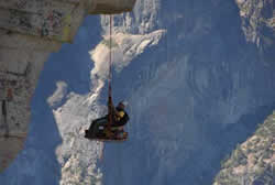
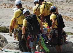
This article as a PDF . The Yosemite Search and Rescue team and Chief Ranger Steve Shackelton of Yosemite National Park were selected to receive a Special Achievement in GIS award this year. GIS has helped the Yosemite Search and Rescue (YOSAR) team improve its methods of operation and has been used successfully in searches for missing persons in Yosemite National Park. Every year, three million visitors come to Yosemite National Park to enjoy the outdoors. One of the nation's greatest travel destinations, Yosemite provides camping, fishing, hiking, and other activities for guests to enjoy. While most visitors have the time of their lives, a few face the frightening prospect of becoming disoriented or getting injured while hiking the park's many trails. Each year, Yosemite National Park responds to hundreds of calls reporting missing persons. Most often, a lost hiker or vacationer is found during the first 24 hours. However, when someone is missing for more than 24 hours, multiple search teams are dispatched. Search and rescue operations require a significant, coordinated effort on the ground and in the air. For these incidents, the National Park Service calls on YOSAR, a team of specialists. YOSAR is a group of park rangers, technical climbers, helicopter pilots, and incident management staff who are directed by Keith Lober, the emergency services coordinator for Yosemite National Park. These skilled search and rescue operators are known around the world for their ability to make backcountry extractions of injured hikers; perform climbing rescues off of "big walls," such as El Capitan; search for missing hikers; and respond to multi-casualty incidents. They work primarily in the park, but are requested by mutual aid management teams throughout the country.
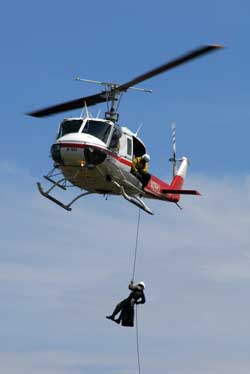
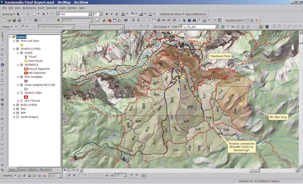
Once activated, YOSAR assembles and deploys ground, technical, canine, and air units and manages the entire incident response process. Managing complex emergency situations requires rapid response capability that ensures a comprehensive, coordinated search is carried out in the fastest possible time frame. Expanding GIS at YosemitePaul Doherty, a park ranger and GIS specialist for the National Park Service, was hired in May 2008 to establish GIS support specifically for search and rescue operations. "Once I settled in and started working, the GIS needs in the Protection Division were evident and the opportunity to get involved was very exciting," said Doherty. The National Park Service has successfully used GIS in its Resource Management and Science Division, as well as in its response to wildland fires. Protection Division chief Steve Shackelton envisions applying the same technology and services to all branches of emergency response (i.e., search and rescue, law enforcement, disaster management, and structural fire) in the park. Managing a Complex OperationMissing person incidents are common in Yosemite. When a hiker is missing or overdue, it requires an initial response known as a "hasty search." These searches are carried out in the first 24 hours in the immediate vicinity where the lost person was last seen. Trail blocks are established to interview possible witnesses and gather information on hiking conditions. If the person is not found quickly, a large search area of 1�40 square miles is drawn on a map. This area is segmented to create smaller search assignments, and a comprehensive search and rescue case is created. Finding a missing person in the wilderness is a complex process. Maps are at the core of this process. Incident managers and field teams want to know the coordinates where the person was last seen to determine where they should begin the search. They also want to know about the surrounding landscape so they can safely and efficiently locate, stabilize, and extract victims as quickly as possible.
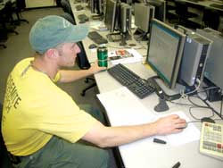
These search and rescue operations, managed under the Incident Command System, can increase in complexity very quickly. YOSAR members are adept at implementing modern search theory as well as using lessons learned from previous searches. In 2008, YOSAR wanted to use GIS to quickly and easily print accurate assignment maps that teams would use in the field. To provide more information about the landscape before teams go into the field, these maps use vector layers and raster imagery. In the past, the mapping component of a search required using hard-copy, outdated 7.5-minute quadrangle (quad) maps, transparent Mylars, erasable markers, and—on occasion—limited mapping software. "It was difficult to keep things organized," said Doherty. "Hard-copy maps and forms are difficult to update and properly archive." Search teams would sketch their assignments on their maps using erasable markers, a process that had the potential to increase error. Because YOSAR staff members were open to innovation, Doherty could implement novel GIS techniques that have changed how YOSAR operates. Maps, Data, and AccountabilityDoherty built a solid GIS platform for preparation, response, and the postevent analysis of rescue operations, employing ArcGIS Desktop (specifically ArcInfo and the ArcGIS 3D Analyst and ArcGIS Network Analyst extensions). The first priority was coordinating existing GIS resources at the park to build databases and processes that could be activated at a moment's notice. With GIS in place at YOSAR, Doherty and staff can now
A myriad of data is built and maintained by the National Park Service and the YOSAR GIS team. This includes vector data for roads, streams, trails, park buildings, vegetation, and helispot locations. Raster data includes digital elevation models (DEMs), which supply a three-dimensional surface with topographic features; digital raster graphics (DRGs), which are high-quality scanned images of U.S. Geological Survey quad maps that provide contour lines and detailed terrain information; and 2005 National Agriculture Imagery Program (NAIP) aerial imagery. During a search incident, Doherty works with YOSAR search incident data to generate additional data such as search area polygons; search segments/assignments; clues (i.e., point last seen, footprints, litter, and trail interviews); viewshed analyses; and GPS tracks from helicopters, ground crews, and dog teams. GIS Gets the Job DoneWith each new search operation carried out by YOSAR since the adoption of GIS in 2008, GIS has become more of a key component.
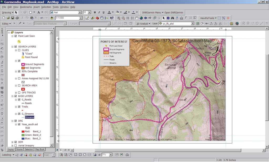
The successful search for Esmin Garmendia illustrates the many uses of GIS by YOSAR. Garmendia, a 23-year-old man who had visited the park with friends, left the parking area and ventured into the woods alone. He was last seen by his friends at about 3:00 p.m. on June 8, 2008. Garmendia's friends returned from their hike, but when he did not appear after some time, he was reported as a missing person. Soon a full YOSAR operation was under way. At a planning meeting, searchers examined where Garmendia was last seen and where he might have gone. DEM, trail, stream, and vegetation data, as well as local knowledge, was used to generate an appropriate search area. The search area was segmented into manageable and clearly identifiable subsections to ensure a new search area would be covered by ground teams, dog teams, and helicopters each day. GIS was used to determine where to place teams in the field. Using the same layers that were used to predict Garmendia's travel, teams were strategically placed to best cover their assigned terrain and ensure that the maximum search area was sufficiently covered. For example, YOSAR used slope data from a DEM of the park to assign technical teams to areas having a slope of more than 45 degrees and dog-assisted ground teams to safer, flatter terrain. In the past, YOSAR staff read the contours on standard quadrangle maps and estimated slope of the terrain. However, with this objective tool for determining slope, decision makers could spend time on other operational, planning, and logistical functions. Next, a briefing was held to communicate search and rescue operation plans to all teams and individuals involved. Incident action plan (IAP) maps were generated to show possible search areas and list objectives. These 8.5" x 11" maps contain metadata such as map scale, title, author, and the date the data was generated. These maps included the point location where Garmendia was last seen; search buffer zones (created using GIS analysis); and topography generated by overlaying DRGs, DEMs, and imagery layers. Search teams were then deployed. GPS and other data was captured in the field and sent back to the incident command post. Updated maps were generated to reflect where resources were sent, how the search was progressing, and what evidence (if any) was collected and where it was found. Previous manual tracking methods using paper maps lacked any type of objective data capture and required scanning to archive the information in a digital format.
Incident briefing maps were used during daily meetings. These paper maps were 24" x 36" and included data from debriefing forms as well as any significant clues from the clue log. The maps showed hazards for new searches in the field, such as cliffs and steep drainages and dense vegetation, and any updates from the previous day's operations. Numerically labeled polygons showed areas that had yet to be searched. These polygons were overlaid with data on trails, rivers, and other physical features. The incident command staff were briefed with maps that showed all areas that were actually searched the previous day and where the new search teams would operate over the next 24 hours. Field teams were provided with new IAPs and 8.5" x 11" assignment maps the next day. These maps included additional information such as declination, a Universal Transverse Mercator (UTM) grid in the correct local datum (North American Datum of 1983), significant landmarks, hazards, and search segment boundaries. GIS helped during all phases of the Garmendia search operation, which encompassed nearly 23 square miles. It helped coordinate more than 190 ground, helicopter, and dog teams. Fortunately for this hiker, Yosemite had a helicopter available for aerial observation throughout the entire operation. After three days of search and rescue operations, a helicopter located Garmendia from the air. He was found safe and healthy, despite his arduous ordeal. GIS provided an information platform to map operations, update information, and improve decision making. GIS methods enhanced YOSAR operations through
"GIS supplies powerful tools, but it will not direct a search," said Doherty. "It does not replace the institutional knowledge of veteran search managers and never will. It does, however, allow us to take advantage of analyses that are far more useful than simple hard-copy maps. It helps us perform a search more efficiently, with enhanced team safety, and with a greater probability of returning victims to their loved ones." Doherty is looking forward to continually expanding the use of GIS in search and rescue during his career with YOSAR and collaborating with incident management teams around the globe who are interested in utilizing GIS. In less than a year, YOSAR's geospatial platform has been used successfully in half a dozen searches. From the peak visitor season in summer to the cold and icy conditions in winter, this platform provides an information-based method for outlining initial search strategies, helps refine the exploration as time progresses, and keeps information continuously flowing from the field to the incident command post and back again. Everyone operates using the same accurate data, which helps find the missing person as quickly as possible. In search and rescue operations, this can mean the difference between life and death. |