GIS Aids Emergency Response

| GIS Aids Emergency Response | |
|
A 25-mile wide thunderstorm stalled over the city of Ft. Collins, Colorado, causing the most extreme weather event in Colorado's recorded history. The 1997 storm dumped 10 inches of rain in 10 hours and turned Spring Creek into a raging torrent. The creek scaled the earthen embankment built to contain it and ripped through an adjacent trailer park and surrounding neighborhoods. The City's GIS department, led by Claudia Haack–Benedict, responded by rapidly mapping the damage and incorporating 30 data layers that included natural habitat, zoning, and public landmarks as well as parcel information. Red Cross workers used the maps for tracking homeless families in need of food and clothing. Buildings with standing water were identified and handled, averting a possible health crisis. The maps produced in the marathon all-night session considerably sped up the work of FEMA teams sent to the City who issued the first relief checks in a just a few days. 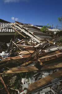
Whether responding to an extreme weather event or manmade hazard, emergency management personnel need the right information displayed in a format that can be rapidly comprehended. Data describing population, physical geography, political boundaries, infrastructure, and other aspects of an area comes from many sources. However the trajectory of most emergency events does not allow managers enough time to gather these resources. Prior to the introduction of GIS, the demands of a rapidly developing emergency often meant that response decisions were based on an individual manager's work experience and intuition rather than current information on the incident. A common GIS-based framework makes data maintained by various agencies readily accessible so that timely information can be brought to bear on the developing situation. This framework also centralizes and organizes data for analysis and visually displays critical information during an emergency. Decisions that direct response efforts require answers to geography-based questions such as Mapping makes complex information instantly comprehensible in a way not possible with text or tables. By giving managers the tools for integrating data from many sources and analyzing how an event will affect an area, GIS is revolutionizing the way governments and other agencies manage emergencies. The development of wireless technologies and Web-based GIS applications have also enhanced the coordination of response efforts. 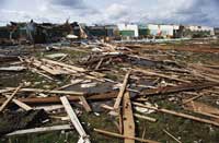
For emergency situations that become disasters, the scalability of GIS is invaluable in coordinating efforts of participating agencies. The difference between an emergency and a disaster is a matter of scope. An unexpected occurrence that endangers people, property, or the environment is an emergency. An emergency that overwhelms the ability of local resources to deal with it is termed a disaster. Although emergencies caused by nature often come most readily to mind, emergencies that result from human actions, whether chemical spills, epidemics, riots, or terrorist attack, are just as much a part of emergency response. The primary responsibility for the public welfare rests with governments at the federal, state, and local levels. However efforts must be coordinated between various government agencies as well as with civil defense agencies and relief organizations. GIS has been adopted for all phases of emergency management--planning, mitigation, preparedness, and recovery--not just response activities. These phases are interrelated and output from one phase is often input for another. Planning involves identifying the hazards, risks, and possible consequences of an emergency. Only after the potential damage of an event is evaluated, can mitigation and preparedness activities start. For example, mapping and analyzing the relations of faults to existing infrastructure highlights areas vulnerable to earthquakes. These areas become the focus of mitigation efforts. In these earthquake-prone areas, mitigation might involve retrofitting existing structures and adopting and enforcing stringent buildings codes for new structures. Local and regional government agencies, realizing the likelihood of earthquakes in an area, can improve preparedness through activities such as stockpiling supplies, mapping evacuation routes, and public education that encourages preemptive actions on the household level. During an earthquake, quickly mobilizing and targeting response efforts will reduce secondary damage from fires, gas leaks, and water supply contamination. Finally, recovery--both short time and long term--can be better orchestrated through GIS. Thorough damage assessment helps in prioritizing repairs. Careful analysis of infrastructure and hazards before rebuilding can create more sustainable communities. Although earthquakes cannot be prevented or predicted with great specificity, these emergency management activities, enhanced through the use of GIS, limit the lost of life and property when earthquakes happen. Public safety applications developed by Esri business partners have exploited the strengths of GIS--data integration, analysis, and dissemination--by incorporating innovative software from Esri. Decision support relies on data from many sources, in many formats. Not only can GIS combine CAD, tabular, and image data with spatial data but it performs that integration dynamically, making it possible to deliver constantly updated information from many sources. E Team, a Web-based emergency and event management software system from eteam.com, inc., uses ArcIMS as the mapping component. This application tracks emergency management resources for large agencies or multiple agencies responding to a disaster, provides incident mapping display on the Internet and/or an Intranet, and has a fully integrated suite of tools that let emergency and event management personnel immediately share critical information. E Team was been used by the City of Los Angeles for handling the Democratic National Convention and will be used for the 2002 Winter Olympics in Salt Lake City, Utah.
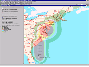
Emergency management programs are developed and implemented through information analysis. Consequence and Assessment Tool Set (CATS), from Esri business partner Science Applications International Corporation (SAIC) demonstrates the powerful analysis possible with GIS. This ArcView GIS-based application provides a comprehensive package of hazard prediction models, casualty and damage assessment tools, and more than 150 databases and map layers describing population and infrastructure characteristics. CATS can be used for in every phase of emergency management and has been used for managing natural disasters such as the 1994 Northridge Earthquake. Not only does GIS improve communications between responders, it can help alert and inform residents of affected areas. Using the GIS interface in GeoNotify, managers can graphically select at risk areas. The application, created by Dialogic Communications Corp. (DCC) and Bradshaw Consulting, automatically contacts each person in the selected area via telephone and delivers a customized message. The application processes GIS-based information at a rate up to 18,000 names/phone numbers per minute and provides immediate notification for HAZMAT incidents, plume dispersions, evacuations, and inclement weather. In an emergency, time can be the deadliest enemy. Hours and even seconds can make the difference between saving or losing lives and property. GIS gives emergency response personnel the tools for data integration, analysis, and communication that can make that critical difference. A new collection of case studies published by Esri Press, Disaster Response–GIS for Public Safety, demonstrates GIS use for many different aspects of emergency management from deciding where to build new fire stations to monitoring disasters in real time. This book is available online at the GIS Store. For additional information on GIS in emergency response, visit the Public Safety pages of the Esri Web site or contact Russ Johnson |