Tracking Diseases with GIS
By Eric R. Conrad

| Tracking Diseases with GIS By Eric R. Conrad | |
|
Editor's Note: In March 2000, the Pennsylvania Department of Health and the Department of Environmental Protection, in cooperation with other state agencies and local governments, finalized plans to monitor the State for potential mosquito and animal carriers of West Nile (WN) virus. This virus causes an infection of the brain. In 1999 an outbreak of this disease killed seven people in New York City. A comprehensive, State-wide plan to detect and respond to a virus outbreak that relies on GIS has been developed by Pennsylvania and is described in this article. Recent reports by the Centers for Disease Control (CDC) and the General Accounting Office (GAO) highlight the need for better federal, state, and local disease reporting. These reports indicate that physicians are unsure when or where to report suspicious cases, are unaware of the need to collect and forward clinical specimens, and may not be educated regarding the criteria used to launch a public health investigation. CDC also reported in 1999 that surveillance for important emerging infectious diseases is not comprehensive in all states. This leaves gaps in the nation's surveillance network and, unfortunately, this situation exists worldwide.
Experts consider rapid and reliable communication between national and international public health agencies essential to an effective response to the threat of infectious disease. Communication of disease conditions between public and animal health communities--including those dealing with domestic animals, wildlife, and other animals such as zoo animals--is very weak and hinders tracking of emerging infectious diseases. The 1999 outbreak of WN virus in New York City highlights the validity of these concerns. Poor communication resulted in the public perceiving government response as chaotic and disjointed. This perception led to criticism that the government was uncaring or incapable of protecting people from the disease or the chemicals used to control the outbreak. In fact, given the resources available, government did a superb job. The real failure was in communicating the problem and how government was handling it. This instance points out the need for better collection of field data, integration of data for decision making, and improved methods for communicating findings and decisions to other agencies and the public. Current systems either do not allow or do not facilitate rapid communication. Information on disease outbreaks is not directly shared between countries, federal agencies, states, nor laboratories, whether on the local, state, or regional level, and the private sector has no vehicle for sharing information with human health or veterinary professionals. Responding to Disease OutbreaksAlthough these concerns have been identified, no organization on a national level has stepped to the forefront with a comprehensive response that provides for an integrated reporting structure, enables timely data collection and assessment, and promotes rapid communication with key organizations and the public. However, the State of Pennsylvania has developed and implemented a system that addresses these issues.
The WNV Tracking System is a spatially driven surveillance program for following and responding to the spread of WNV in the State. The system collects information on the presence of virus in any vector, identifies mosquito-breeding areas, and helps target control efforts. Key innovations include field collection of data using handheld computers and ArcPad software and a Web application that enables data submittal from State laboratories. The system uses Esri software to display data for decision makers and the public. An important feature of the WNV Tracking System is the ID number, a unique preprinted, bar-coded number that is placed on each sample bottle. This ID number is used when entering data into the handheld computer in the field so that all the information about a sample can be kept together in the database. After the field data is uploaded, a quality assurance/quality control (QA/QC) program verifies the accuracy of the data. Only verified data can be added to the central database. When samples arrive at the laboratory, staff electronically scan the ID number from the sample bottle into a Web form designed for the project. Mosquito species are identified, the number of mosquitoes are counted, and this data is added to the database. If the sample is sent to another lab for further testing, the transfer is noted in the database, and final results from any other testing are entered in the database by lab workers using Web forms. Consequently, results are available almost instantly.
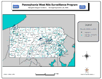
An internal Web server automatically checks the external database and retrieves any new data. E-mails alert decision makers of any new data. Data approved for public release, such as the summary statistics by county, is published on the Pennsylvania's West Nile Virus Surveillance Program Web site. Detailed maps for executive decision making are generated and posted on a secure Web site for review. Expanding Pennsylvania's SystemThis system could easily be converted for use in tracking all infectious diseases. The field data collection, laboratory analysis, and data presentation procedures used for WN virus are similar to those used for a myriad of human, animal, and plant diseases that are tracked by many government agencies around the world and across the United States. Currently, there are more than 50 human diseases that are reported to the CDC. Equine encephalitis, scrapie, avian influenza, Mediterranean fruit fly infestations, plum pox, and Tomato yellow leaf curl virus are just a few of the many reported diseases afflicting plants and animals. The system integrates computer hardware and software with field and laboratory data in a way that has not been done before on a large scale. It proves that handheld computers using Esri software can play a significant role in helping governments respond to disease outbreaks by allowing decision makers to determine if response strategies are having the desired effect. It has been estimated that this system reduces throughput process time by 40 to 50 percent. The use of a system similar to the one used in Pennsylvania shows significant promise for the national, state, and local governments; the World Health Organization; the United Nations; and the private sector. An integrated tracking system, such as one Pennsylvania developed, would enhance a nation's ability to respond to any infectious disease threat, whether natural or intentional. This system enables quick entry of field data, tracking of samples to and between multiple laboratories, conversion of tabular data into information easily understood by professional and lay people, and timely presentation of these results. |