July - September 2003
July - September 2003 |
||||||||
|
|
||||||||
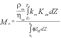
Inherent mobility describes the capability of separate phase hydrocarbon to migrate and is a function of numerous spatial variables. These variables include the soil capillary properties; the soil porosity; the water saturation; the oil saturation thickness, and the density, viscosity; and surface tension of the hydrocarbon. The inherent mobility is quantitatively expressed as in the formula shown in Figure 1. Stability defines the actual movement of the NAPL plume and is the product of inherent mobility and the oil gradient. Due to the complexity and the spatial heterogeneity of the variables defining the hydrocarbon migration, inherent mobility and stability of NAPL plumes at a release site have been difficult to thoroughly characterize using nonspatial methods. A GIS platform is an excellent analysis tool for determining these important conditions at hydrocarbon-impacted sites. By defining the spatial distribution in the properties of the soil, hydrocarbon fluid conditions, oil gradient, and oil saturation volume as layers within a GIS platform, analyses can be performed to evaluate the spatial distribution in hydrocarbon migration.
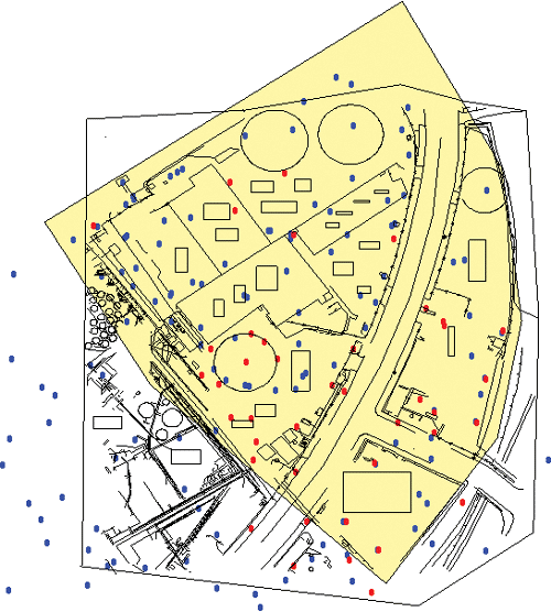
A case study illustrates the applicability of ArcGIS, with the ArcGIS Spatial Analyst extension, to determine the spatial distribution of potential hydrocarbon migration of NAPL at a former petroleum refinery and processing facility where known releases had produced five distinct oil plumes. Site characterization activities at the facility involved the installation of more than 50 soil borings and 35 groundwater wells as shown in Figure 2. Data from these locations indicated that several NAPLs were present at the site, and the plumes varied in composition from fuel oil to diesel fuel. Measured oil thicknesses ranged from less than 0.25 feet to more than 8 feet. In addition, the soils across the site varied from clay to medium sand. To further complicate the situation, the water table at the site varied daily due to tidal fluctuations in an adjacent inlet.
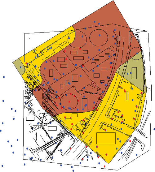
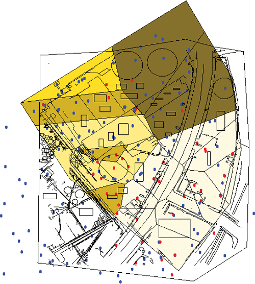
To define the spatially varying complex site conditions, thematic data layers were developed in ArcGIS to define the soil properties as shown in Figure 3 and viscosity distributions as shown in Figure 4. Data layers for product density distributions, free oil saturation distributions, temporally variable water tables, derived gradients from water tables, basemaps, and well locations with relevant attribute data were also developed.
Using these data layers, spatial analyses were performed to determine the inherent NAPL mobility and stability across the site. A grid composed of 699,000, one-square-foot cells was defined across the site. For each cell, the inherent NAPL mobility and stability were calculated using various parameters as defined in the thematic layers. This analysis included surface/raster generations, slope and aspect derivations, reclassification, projection conversions, feature-to-raster conversions, clipping, spatial joins between various thematic datasets, and map and data calculations. Continued on page 2 |