July - September 2005
July - September 2005 |
||||||||
|
|
||||||||
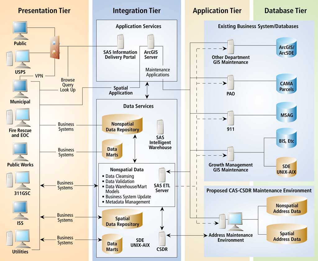
A county needs to improve, modernize, and centralize its address data storage and administration into a single data source. The county's goal is a spatially enabled enterprise address system (EAS) that is automated and standardized. There are two drivers for this project-efficiency and enhanced public safety. Eliminating needless data management and creating a reliable source of address information will make the system more efficient and improve the delivery of services. Eliminating address ambiguity and providing locations to first responders, even when they are dispatched to locations without assigned addresses, will help advance public safety. EAS must deal with complexities caused by the multiple business systems that collect, maintain, and use addresses. These complexities include different classes of addresses, different types and representations of addresses, and the challenge of maintaining data integrity.
Solution EAS architecture consists of presentation, integration, application, and database tiers. It is strategic in nature because it supports and enhances, but does not drive, agency business systems. The central concept of this architecture is found in the integration tier, which will drive management, maintenance, and access to spatial and nonspatial address information. SAS's ETL Server technology helps create a consistent, validated view of nonspatial address data by mediating among various business systems and cleansing, validating, and publishing enhanced data. ArcSDE is the primary technology to maintain, manage, and publish spatial data. Enhanced data can be pushed back into the originating business systems, published into an enterprise repository with a generic data model, or moved to a data mart to meet a specific business need. The integration framework also provides a mechanism for Web and application services. ArcGIS Server technology can provide a set of standard spatial analytics such as location referencing, discovery and extraction, validation, and reporting. Where appropriate, ArcGIS Server can also provide explicit spatial editing tools to support address maintenance. The SAS Information Delivery Portal can provide a public view of spatial and nonspatial address data that is entirely Web based. Constituents, system subscribers, and municipalities can leverage the Information Delivery Portal for validation, reporting, and analytics. This technology also supports data capture to provide a feedback mechanism. Strategic Value Some key strategic aspects of this proposed architecture include abstracted functionality, transparency, augmentation, ubiquity, and Web accessibility.
Case Study 2: Performance ManagementProblem In a large urban county in the Rust Belt in the United States, decreasing funds for operations have affected management and maintenance of the county road system. Road deterioration has been hastened by a lack of good information to support planning, repair, and maintenance. The information systems supporting roads management are old and decentralized, making it difficult for decision makers to triage repairs.
Solution A Road Information Management System (RIMS) project is an enterprise decision support solution. This system automates the full life cycle of road management by taking constituent complaints; creating work orders for repairs; planning for regular maintenance; managing equipment, staff, and inventory; and ensuring that costs are allocated to the appropriate funding source. Key components of this system are shown in the diagram above. Strategic Value The principal outcome of the RIMS project is the development of a system that improves both roads and infrastructure management. The county can establish acceptable levels of performance and, in turn, measure, report, and act upon results. Metrics may include complaint response times, inventory costs, and asset life cycles. This system will enable decision makers to understand how well roads are being managed against budget and work plans and in response to events. RIMS will help the county communicate its efforts, accomplishments, and plans to constituents. Constituent complaints will be tracked from intake to resolution with real-time constituent communication on status and planned resolution date. One of the biggest challenges in road asset management is the allocation of costs against the myriad of federal, state, and local funding sources. This system will enable the use of activity-based costing to optimize reimbursement of county expenses. The analysis and reporting tools available will help the county collect all it is entitled to and find new sources for funding projects. Decision support tools will help the county better understand and optimize allocation of resources to priority projects. Analytical tools will enable the county to perform predicative modeling to understand the useful life of various road surfaces based on traffic patterns and preventive maintenance alternatives. ConclusionThe Fifth Dimension of GIS—spatially enabling business and analytic intelligence—extends existing concepts of enterprise, interoperability, and integration and creates new value for government by leveraging the power of place and analytics in support of fact-based decision making, science, governance, and operation. About the AuthorWilliam S. Holland is a principal, cofounder, and chief executive officer of GeoAnalytics, Inc. He is regarded as an industry expert in the organizational, legal, economic, policy, and administrative aspects of GIS implementation. Prior to cofounding GeoAnalytics, he was the first executive director of the state of Wisconsin Land Information Board and was responsible for implementing the nation's premier program for the coordinated development of integrated geographic and land information systems across local, state, and federal agencies. He is a past president and board member of the National States Geographic Information Council (NSGIC) and provided leadership in its development and formulation of key policy instruments underlying the development of the National Spatial Data Infrastructure. He is currently a member of the National Research Council Committee on Licensing Geographic Data and Services.
|