July - September 2005
July - September 2005 |
||||||||
|
|
||||||||
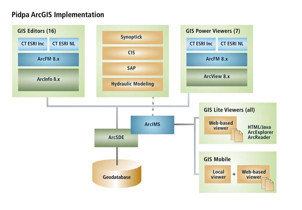
In a utility company, most data has a location attribute so the ability to link detailed data to a location with only a mouse click has many benefits. The ArcGIS and SAP integration implemented by Pidpa demonstrates the value of the integration of business processes in the utility world. Pidpa, one of the largest drinking water companies in the Flanders region, produces and distributes high-quality drinking water throughout the Antwerp province in Belgium. It serves an area of approximately 2,581 square kilometers and continuously provides more than 1.1 million people with drinking water. The company is committed to distributing high-quality drinking water to its customers at an affordable rate. To accomplish this, Pidpa maintains a network of more than 12,000 kilometers of water distribution mains in urban as well as rural areas. Its 26 water production centers annually produce more than 65 million cubic meters of water. The company works with groundwater. Water quality throughout the network is checked by the company laboratory on a daily basis. Water samples from different points in the network are checked to quickly detect any problems. In the event of a problem, its origin can be isolated in the network to minimize the number of customers affected. Pidpa has developed alternate ways for distributing drinking water to affected customers. Small water bags or bottles, created on an emergency production line, are distributed to customers. Water seems like a simple product, but it is actually very complex and requires high standards. Pidpa wants to be the best, not only in water production and treatment but also in water distribution, quality control, customer service, and sustainable management of water resources. IT Strategy: Choosing StandardsPidpa has evolved from a company with many in-house developers and proprietary mainframe-based information systems to a company that uses a standard software approach that can be summarized in one sentence with "buy what you can find and build what you can't find." This approach is based on the typical enterprise resource planning (ERP) business model that stresses the availability of rich generic software, limits the programming required, and shifts efforts to customizing applications to meet company needs. In the long term, this strategy also ensures the company of continuously improving base products due to a large user base. Implementing SAP company-wide is indisputably a cornerstone of Pidpa's corporate IT strategy. The implementation of the ArcGIS family of products from Esri provides a solid GIS foundation that is complemented by the ArcFM solution from Miner & Miner. This database-centric GIS environment for water distribution network management has been operational for more than two years and is still expanding to additional departments. GIS is an important information system at Pidpa. The integration of GIS with other key IT systems provides the organization with new strategic, tactical, and operational opportunities. Information Systems at PidpaInformantion systems at Pidpa include GIS, ERP, CIS, SCADA, and LIMS. Over the last two years, GIS implementation has expanded its focus from GIS editing to making information accessible to a nearly unlimited number of users who can benefit from geoinformation about the water distribution network. An overview of Pidpa's GIS use is shown in Figure 1. SAP is an overall ERP system for the company, and the SAP modules implemented are shown in Figure 2.
All customer information is still maintained in a mainframe-based information system that was developed in-house. It is complemented by an intranet environment that contains day-to-day information and provides a portal to archived information. This allows efficient handling of all customer-related activities. The decision whether to bring this system under the SAP umbrella will be made at a future date. Pidpa has a SCADA system for remotely controlling the function of equipment at water production sites. The SCADA system was developed in-house and stores readings from water towers, pumps, and valves and other necessary information to support decisions and provide necessary input to other parts of the system such as pumps. Pidpa also has a fully equipped laboratory that uses a Labo Information Management System from COMPEX-Unilab to manage all results. What Is GeoLink?GeoLink is a flexible intranet GIS viewer that provides easy access to geographic information for anyone in the company. It was developed and implemented in cooperation with Esri Nederland B.V. and is based on the out-of-the-box ArcIMS 4.1 HTML viewer. The basic viewer layout—with toolbar, table of contents, and a large data frame for optimal viewing—was retained. Standard, powerful GIS functionality was used when possible to limit the need for additional code development in JavaScript and ASP. From the Pidpa intranet home page, a user can start this viewer and access geoinformation. Functionality is very straightforward so there is no need for extensive training. A couple of two-hour demonstrations and good documentation were all that was needed to show users the available functionality. ArcIMS software's central licensing structure is a huge advantage because it limits licensing costs and adds flexibility for the user base of more than 100 viewers. GeoLink accesses data from the central ArcSDE database which is also used by the GIS editors, so GeoLink users always have the most up-to-date GIS data. This environment runs smoothly and doesn't require much maintenance. GeoLink provides the flexibility to tailor the viewer to different types of information. GeoLink Distribution shows all water distribution network data. The same basic structure is also used for a site that focuses on water production and gives users an overview map displaying features such as water production centers, water towers, and pumping stations. In using ArcIMS functionality for viewing company data, Pidpa faced challenges in three areas—symbology, raster data, and printing.
Continued on page 2 |