|
The Magazine for
Esri Software Users |
|
|||
Spatial Analysis of an Ancient Cave SiteBy Holley Moyes, State University of New York at Buffalo
| |||||||||||||||||
| ||||
The Western Belize Regional Cave Project (WBRCP) has conducted investigations at the ancient Mayan cave site of Actun Tunichil Muknal since 1996. GIS is being used as a mapping and analytical tool in the investigation of the cave's Main Chamber, the area most intensively and extensively used by the ancient Maya.
GIS has made it possible to analyze depositional patterns of artifact placement as well as catalog and quantify artifacts. It has provided a well-structured descriptive and analytical tool that has been instrumental in the identification of spatial patterns and will facilitate future regional analysis and intersite comparisons of archaeological data.
GIS has most frequently been employed in archaeological studies for large-scale regional analyses and predictive modeling of settlement patterns and land use. The potential of GIS as a tool for the organization and analysis of spatial data within a single site has hardly been tapped.
About the Project
The WBRCP is directed by one of the authors, Dr. Jaime Awe of the University of New Hampshire. The project is funded by the Social Science and Humanities Research Counsel of Canada. Project work has included the creation of a GIS to investigate the Main Chamber of Actun Tunichil Muknal. This ancient Mayan cave site is located on a tributary of the Roaring Creek River.
| ||||
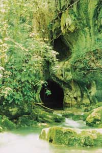
A stream, originating within the cave, runs through its five-kilometer length and culminates at the cave's eastern entrance in a deep green pool. The Main Chamber occupies a high elevation passage above the main tunnel system some 500 meters from the cave entrance. The chamber consists of a series of rooms containing at least 718 artifacts, many of which were broken. Cross-dating of the ceramic assemblage suggests that the chamber was used during the Terminal Classic Period (830-950 C.E.).
Project Goals
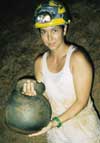
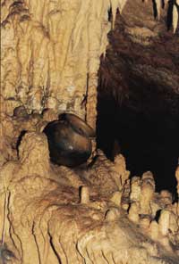
The goals of the project were to record and provenience artifact data, catalog artifact attributes, and analyze deposition patterns. Many of the artifacts in the Main Chamber are cemented to the floor by flowstone (calcium carbonate), which has prevented looters from stealing them and archaeologists from collecting them. This unusual circumstance made the site an ideal location for establishing a natural museum. Because the cave may become a future ecotourist destination, cataloging the artifact assemblage is essential for its conservation and management.
Throughout ancient Mesoamerica caves functioned as ritual spaces-a tradition that has continued to the present day. Many researchers believe that caves were used as a ritual venue to petition gods that controlled the renewal and sustenance of the earth as well as the creation and perpetuation of life itself. Although there is good general understanding of ancient cave use, the nature of the actual rituals that were performed in caves remains a mystery. To complicate matters, archaeologists suspect that there may have been a good deal of variation in use from one cave to another. Isolating these different types of uses starts with a more sophisticated approach to the analysis of each cave.
Viewing Artifacts Two Ways
Since the largest part of the artifact assemblage in Actun Tunichil Muknal consists of sherds (broken pieces) of fairly standard Maya ceramic vessels, it was clear that the usual analysis of artifact attributes would not yield significant insights into the nature of ritual or possible intersite variation in cave use. Artifacts deposited in Actun Tunichil Muknal are assumed to be the remains of ancient rites, direct offerings to deities, or both. By viewing artifact distributions on both local and global scales, researchers hoped that patterns could be discerned in the way artifacts were deposited and associated. These patterns would offer insight into the use of space that could help to determine how the site was used and which rituals were performed.
To meet these goals, the project needed software that could handle large quantities of data as well as create visual displays of that data. Although CAD or DBMS systems organize data and produce images, these systems are not designed to create new data. GIS provided an easily manipulated database, a method for visual display of data, and a tool for the analysis of spatially referenced data-all advantages over other systems considered. In addition, the geographic position and attributes for every artifact in the chamber can be located on a single map that can be viewed globally or in sections.
Using GIS
Field mapping was done using tape and compass. Artifacts were recorded in one-meter square grids that were transferred to the basemap. The paper map was plotted on a scale of 1:60 to enhance detail and accuracy. The map, digitized using ArcInfo, contained morphological features of the cave shown in line and polygon coverages and artifact locations recorded in a point coverage. Artifacts were given discrete eight-digit ID numbers that were coded by artifact class.
The cave's morphological features were divided into seven categories: alcoves, boulders, breakdown, niches, pools, stalagmites/stalactites, and walls and walkways. Each feature category was made into a separate coverage, and these files were imported into ArcView GIS. Attributes were added to the artifact point coverage.
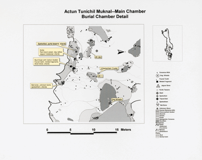
Using this data, a map of the chamber illustrating the cave features and placement of artifacts was produced. The ability to view the site at different scales is one of the major advantages of GIS. Assessments could be made concerning the overall spatial layout of artifacts by globally viewing the cave and its contents. Smaller areas could also be examined so that a more fine-grained analytical approach could be used. Both global and detail maps were easily produced using the ArcView GIS layout function.
| ||||
By using GIS as a management tool, artifacts could not only be quantified but could also easily be reorganized and reassigned into subclasses. The artifact ID numbers simplified this task, allowing rapid production of data tables. By generating shapefiles from the artifacts classes and buffering these shapefiles, the relationships between artifact classes could be determined.
For example, by displaying the data for the locations of all the ceramic bowls in the cave and creating buffers around these artifacts, it was possible to search for correlation between bowls and other artifact classes. The buffer function also made it possible to determine if particular categories of morphological features of the cave were preferred for ritual activities. Buffers for geomorphic feature coverages were created so that counts for the number of artifacts falling within these zones could be generated.
A New Approach to Archaeological Interpretation
Specific aspects of ritual behavior were quantified using GIS. For instance, findings showed that the most common artifact in the cave was a ceramic jar that was traditionally used to hold water. These jars represented 29 percent of the total assemblage of the cave. It was also discovered that 51 percent of all artifacts were located in pools.
The data generated by the GIS was compared with ethnographic and ethnohistoric reports of cave use in the region. Using these sources, a hypothesis was developed that the rituals conducted in the cave pertained to water and may have been conducted to propitiate or honor deities associated with rain or floods. These rituals included both seasonal and calendrical renewal rites. This information has led to additional lines of inquiry and a deeper understanding of cave use.
Conclusion
GIS was instrumental in implementing a new approach to interpreting the archaeological record. This approach combined quantitative and qualitative data. Although this project represents a single site, data generated in this fashion can be compared with data from other cave sites as new databases are created using GIS. This provides concrete units of analyses that may be used in comparing the ritual function of sites both within the region and for areas outside the region.
About the Authors

|
Holley Moyes is an Integrative Graduate Education and Research Training (IGERT) fellow in Mesoamerican archaeology at the State University of New York at Buffalo. The IGERT program, sponsored by the National Science Foundation, awards a fellowship for cross-disciplinary study of GIS. Moyes' graduate work is in speleoarchaeology and the study of ancient Mayan religion.
Dr. Jaime J. Awe is an assistant professor of archaeology at the University of New Hampshire and director of the Western Belize Regional Cave Project. He is a native Belizean and serves as the director of the Belize Department of Archaeology.
All photos courtesy of Holley Moyes
Resources
For more information on this please contact Holley Moyes or Dr. Jaime Awe.


