|
The Magazine for
Esri Software Users |
|
|||
Targeting the Source of Illegal GunfireBy Tony Bradshaw, Bradshaw Consulting Services, Inc.Editor's Note: The rise of illegal gun use and related crimes threatens the safety of communities in the United States. These crimes not only endanger residents but also impact them economically as taxpayers end up shouldering the majority of gunshot-related medical costs. The largest sheriff's department in the world, Los Angeles County Sheriff's Department (LASD), is using a GIS-based tool to combat illegal gun use. This system, comprised of the Shotspotter and The Communicator! applications, was inducted into Smithsonian Institute's National Museum of American History as part of the 2000 Information Technology Innovation Collection. The collection represents the year's most innovative applications of technology. In a pilot program launched in the Willowbrook area of Los Angeles County, the LASD is using a gunshot location and notification system that gives officers better crime information, identifies hot spot areas, and assists in community outreach. Stretching across 4,083 square miles and encompassing 88 cities and many small communities, Los Angeles County is home to 9.8 million residents. The Willowbrook area of Los Angeles has been plagued with drive-by shootings, gang violence, and drug-related crime. Residents, who have grown complacent or fear retaliation from offenders, have developed a "see, hear, and tell nothing" attitude toward gunfire. Deputy Thomas Fortier of the LASD estimates only 20 percent of the area's gunshots are reported.
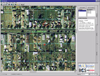
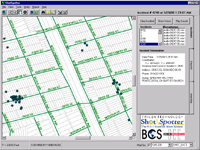
GIS and Gunshot DetectionIn late 1998, Trilon Technologies LLC, Dialogic Communications Corporation (DCC), and Esri business partner Bradshaw Consulting Services, Inc. (BCS), developed a system that detects gunfire activity and provides information to help police respond more safely and effectively to these incidents. The system was first adopted by the Redwood City Police and the San Mateo County Sheriff's departments in California. The interface to this system, designed by Bradshaw Consulting Services, uses MapObjects 2 GIS and mapping components to locate the source of illegal gunfire. The interface, called ShotSpotter, displays an aerial photograph of the area overlaid with streets, parcels, and other features. Imagery is used in the MrSID format developed by Esri business partner LizardTech. The MrSID aerial image allows the police to see details of an area. Incidence ResponsePrior to dispatching an officer to the scene, a trained dispatcher listens to the recordings of the event and determines what the sound was and if it warrants mobilization of police forces. The system quickly identifies the incident location and generates information on its address, the owner's name, and the telephone number for the nearest address. This information is relayed to officers so that they can effectively pursue suspects and gather information. The dispatcher can also graphically and interactively select an area surrounding the shot and immediately see a list of all homes and businesses within the area. The system can extract contact information for residents within a defined proximity of an event at the rate of 30,000 names and addresses per minute. Using The Communicator!, the dispatcher can automatically initiate a call to all of the homes and businesses in the area. A recorded voice identifies the call as coming from the police department and asks a series of questions relating to safety of the residents and asking if they need assistance. The homeowner responds to each question by pressing a button on the phone. The response is automatically recorded and a printout is created at the dispatcher's office. This gives police a list of witnesses to interview without wasting time knocking on doors.
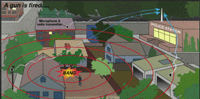
System ConfigurationThe ShotSpotter system relies on a series of six to 10 specially designed acoustic sensors strategically placed in each square mile of a problem area. These sensors, located on rooftops or utility poles, are networked via telephone or radio to a central computer at the dispatch center. The application runs on Windows NT operating system. Gunshot fire, picked up by the microphones, is transmitted to the server at the dispatch center. The system requires that at least four microphones register the event before it analyzes the recordings. The difference in the time it takes for the sound of gunfire to reach each microphone is used to triangulate the location of the shooter. Sound travels at about 1,000 feet per second, so in a millisecond gunshot sounds will have traveled about one foot. Within 10 seconds of the event, the terminal in the police dispatch office sounds an alarm and shows the location of the shot on a map. Quick Response and Valuable InsightsThe combination of ShotSpotter acoustic monitoring, GIS mapping, and database system and automated notification capabilities provides the police with an effective weapon for reducing and perhaps eliminating gunfire in a monitored area. GIS improves communications by providing the LASD with a single, automated source for geographically identifying the residents to be notified and extracting contact information. Messages are launched to multiple recipients--from a small group to thousands--within a short period of time. GIS also enables dispatchers to prioritize the order of calls made by proximity to the incident.
The system's mapping capabilities enable LASD to gather accurate and timely intelligence for crime analysis and future planning. Geographic data is used to provide officers with current data for investigations, identify hot spots, track activity and trends, and forecast and plan deployment of response teams and resources. The ability to accurately identify the location of the gun also enhances the chances of locating spent cartridges from the bullets fired. Spent cartridges, uniquely marked by the firing pin in the gun, can be matched with fingerprint-like accuracy to the specific gun that fired the bullet. "GIS technology enables us to quickly zero in on an event and its location with greater precision, giving our officers increased lead time for response," says Lt. Sid Heal of the LASD. "That stacks the odds against offenders, which can translate to improved community safety." About the AuthorTony Bradshaw is a programmer specializing in GIS, database development, and Windows NT-based network systems. He acquired extensive experience designing and implementing technical applications while working as a contractor for the Department of Energy. He has developed applications using Visual Basic, Visual FoxPro, SQL Server, and MapObjects. He and his wife, Elizabeth, founded BCS and have established for the company a solid reputation as both a GIS reseller and application developer. ResourcesFor more information on ShotSpotter, contact To learn about other law enforcement applications that use GIS, visit the Esri Law Enforcement pages. | |||||||||||||||