Decision Support for Multimodal
Freight Transportation
By John Sutton and Kenneth Bennett, GIS/Trans, Ltd.

| Decision Support for Multimodal By John Sutton and Kenneth Bennett, GIS/Trans, Ltd. | |
|
The challenge for those planning transportation networks in this area is to develop transportation corridors while balancing environmental constraints. Conventional approaches using transportation models only focus on network components and fail to adequately address broader environmental and economic impacts. A more integrated and comprehensive decision support system is required. The Inter American Development Bank (IDB), sponsor of many infrastructure projects in South America, turned to GIS to provide a solution.
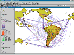
The MERCOSUR region of South America is a trade zone similar to the one created in North America by NAFTA. While NAFTA has been successful in promoting cross-border trade and trilateral economic development, the MERCOSUR economies have not converged as well as hoped, due in part to difficulties in transportation and communication. The Andes mountain chain makes east–west communications across the region difficult. Poor transportation links hamper freight movement. Bottlenecks occur on congested roads, railways, and at transshipment points. Freight can be delayed for days, adding cost and introducing unreliability to delivery schedules. Although improved transportation infrastructure is recognized as a key requirement for economic growth and social development in South America, environmentally sensitive areas, such as the pristine rain forest in northern Bolivia and the wetlands of southwestern Brazil, must be protected also. A decision support system differs from a traditional planning model; it does not attempt to provide a single, optimized output based on inputs and the modeling system. The GIS-based Decision Support System (GDSS) developed for the IDB analyzes different scenarios, tests different inputs under various modeling parameters, and displays results on digital maps. Thus, the modeling component per se is simpler, more flexible, and can analyze many different types of data. The GDSS is a prefeasibility planning tool that eliminates projects with significant environmental impacts or projects that are unlikely to meet transportation goals. This filtering process selects alternatives that can then be analyzed further using more deterministic models and methods. How Does It Work? The GDSS is composed of various applications including a GIS-based Planning Information System (GPIS), GDSS, the Spatial Data Browser (SDB), the Project Management Information System (PMIS), the Integrated Planning Support System (IPSS), and a Microsoft Access database. The GPIS component, developed using ArcView GIS 3.2, contains functionality that supports transportation planning activities. Users can display spatial data layers containing various types of information used in the transportation planning process such as transportation networks and supporting infrastructure, political-administrative areas, and environmental and physiographic data. It employs a Linear Referencing System (LRS), which is supported by a route system (a measured shapefile) that models the national transportation infrastructure. This route system displays alphanumeric transportation planning data that is referenced to the route system and its linear measures (i.e., this data has been added as an event theme) in the GIS. Examples of these types of data are road characteristics maintained in the highway inventory, traffic accidents, and transportation projects. GPIS performs geographic analysis of the data and prints maps. Attribute information about all of the layers used by the GPIS is stored in a central Access database. The GDSS component, also developed in ArcView GIS 3.2, analyzes and plans freight flows on corridors that connect countries in the MERCOSUR region, other associated countries, and Peru using a simple multimodal transportation model. The supply and demand for international cargo data used by the model is reflected in an origin-destination (O-D) matrix and a network of alternative transport modes used to display cargo flows. The model generates the cargo flows by calculating the least-cost path between each supply-demand pair of nodes using the ArcView Network Analyst extension and then making unconstrained traffic assignments across those paths. The objective is to minimize the total transportation cost on the network. The model results are passed to a tool provided by the GDSS for analyzing the costs and benefits of transportation projects. The GDSS can also be used for conducting spatial analysis of the environmental impact of proposed transportation projects. The GDSS models cargo flows on roads, railways, and rivers inside South America and on sea lanes to zones in other continents. It can integrate international trade flows in addition to flows between MERCOSUR countries. The multimodal network consists of links that represent the four transportation modes, as well as links that represent intermodal transfer points and connectors to the various zones. Impedance values for each link in the network are stored in cost-per-ton units. The GDSS not only enables user-defined default impedance values (e.g., based on user surveys or published records) to be applied across the entire network, but also provides a GUI-based mechanism for customizing the cost across an individual link. The assignment of O-D flows is generated using Premium Solver Plus by Frontline Systems, a linear programming solver that is an add-in to Microsoft Excel. The flows can be generated for as many as four different commodity types and analyzed by commodity type, all goods, origin, destination, or O-D pair. The costs and benefits of transportation projects can be analyzed by performing multiple runs of the model, with or without transportation improvements. Each run of the model is stored as a separate scenario that includes the geometry and attributes of the multimodal network. With this approach, edits can be made to the network geometry or the network attributes (such as adding a new transportation corridor or widening an existing route), as well as to the O-D matrix. From network building to network assignment, each scenario run takes approximately 40 minutes to complete, so it is possible to perform several scenario tests in a day. Transportation project data is managed in PMIS. This application was developed in Visual Basic and enables a distributed group of project managers to input, update, and query information about projects stored in the Access database. These projects can be displayed as events on the route system within GPIS or used to generate scenarios in GDSS. Data and Linkages The base map and transportation data were compiled by IDB and a team of contractors led by GAF Gmbh of Germany. GIS/Trans, Ltd., developed the GDSS application and the algorithms that perform modeling inside ArcView GIS and Excel. Although official data for establishing the transportation costs for different transportation modes was scarce, this data can be added easily to the model once it becomes available. Disparate data sources are integrated in ArcView GIS and used to create a comprehensive system for regional transportation modeling. Transportation planners in Bolivia and Chile have received training and are updating the GDSS with their own data. This will improve the accuracy and acceptability of the model results in these countries. The application also has been specified by the IDB for use with other infrastructure planning projects in Peru, Brazil, and Uruguay. GDSS links to other applications that can provide input or can use output from the model. A simple interface developed in Visual Basic launches all the components of GDSS, other applications used by government agencies, and planning models. It provides flexible access to the applications, the metadata for the spatial data, and the system documentation. GIS and Transportation Planning The GDSS application demonstrates the capability of GIS to support regional transportation planning and modeling activities. Specifically, the GDSS approach lets planners evaluate projects and test "what-if" scenarios quickly and effectively and gauge the likely benefits and costs of a project. In countries where transportation data is scarce and resources for planning are limited, this is a highly beneficial tool.
Spatially integrating data in a common format creates a uniform platform to display, query, model, and evaluate transportation flows and plan projects. Centralizing data in an Access database permits updating spatial data attributes and highway event data from a single administrative location, and the database is a repository for all transportation project information. This decision support system, which can be supplied quickly to users of desktop computers, provides a common framework for integrating transportation planning information and assessing the feasibility of projects prior to a full-scale study. For more information on this project, contact About the Authors Dr. John Sutton, president of GIS/Trans, Ltd., is a recognized expert in integrating GIS and transportation data. For more than 10 years he has researched and applied GIS in transportation planning. He holds a bachelor's degree in environmental sciences from the University of East Anglia in the United Kingdom and a doctorate in transportation planning from Nottingham Trent University, also in the United Kingdom. Kenneth Bennett is a senior analyst at the GIS/Trans, Ltd., office in Southern California. Fluent in spoken and written Spanish, he was the lead programmer in developing the GDSS application. He holds a bachelor's degree from the University of California, Los Angeles, and a master's degree in GIS from the University of Tennessee. |