Dark, Wet, Muddy Places Led to GIS

| Dark, Wet, Muddy Places Led to GIS | |
|
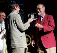
During the plenary session of the 2001 21st Annual Esri International User Conference, Esri President Jack Dangermond introduced Dr. Michael F. Goodchild as, "Not only a dear friend, but a person who has touched all of us." Joining Dangermond in presenting Goodchild with the Lifetime Achievement in GIS award was Dr. Roger Tomlinson, the recipient of the first Lifetime Achievement in GIS award who is acknowledged as the "father of GIS."
In presenting the award, Tomlinson lauded Goodchild as the foremost GIS scholar and the person who has "put GIS science in place as a subject for teaching at university level and beyond." Goodchild is a professor of geography at the University of California, Santa Barbara; chair of the executive committee for the National Center for Geographic Information and Analysis (NCGIA); director of NCGIA's Varenius project; and associate director of the Alexandria Digital Library Project. In addition to authoring more than 300 scientific papers, he has served on editorial boards for journals and books. His achievements have been recognized with many other awards including the Canadian Association of Geographers Award for Scholarly Distinction, the Association of American Geographers Award for Outstanding Scholarship, the American Society of Photogrammetry and Remote Sensing Intergraph Award, and the Horwood Critique Prize of the Urban and Regional Information Systems Association. While Goodchild said he was both flattered and honored by the award from Esri, he also confessed to being a little daunted to receive an award for lifetime achievement. In his acceptance speech, Goodchild focused on personal rather than professional aspects of his interest in geography and GIS. While growing up in south Devon, England, in an area with limestone formations, he took up caving. He was drawn by the beauty of caves and the physical and mental challenges of exploring them.
Goodchild also touched on a couple of his other passions. He is concerned about promoting geographic education and mitigating geographic ignorance. "I can't believe people would choose aisle seats in an airplane when they can sit in a window seat and look out over the planet," he said. He believes that exploring this "interesting and complex planet" is vitally important, and it would be a tragedy if GIS caused people to spend more time in offices in front of computers and less time in the field in touch with geographic reality. He hopes that wearable computers and other portable technologies will help redress this situation. Finally, he talked about his passion for data accuracy. "The quality of data that we work with in our GISs is one of the most important factors. It means a great deal to produce results that are accurate and certain as compared to results that are inaccurate and uncertain." |