October - December 2002
October - December 2002 |
||||||||
|
|
||||||||
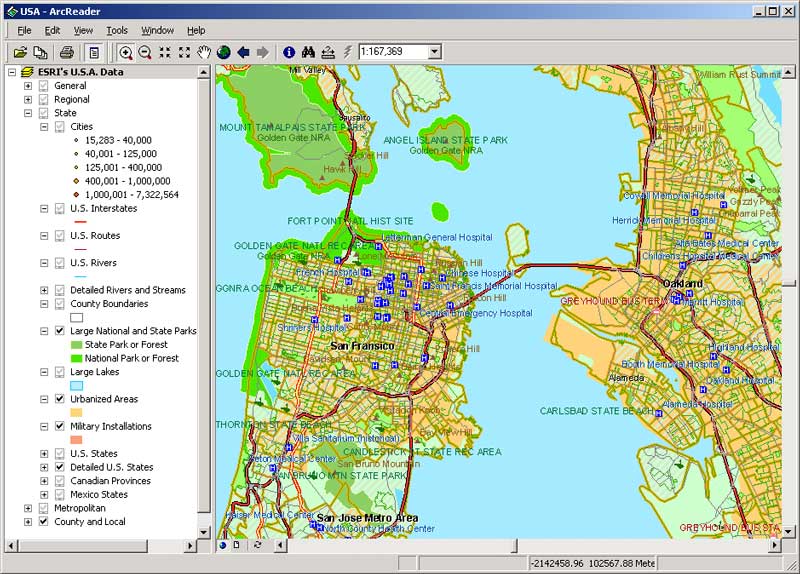
Interactive maps are nothing new to GIS users. More than a pretty picture, interactive maps have two advantages over traditional paper maps-access to the most up-to-date information and specialized tools for retrieving information. Interactive maps provide new opportunities for distributing information within an organization or to the public via the Internet. Traditionally, only highly trained professionals could leverage information from GIS. Those unfamiliar with GIS depended on these GIS professionals to meet all their spatial analysis and map-making needs. Now maps generated using the ArcGIS Publisher extension can be read by anyone with ArcReader, a free reader for map documents, or via the Internet using a browser to access an ArcIMS-enabled Web site that has implemented ArcMap Server. Using either of these strategies, GIS departments can provide managers and customers with interactive maps that access spatial information easily and efficiently. This article describes how to share interactive maps of high cartographic quality using the ArcGIS Publisher extension and/or the ArcIMS ArcMap extension. Sharing Interactive Maps vs. Plotted Paper MapsInteractive maps can reach a wide variety of people at a very low cost and can be modified to reflect changing business requirements and objectives. With interactive maps, organizations can update centralized databases independently of the map. For example, the street centerline database used to provide driving directions at a Web site can be updated monthly as road construction is completed. The updates are transparent to visitors using the Web site because the map is independent of the data. Though this concept is not new, two recently released GIS software programs--ArcGIS Publisher and ArcIMS ArcMap Server--can be used to achieve this goal. The ArcGIS Publisher extension and the ArcIMS ArcMap Server extension both allow users to print and analyze data without having to rely on GIS department personnel. Users can export a map file for publication purposes or a hard-copy plot that can be included with a report or proposal. When using paper maps, complex analysis can require several paper maps. Only one interactive map, accessing one or more data sources seamlessly, is needed to deliver the same information. Unlike paper maps, digital maps can link database features to supporting documents. For example, a sewer network feature can be linked to maintenance videos or the location of a business on a map in a kiosk application can be linked to that company's Web site. None of this is news to GIS users but for engineers or managers not familiar with GIS, ArcReader or a Web site using ArcMap Server can supply spatial information inexpensively and easily. And in situations for which paper maps are still the best solution, maps can easily be printed using ArcReader or a Web browser. Specifying Functionality and Format With ArcGIS PublisherThe ArcGIS Publisher extension allows users to convert ArcMap map documents (MXD files) to print published map files (PMF), a new document format. This new read-only format can be opened using ArcReader, served to a browser using the ArcIMS ArcMap Server extension, or opened in ArcMap. Any layers present in the original ArcMap document-rasters, geodatabases, shapefiles, coverages, CAD data, and ArcIMS map services-can be published to this document. PMF files don't incorporate data but link to it. Map publishers can specify which layers will be published, whether data view and/or layout view will be displayed, and what functionality (navigation, printing, querying) will be available when viewing the document in ArcReader. For example, if panning and zooming capabilities are the only functionality requirements for users, the identify tool can be disabled to protect confidentiality of the data. Documents can also be password protected to limit assess to data. Spatial bookmarks can be published in the document so users can efficiently locate what they need. Viewing, Querying, Printing With ArcReaderArcReader is a free, lightweight application for viewing map documents created in ArcMap and published using the ArcGIS Publisher extension. While ArcExplorer, also available at no cost from Esri, is a GIS data reader, ArcReader allows users to view and interact with PMF format files. PMFs retain the same look and feel as ArcMap documents and can use the same data sources and layer formats so data from different databases and map services, whether accessed over the Internet or locally, can be presented seamlessly in a single map document. A PMF document preserves the layout created in ArcMap and supplies the same cartographic quality for map output. PMF maps can be cut and pasted into applications such as Microsoft Word, printed to a file, or plotted to any size supported by ArcMap and specified during publication. Depending on the functionality specified when the PMF was created, ArcReader users can use pan, zoom, identify, measure, hyperlink, and find tools for navigation and simple queries. Bookmarks created during publishing can direct users to areas of interest. The identify tool also can sort results and copy/paste items to other, non-GIS applications. Publishing maps using the ArcGIS Publisher extension provides a low-cost option for distributing maps that does not require GIS knowledge on the part of end users and can be ideal for distributing data to decision makers. It can be used to create portfolios of data and maps on a CD-ROM for distribution. High-quality maps can be distributed and printed and lightweight PMF documents can be e-mailed. The use of many copies of ArcReader for nonGIS staff can lower administration costs while providing access to centrally maintained data. Generating a digital rather than a paper map archive can save space and make resources more readily available. Using ArcMap Server With ArcIMS
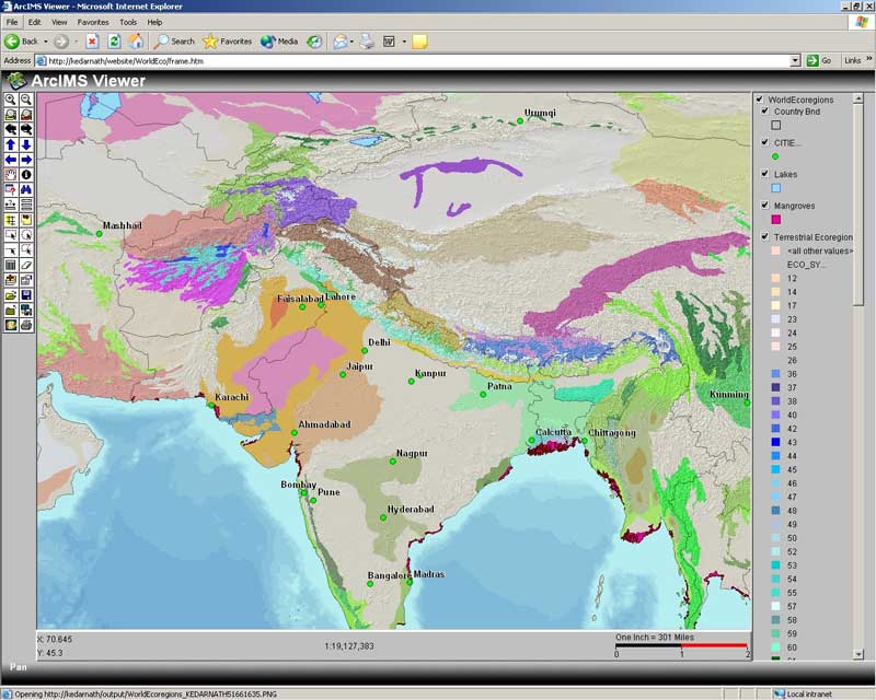
ArcIMS enables organizations to deliver interactive maps over the Internet using image or feature services. The ArcMap Server extension, part of the core ArcIMS product at version 4, adds a new ArcIMS service that allows distribution of maps created in ArcGIS ArcMap without re-creating symbology or layout. It supplies the advanced cartographic options available in ArcGIS ArcMap, such as complex symbology and scale-dependent rendering, without have ArcMap running in the background. The ArcMap Server extension makes printer-friendly online maps easy and supports multiple output formats-JPG, PNG, PDF, EPS, EMF, and AI (Adobe Illustrator). In addition to making the robust cartographic capabilities of ArcMap available, ArcMap Server also adds data sources, such as CAD, annotation, and VPF layers, and makes data from versioned databases and network data (i.e., dynamic segmentation layers) available. It can also serve PMF files. ArcIMS ArcMap Server works with any ArcIMS client that can access ArcIMS image services including browser-based clients, ArcExplorer, and ArcGIS Desktop products. Using the Right Tools for Your SituationDeciding whether to use the ArcGIS Publisher/ArcReader approach or an ArcIMS ArcMap Server Solution depends on your current GIS implementation and your functionality requirements for shared maps. Using ArcGIS Publisher might work well for an organization that currently has ArcGIS but not ArcIMS and needs to make maps accessible to nonGIS staff within the organization. For data that does not require frequent updates, distributing PMF files with data on a CD-ROM may be a good solution. In either case, this approach requires only the purchase of a single extension license. ArcReader has no associated cost and requires little to no training for users. The ArcGIS Publisher extension and ArcReader run on Windows NT/2000 and XP. ArcIMS ArcMap Server enhances the operations of an organization already using ArcIMS to make geographic data available. It delivers a wider variety of functionality through its customization capabilities, enabling users to make more advanced spatial queries. ArcIMS ArcMap Server runs on all supported ArcIMS platforms. Although there is some overlap of functionality, particularly in Intranet environments, organizations may find that both approaches can be used to meet different interactive mapping needs. Sharing interactive maps gives organizations new ways to distribute geographic data whether accessed using ArcReader on the desktop or over the Internet using a browser. The ArcGIS Publisher extension and ArcIMS ArcMap Server extension provide two methods for producing interactive maps with high cartographic quality that can viewed, queried, and printed. For more information, visit http://www.esri.com/software/arcgis/ arcgisxtensions/publisher/ and http://www.esri.com/software/ arcims/. Additional information is also available from the online help for ArcMap under ArcMap > Creating maps > Creating interactive maps. |