The AMD is loaded into ArcView on start-up and held in memory throughout the ArcView PLAT session to facilitate rapid access to the business object properties. Every PLAT request is sent to AMD. AMD interprets and translates the request before handing it off to Fetcher, a customized routine that retrieves the spatial and attribute information. The current AMD is an XML formatted file, so the users can configure the business logic by updating AMD in a user-friendly XML Editor. No changes to the source code are necessary to update the data source, data definition, or business logic.
Fetcher, PLAT's custom query engine, returns each spatial query on an SDE-based layer as a shapefile snapshot using the SDE C-API to retrieve spatial geometry and attributes from databases and convert them to shapefiles and/or ArcView tables on the fly. Custom-built for Burlington Resources, Fetcher enhances the performance and functionality of SDE data retrieval from databases such as the DataMart.
DataMart is an intermediate Oracle database that holds much of the data used by PLAT that contains the Oracle tables and SDE layers that are the source for most of the business objects. The attributes of the business objects are pulled from these external databases and combines spatial and attribute data into one logical database. To ensure that the DataMart tables are kept up to date, it is updated on a regular basis using data extracted from other Burlington databases. DataMart is the main data source for PLAT business objects.
The system provides six major functions: Area of Interest, Query, Analysis, Imagery Management, Data Exchange, and Automated Mapping.
Area of Interest--The user can spatially define a study area by creating an Area of Interest (AOI). Saved AOIs are recorded by the system so the user can navigate quickly to a geographic region. AOIs preserve place name, projection, coordinate system, scale, and user information. Users generate collections of AOIs and can use them to spatially filter query and analysis functions. AOIs can also be saved to a floppy disk or network drive for sharing. Currently, PLAT offers a custom interface for a variety of creation methods:
- Current viewing window.
- User-defined county, township/range, and/or section.
- Drawing an area on the screen with the mouse.
- AOI based on selected features in the view.
- AOI based on selected graphics in the view.
- Input latitude and longitude coordinates.
- Input projected coordinate system units.
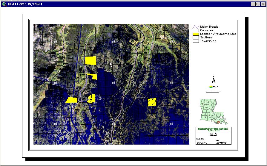
Query--Leases with payments due, expiring leases, and well depths are examples of the type of custom queries that can be executed. PLAT provides an interface that allows users to create simple and complex queries without having to know underlying database details. PLAT presents business logic as plain English through a custom query interface, and translates a user-defined query into a database-specific query language such as Structured Query Language (SQL) or native ArcView syntax.
In addition, an Area of Interest can be applied to any query to restrict the results to a specific geographic region. Once a query is created, it can be saved and run at any time during a PLAT session. Similar to saved AOIs, queries can also be shared between PLAT users. Complex queries that require multiple table joins or access to Oracle views are performed on the fly without the user's knowledge. This functionality makes Query a powerful tool that is easy to use.
Analysis--Several analytical functions have been implemented in PLAT, including Drilling Unit Analysis and Stacked Polygon Analysis. Analytical functions are managed the same way a query is managed. A custom interface that supplies database values (i.e., formation groups and formations) helps the users create an analysis function. The analysis is saved and can be executed at any time. Applying an AOI filter, the output includes only results located in a specific area. Like saved AOIs and queries, PLAT analysis functions can be written to disk and shared between PLAT users. Output from running analyses is automatically added to an ArcView session as a shapefile and associated tables, and a report is written to either a spreadsheet or Web browser in formatted HTML.