GIS to the Rescue
Continued...
Despite the best efforts of responders, rescues do not always have happy outcomes and, unfortunately, Meyer has had drowned victims, including some children. "When the opportunity came that I could utilize my knowledge of GIS, coupled to sea rescue and EMT work, I decided to write a sea rescue application that will enable someone to track, control, or estimate where a victim may be," said Meyer.
With 12 years of experience with Esri software in addition to his knowledge of sea rescue, Meyer realized that GIS could supply an intuitive tool for visualizing these types of emergency situations and coordinating aid efforts. When he began designing RescueView, he found an abundance of GIS-based emergency applications but few that dealt with sea rescue.
Writing an application for volunteers who would never have time to become GIS experts applied an additional development constraint. NSRI's limited funds affected the hardware which, in turn, affected the choice of GIS software. An earlier agencywide requirement for electronically filing event reports had meant that all stations did have computers but these machines were not necessarily the newest or most robust. Installing computers onboard was not an option as the rescue craft are open boats and funds for ruggedized devices of any type were not available. What Meyer needed was an application that was simple and inexpensive and easy to operate for nonspecialists.
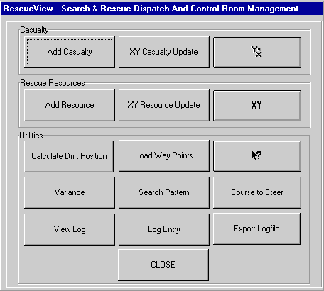
The result, initially developed in about two weeks, presents users with a pared down interface. All the buttons for RescueView functions are logically grouped and presented in a main dialog box. When an incident is called in, a station staff member creates an operation. To this operation, he adds what is currently known about the event such as a description of the victim, the victim's last known location, and the status of any responding units. Once entered, this information is automatically symbolized in the view.
The staff member will continue updating the operation log throughout the incident as new information becomes available. The log file can be viewed but not modified. Originally just a text file, the log file was converted to an INFO database so that it could be categorized and searched and it has playback capability. The log file is both a useful diagnostic tool for debriefing and a legal safeguard should rescuers be called to testify in court.
If, in their haste to respond to the incident, rescuers cannot take time to supply GPS-generated coordinates, station staff supply approximate coordinates from a known places database or by querying the view. Coordinate information can be manually entered or can be imported as way points that have been captured by a GPS unit.
Calculations made by RescueView take the effects of variance and deviation into consideration. Variance is the magnetic displacement from true North localized for the immediate area. Deviation is the effect on the compass needle of components in the boat such as magnets or metal objects.
 |
| All the buttons for RescueView functions are logically grouped in a main dialog box. |
The Drift Locator, the most important enhancement to come out of the Table Bay experience, calculates the current position of the victim based on the last known position and drift information gathered by rescuers. Drift is determined by putting a swimmer into the water and noting the start and end coordinates and time. The Drift Locator extrapolates the victim's position. Course to Steer functionality uses information from the Drift Locator to plot a course that helps rescuers travel directly to the casualty.
Search Pattern functionality supplies coordinates for standard search patterns so that rescuers can systematically work a sector and know which areas have been covered. The search routes for each boat can be displayed on-screen.
Standard 1:50,000-scale topographic maps of the area that were scanned and georeferenced are used as a backdrop. These maps were chosen because nautical charts are available only at a much less useful scale, 1:250,000, and do not supply the kind of detail needed by rescuers. Lacking a readily available street network, the topographic maps also supply street information. The scanned maps have been augmented with a known place names database that contains coordinates.
Before RescueView was developed, the staff back at the station control room never knew what was going on and could not coordinate resources. In a major event, control staff could not keep the media apprised of the situation. With RescueView, station staff not only are aware of the current status of any rescue, they can actively assist.
RescueView, currently developed as a project, will be distributed as an ArcView extension after it has been exhaustively tested and further refined. Esri donated 27 copies of ArcView so that RescueView can be installed at all NSRI stations in time for South Africa's 2002 summer season.
For more information, contact Kobus Meyer at kobus_meyer@esri.com.
|