Sharing and Building Relationships
"Why are we here? Why are you here?�If I could boil it down to one word, it's about sharing and building relationships," said Esri President Jack Dangermond during his opening day address to most of the more than 11,000 attendees of the 22nd Annual Esri International User Conference.
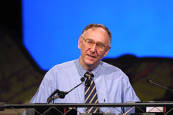 |
| Esri President Jack Dangermond |
This conference, which remains the largest of its kind in the world, drew users from 135 countries around the world to San Diego, California, to share information and ideas. While celebrating the conference as an opportunity to build relationships with other GIS professionals, Dangermond urged his listeners to consider their relationship with the natural world.
He described the earth as "an oasis in the universe" that provides everything needed for life. However the human population is having an increasingly adverse effect on this oasis. Demands on the earth's finite resources--caused by population growth, urbanization, and pollution--are straining the planet's resources beyond its ability to recover. He cited a report by the United States National Academy of Sciences that estimates that economic expansion has overshot the earth's ability to regenerate natural resources by about 20 percent.
Dangermond encouraged conference attendees to work toward a more equitable relationship with the natural world. "Sustainable development means living within the regenerative capabilities of the biosphere, meeting our present needs without compromising the future."
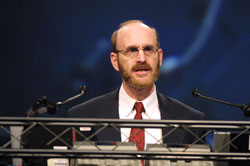 |
| Al Leidner, director of citywide GIS, New York City Department of Information Technology and Telecommunications, received the President's Award for his work reconstructing a complete GIS within days after the September 11 tragedy. |
As GIS professionals involved in developing and implementing the spatial data infrastructure, he observed that the audience has a special role in this important work. GIS has evolved from a technology focused on specific projects to a framework for monitoring conditions and organizing human activities that can be integrated across the Internet to create something that could be called a "digital earth."
With the development of faster computers, small mobile wireless devices, and advances in interoperability, Esri has created GIS solutions, such as ArcIMS, ArcPad, and now GIS Web Services, that take advantage of this new distributed environment and make data gathering and dissemination more efficient and accurate. Data models that are being developed for individual industries and applications provide templates for modeling and capturing the behavior of real-world objects in a geodatabase.
Dangermond concluded his remarks by saying, "By working together the GIS community can make a significant contribution to the development of a sustainable future. With our spirit of collaboration, we can make a difference."
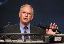 |
| Gilbert Grosvenor, chairman of the board of the National Geographic Society, was honored with a Lifetime Achievement Award. |
The keynote speaker, Cynthia Moss, has spent more than three decades making a difference by studying African elephants in Kenya and working to preserve them. Her work has changed the public's perception of these animals and has led to a much deeper understanding of the complex structure of elephant society. (See the accompanying article, "Mapping a Better Future for Elephants.")
During the plenary session, other individuals were honored for their contributions. Al Leidner, director of citywide GIS, New York City Department of Information Technology and Telecommunications, received the President's Award for his work reconstructing a complete GIS within days after the September 11 tragedy. Gilbert Grosvenor, chairman of the board of the National Geographic Society, was honored with a Lifetime Achievement Award for his commitment to teachers and his work promoting geographic education. The top 10 winners of the "My Community, Our Earth (MyCOE): Geographic Learning for Sustainable Development" project were recognized during the plenary. These university and high school students were chosen from the more than 2,100 young people who participated in the project. To learn more about this project, see the accompanying article, "Outstanding MyCOE Projects Honored."
|