October - December 2002
October - December 2002 |
||||||||
|
|
||||||||
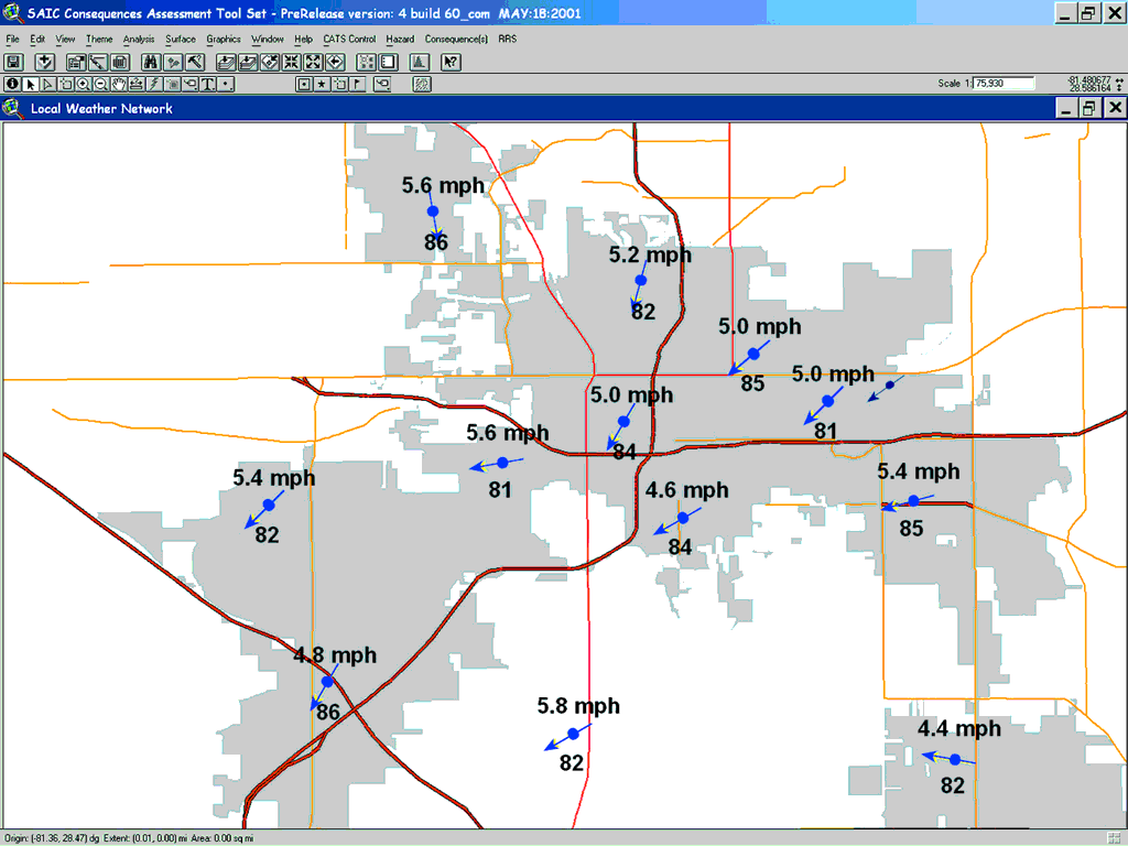
MxInsight Analyst, an extension for ArcView 3.2, provides a menu and tools for integrating and viewing GIS-converted weather data from the Meteorlogix data stream and the Orlando weather network to assist in hazard analysis. Emergency services personnel can determine if and when severe weather might impact emergency response plans by adding Doppler weather radar and severe storm tracking information directly into the CATS-ArcView display. In addition, the severe weather events most likely to affect the Orlando area--hurricanes, severe thunderstorms, often with heavy rain, and tornadoes--can be overlaid onto a detailed map of the City of Orlando and used to determine, for example, the precise location of a particularly dangerous thunderstorm cell. Real-Time Severe Weather AlertsCity departments need to be alerted to severe weather situations so that they can provide quick and accurate response. MxInsight MetroWatch provides real-time alerts of severe weather conditions for more accurate decision making. These timely alerts allow public safety professionals to proactively plan for and act to appropriately handle a severe weather situation--not merely react. Urban Hydrologic AnalysisPrecise knowledge of rainfall coverage and amounts is necessary to better manage urban watersheds. Historical data is important in hydrologic planning and real-time, highly localized rainfall data is needed for flash flood response and management. MxInsight MetroWatch provides unique rainfall estimates derived from radar in addition to real-time rain monitoring from conventional rain gauges. ResultsImplementation of the City of Orlando MxInsight MetroWatch system began in January 2002 and was completed in the summer of 2002. The City of Orlando is now positioned to dramatically improve public safety responsiveness to severe weather situations, biohazards, and chemical threats. Although it is still early to accurately assess what the long-term results will be, early feedback from the City of Orlando is positive. "We are always looking to make Orlando a safer city," says Greg Gentleman, administrative officer, Orlando Fire Department. "The ability to display and analyze national weather data plus real-time weather observations from numerous points across the City makes it easier for us to make more informed decisions in order to better protect the public." For more information, contact About the AuthorClive Reece manages the MxInsight GIS weather products for Meteorlogix where he has worked with GIS and weather technology integration for the past three years. Prior to working at Meteorlogix, he was assistant professor of environmental biophysics at the University of Minnesota, Department of Soil, Water, and Climate. Meteorlogix (www.meteorlogix.com), based in Minneapolis, delivers industry-specific weather management capabilities that allow customers to manage weather-related business risks, maximize personal safety, and minimize financial loss. Meteorlogix serves more than 22,000 customers with a focus on public safety, broadcast media, transportation, energy, and aviation industries. |