GIS Users Come Together in San Diego
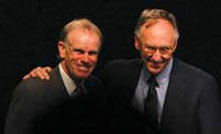 |
| Peter Hillary, conference keynote speaker, is shown with Esri President Jack Dangermond. |
"In the context of good relationships, we learn." With these words, Esri President Jack Dangermond welcomed more than 11,000 GIS professionals to San Diego, California, for the 23rd Annual Esri International User Conference. Still the largest GIS event in the world, it was held July 7-11, 2003, and gave attendees unparalleled opportunities for meeting and learning from fellow GIS users.
"GIS and geographic science will provide a new framework for organizing measurements, accounting for change, supporting transactions, mapping and visualizing our world, and modeling the future. I believe this means the GIS community will both philosophically and in actuality be serving (saving) our world," said Dangermond, underlying the conference's theme "Geography and GIS—Serving Our World."
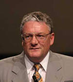 |
| Dr. David Maidment of the University of Texas, Austin, received the Lifetime Achievement award. |
The software demonstrations that followed Dangermond's address demonstrated more powerful tools that will be available with the release of ArcGIS 9 for exploring, analyzing, monitoring, and modeling the world. ArcGlobe, the showstopper, is a revolutionary new application for three-dimensional visualization and analysis on a global scale. ArcGlobe delivers breathtaking scale changes and direct access to all geodatabase feature classes.
In addition to ArcGlobe, ArcGIS 9 introduces two new architectural features—a multienvironment developer product called ArcGIS Engine and ArcGIS Server, the first full implementation of GIS capabilities in a true multiuse server environment.
ArcGIS 9 will give users many more geoprocessing functions and additional choices in working styles that range from command line input to drag-and-drop modeling.
 |
| Herman Robinson, who is retiring from the United States Fish and Wildlife Service, received the Distinguished Service in GIS award. |
The conference not only previewed future GIS developments but also celebrated achievements in applying GIS. The conference special exhibits illustrated innovative and beneficial uses of GIS. A few of the 16 exhibits are described here-see www.esri.com/uc for more complete information.
Historical globes, maps, and atlases from David Rumsey's world-renowned collection were on display. "Our Earth as Art: A Landsat Perspective," a collection of more than 40 beautiful Landsat images from the National Aeronautics and Space Administration (NASA) and the United States Geological Survey, presented more recent perspectives of the earth. The most accurate and detailed depiction of Mt. Everest was the centerpiece of the National Geographic Society exhibit and complemented the conference keynote address by Peter Hillary.
The son of Sir Edmund Hillary, he is a renowned climber in his own right. Hillary's most recent Mt. Everest climb in May 2002 commemorated the 50th anniversary of his father's inaugural climb. Hillary spoke of the challenges GIS professionals face in their work. "We need to see them [challenges] in the context of the big picture—just another step in the tome of exploration, looking forward, and doing great things while taking advantage of what we've learned in the past. Summits are lost ground. They are brief successes, and you must see them for what they are. The process of getting there is the exciting, dynamic part and it is ongoing. There is no end to the challenge."
 |
| Assistant Secretary for Policy and Management Lynn Scarlett accepting the President's award on behalf of the United States Department of the Interior. |
An exhibit by the Federal Emergency Management Administration (FEMA) and the Space Shuttle Columbia Debris Recovery GIS Team chronicled how both organizations used GIS to recover shuttle debris scattered over five states. FEMA and the GIS team garnered the Making a Difference award for their work on this project.
Outstanding work by organizations and individuals was recognized at the conference. Special Achievement in GIS awards were presented to 134 organizations. (See the accompanying article.) The Lifetime Achievement award went to Dr. David Maidment of the University of Texas, Austin, for his contributions to the use of geographic information systems in hydrology and his work in developing the ArcGIS hydrology data model (Arc Hydro). Herman Robinson, who is retiring from the Fish and Wildlife Service, received the Distinguished Service in GIS award. The President's award recognized the pioneering work of the United States Department of the Interior. In accepting the award on the department's behalf, Assistant Secretary for Policy and Management Lynn Scarlett observed, "Geography and geographic information systems are our heartbeat."
Next year's conference will again be held in San Diego, California, but is slated for one month later, August 9–13, 2004.
|