Protecting Communities
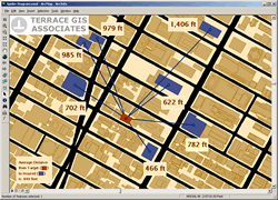 |
| By modeling threats, such as the bomb blast shown here, GIS is helping decision makers identify plan response, mitigate adverse conditions, and make the best decisions in a timely manner. |
It influences cultures and connects societies and is the common thread that ties the world of man to the natural world. Belief in the fundamental importance of geography led to the development of GIS. Whether inventorying farm land, supporting optimal land use planning, or monitoring environmental contaminants, it was seen as a technology for enhancing analytical decision making and, by extension, for improving the quality of life in communities. From its inception in the mid-1960s, GIS has been a tool for maintaining and protecting communities and its use has steadily expanded across industries and disciplines in the public and private sectors the world over.
"We live in a natural, self-regulating, evolving world. We also live in a man-made world that is increasingly becoming managed," said Esri President Jack Dangermond in his address during the plenary session of the 2003 Esri International User Conference. "Because of expanding population, consumption, and land use many of our natural resources are declining and this is creating problems for the two worlds we live in."
A Smaller World
As human populations have grown in size, the complexity and speed of their interactions has also increased as well as their impact on the world's ecology. With the advent of widespread air travel and the Internet, the global village that communication theorist Marshall McLuhan spoke of is becoming a reality. In this relatively new and challenging environment, almost no one can live in isolation.
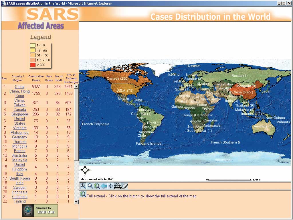
The outbreak of Severe Acute Respiratory Syndrome (SARS) on a worldwide scale demonstrated that the ease of travel currently enjoyed by much of the world also means that disease outbreaks can quickly spread far and wide. In just five months, the virus spread from Guangdong province in China to 30 countries and areas of the world. As of July 2003, 8,439 people had been infected by the disease and 812 had died from it proving that disease outbreaks can pose a threat, no matter how distant the origin.
Moving Into Harm's Way
Not only is the world's population both growing and mobile, it is also migrating to coastlines, the borders of forest land, and other areas that are at much greater risk for natural disasters such as hurricanes, floods, and fires. According to a report written by Don Hinrichesen for the Association for the Advancement of Science's Program on Ecology and Human Needs (EHN), over the last 30 years coastal populations in the United States have grown by 41 million—a rate that is faster than that for the country as a whole. Now 54 percent of all Americans now live in coastal counties.
 |
| The outbreak of Severe Acute Respiratory Syndrome (SARS) on a worldwide scale demonstrated that disease outbreaks can quickly spread far and wide. |
Natural disasters occur at the intersection of populations and natural events. As populations increase, these events become more costly in terms of human life and property. According to the United Nations, the world's natural disasters kill one million people each decade. In addition to these human losses, the economic cost of natural disasters has tripled in the last 30 years.
In addition to concerns about disease outbreaks and natural disasters, there is a heightened awareness of threats from terrorists that employ weapons ranging from bombs to computer viruses. According to a survey by the Washington, D.C.-based National League of Cities (NLC) in 2002, more than half of America's cities fear terrorist attack. Since September 11, 2001, local governments have been looking for better ways to protect their communities from these threats.
Expanding the Role of GIS
Faced with these diverse and increasing threats to communities, government agencies at all levels are recognizing that GIS can help them monitor conditions, recognize threats, and respond effectively and quickly. A common GIS-based framework makes current data and information of all types readily accessible and breaks down "stovepipes" of information within organizations. Recent improvements in interoperability and the emphasis on industry-standard development environments have made GIS an integral part of the mainstream IT world.
In addition to its capabilities as a data management and integration tool, GIS is tremendously effective in analyzing data and communicating information. Spatial analysis, arguably the most powerful and unique aspect of GIS, reveals patterns and relationships that could not otherwise be discerned. The results of analysis can be efficiently conveyed through a map and made comprehensible in a way not possible with reports or lists.
GIS benefits exponentially from data sharing. The creation of data models, emphasis on metadata creation, development of the spatial data infrastructure, and the adoption of standard formats have all fostered data sharing. GIS has evolved from a project-oriented helper application to an information infrastructure that is being integrated with the Internet. It has become a technology with the potential to create a nervous system for the planet that can help deal with threats to the global community.
Leading the Way
The articles in this section describe GIS applications that have been developed to protect communities against man-made as well as naturally occurring threats. The demands on the health care system have increased. A greater level of preparedness is now required because large-scale, health-related events can occur with nearly no warning. An article by Bill Davenhall, Esri health and human services solutions manager, outlines how hospitals can benefit from leveraging existing information systems. Implementing an automated low-cost system that adds geospatial intelligence to health-related data will enhance the response of hospitals to threats or critical events, whether caused by nature or humans.
Other articles in the Focus section illustrate how GIS is being integrated with existing software and IT infrastructure. The city of Wilson, North Carolina, has adopted an online reporting system for chemical storage sites that furnishes responders with current information on the site and the surrounding area.
Chemical spills are also the subject of an article about a pilot program that is being developed in Erie County in New York. The application models the chemical gas cloud or "plume" caused by an accidental chemical release and integrates with existing Environmental Protection Agency software. A GIS-based strategy for safeguarding the food supply is being developed by the Missouri Department of Agriculture. Ryan Lanclos describes how the department is monitoring confined animal feeding operations to better respond to disease outbreaks. In each case, GIS is helping decision makers identify threats, obtain the best data, plan response, mitigate adverse conditions, and make the best decisions in a timely manner to safeguard communities.
|